North Khorasan Province
| North Khorasan Province استان خراسان شمالی | |
|---|---|
| Province | |
 Location of North Khorasan within Iran | |
| Coordinates: 37°28′34″N 57°19′54″E / 37.4761°N 57.3317°E | |
| Country |
|
| Region | Region 5 |
| Capital | Bojnord |
| Counties | 7 |
| Area | |
| • Total | 28,434 km2 (10,978 sq mi) |
| Population (2011)[1] | |
| • Total | 867,727 |
| • Density | 31/km2 (79/sq mi) |
| Time zone | IRST (UTC+03:30) |
| • Summer (DST) | IRST (UTC+04:30) |
| Main languages |
Persian Kurdish Turkmen Khorasani Turkic |
North Khorasan Province (Persian: استان خراسان شمالی, Ostān-e Khorāsān-e Shomālī) is a province located in northeastern Iran. Bojnord is the capital of the province. In 2014 it was placed in Region 5.[2]
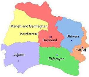
Other counties are Shirvan, Esfarayen, Maneh and Samalqan, Raz and Jargalan county Jajarm, Faroj and Garmeh.
North Khorasan is one of the three provinces that were created after the division of Khorasan in 2004.
History
Greater Khorasan has witnessed the rise and fall of many dynasties and governments in its territory throughout history. Various tribes of Persians, Arabs, Turks, Kurds,[3] Mongols, Turkmen, and Afghans have brought change to the region time and time again.
Ancient geographers of Iran divided Iran ("Iran-Shahr") into eight segments of which the most flourishing and largest was the territory of Greater Khorasan. Esfarayen, among other cities of the province, was one of the focal points for settlement by Aryan tribes entering Iran.
The Parthian empire was based near Merv in Khorasan for many years. In Parthian times, Esfarayen was one of the important villages of Nishapur.
During the Sassanid dynasty the province was governed by a Spahbod (Lieutenant General) called "Padgoosban" and four margraves, each commander of one of the four parts of the province.
Khorasan was divided into four parts during the Muslim conquest of Persia, each section being named after the four largest cities, Nishapur, Merv, Herat, and Balkh.
In the year 651, the army of Islamic Arabs invaded Khorasan. The territory remained in the hands of the Abbasid clan until 820, followed by the rule of the Iranian Taherid clan in the year 896 and the Samanid dynasty in 900.
Mahmud of Ghazni conquered Khorasan in 994 and in the year 1037 Tuğrul Beg, the first of the Seljuq empire rulers conquered Nishapur.
Mahmud Qaznavi retaliated against the invaders several times, and finally the Qaznavi Turks defeated Sultan Sanjar. But there was more to come, as in 1157 Khorasan was conquered by the Khwarazmids. In 1220 was annexed by the Mongols of Chiggis Qa'an. When in 1226 the great conqueror finally died, the Khorasan was inheriter by his son Tolui and then by the son of this, who's named Hulegu, the first emperor of the mongolic Ilkhanate of Persia.
In the 14th century, a flag of independence was hoisted by the Sarbedaran movement in Sabzevar, and in 1368, Khorasan came into the hands of Tamerlane.
In 1507, Khorasan was occupied by Uzbek tribes. After the death of Nader Shah in 1747, it was occupied by the Afghans.
During the Qajar period, Britain supported the Afghans to protect their East India Company. Herat was thus separated from Persia, and Nasser-al-Din Shah was unable to defeat the British to take back Herat. Finally, the Paris Treaty was concluded in 1903 and Iran was compelled not to challenge the British for Herat and other parts of what is today Afghanistan.
Finally Khorasan was divided into two parts: the eastern part, which was the most densely populated region came under British occupation, and the other western section remained part of Iran.
Khorasan was the largest province of Iran until it was divided into three provinces on September 29, 2004. The provinces approved by the parliament of Iran (on May 18, 2004) and the Council of Guardians (on May 29, 2004) were Razavi Khorasan, North Khorasan, and South Khorasan.
North Khorasan today
North Khorasan province is one of the most diverse territories in Iran today, largely reflecting the ethnic make-up of Iran. Kurdish speakers make up 46.1%, forming the relative majority (plurality) of the population. The next largest group is Persian speakers which make up 27.8% of the population, Khorasani Turks make up 20.6% and Turkmens make up about 3.3% and other Iranians make up 2.2% of the population. There used to be a sizeable population of Lurs who used to inhabit this province, however most returned to their native area in western Iran as there are no signs of them in the province today[4]
Previously there used to be a sizeable community of Arabs who settled in the area during the Arab invasion of Iran, however by 1875 they had intermarried so extensively with Persians and Turks that they were indistinguishable in feature and language, having largely abandoned the Arab language and culture in favour of the local one.[5]
Administrative divisions
Main sights
This province contains many historical and natural attractions, such as mineral water springs, small lakes, recreational areas, caves and protected regions, and various hiking areas. Most of the historical relics are from the Qajar era, as earthquakes continue to ravage older relics.
The Cultural Heritage Organization of Iran lists 1,179 sites of historical and cultural significance in all three provinces of Khorasan.
Some of the popular attractions of North Khorasan are:
- Tepe Pahlavan, near Jajarm, A prehistoric archeological site
- Jalalal-din castle, Jajarm
- Miandasht wildlife refuge, living place of Asiatic Cheetah
- petroglyphic site from Bronze Age in Jorbat (10 km north of Jajarm)
- Sari Gol protected area,
- Hasanabad, Ghaisar and Solak old castles,
- Noshirvan and Ebadatgah caves,
- Faghatdezh castle,
- Tomb of Sheikh Ali Esfarayeni
- Saloog Protected Area,
- Besh Qardash (five brothers) and Baba-Aman springs,
- Bidag, Konegarm, Konjekooh, Armadloo and Seyed Sadegh caves,
- Mofakham mirror house (image), built during the Qajar era
- Baba Tavakol mausoleum,
- Imamzadeh Sultan Seyed Abbas
- Salook Protected Area
- Bazkhaneh valley
- Ayyub mineral water spring
- Ruwin village
Colleges and universities
- University of Bojnurd
- Islamic Azad University of Bojnurd
- Eshragh Institute of Higher Education (Bojnurd, North Khorasan)
- Islamic Azad University of Shiravan
- Hakiman Institute of Higher Education (Bojnurd, North Khorasan)
- Khorasan University of Medical Science (Bojnurd, North Khorasan)
See also
References
- ↑ Selected Findings of National Population and Housing Census 2011
- ↑ "همشهری آنلاین-استانهای کشور به ۵ منطقه تقسیم شدند (Provinces were divided into 5 regions)". Hamshahri Online (in Persian). 22 June 2014 (1 Tir 1393, Jalaali). Archived from the original on 23 June 2014. Check date values in:
|date=(help) - ↑
- ↑ The ethnic groups in Northern Khorasan, "", accessed in March 2014.
- ↑ "C. M. MacGregor, Narrative of a Journey through the Province of Khorassan, London, 1879, p. 141 ", accessed in March 2014.
External links
- The text of the law for division of Khorasan into three provinces (in Persian)
- Cultural Heritage Foundation of Khorasan
 |
Balkan Province, |
Ahal Province, |
| |
| Golestan Province | |
|||
| ||||
| | ||||
| Semnan Province | Razavi Khorasan Province |
| Capital |  | ||||||||||||||||||||||||||
|---|---|---|---|---|---|---|---|---|---|---|---|---|---|---|---|---|---|---|---|---|---|---|---|---|---|---|---|
| Counties and cities | |||||||||||||||||||||||||||
| Sights |
| ||||||||||||||||||||||||||
| populated places | |||||||||||||||||||||||||||