North Wagga Wagga
| North Wagga Wagga Wagga Wagga, New South Wales | |||||||||||||
|---|---|---|---|---|---|---|---|---|---|---|---|---|---|
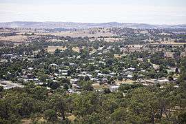 Aerial view of North Wagga | |||||||||||||
| Coordinates | 35°5′44.48″S 147°22′40.01″E / 35.0956889°S 147.3777806°ECoordinates: 35°5′44.48″S 147°22′40.01″E / 35.0956889°S 147.3777806°E | ||||||||||||
| Population | 1,187 (2006)[1] | ||||||||||||
| Postcode(s) | 2650 | ||||||||||||
| LGA(s) | City of Wagga Wagga | ||||||||||||
| County | Clarendon | ||||||||||||
| Parish | North Wagga Wagga | ||||||||||||
| State electorate(s) | Wagga Wagga | ||||||||||||
| Federal Division(s) | Riverina | ||||||||||||
| |||||||||||||
North Wagga Wagga (informally called North Wagga) is an inner northern suburb of Wagga Wagga, New South Wales, Australia, located on the floodplain of the Murrumbidgee River, directly across from the city's Central Business District. North Wagga is one of Wagga's oldest suburbs, being settled at approximately the same time as Wagga. Two pubs are located within North Wagga - The Black Swan Hotel and the Palm and Pawn Hotel, as well as a public school, a public hall, a football/cricket ground and a scattering of business and churches.
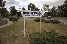
Due to its flood prone nature, Wagga Wagga City Council long sought to deter development in North Wagga and aimed for its residents to relocate. For many years the level of services provided in North Wagga were inferior to the rest of Wagga, and most alterations and additions to dwellings were prohibited. In 1960, a levee bank was built around Wagga to protect it from flood inundation, however North Wagga was not included in this protection. It was during this time that North Wagga's slogan "We Shall Not Be Moved" first appeared.[2]

It was not until the late 1970s that the Council relented on its restrictions on development and built a levee around the suburb, however to this day it is lower than the main city levee and only affords protection to flood events up to 9.9 metres (32 ft), approximately 1 in 20 year in size. In March 2012, the suburb was inundated after the levee was over-topped after the Murrumbidgee River reached 10.56 metres (34.6 ft), 0.18 metres (0.59 ft) below the 1974 flood, after record rainfall fell over a large area of the Riverina and the Murrumbidgee River catchment.[3][4]
References
- ↑ Australian Bureau of Statistics (25 October 2007). "North Wagga Wagga (State Suburb)". 2006 Census QuickStats. Retrieved 2008-06-29.
- ↑ Morris, S (1999). Wagga Wagga, a history. Bobby Graham Publishers, Wagga Wagga. ISBN 1-875247-12-2
- ↑ Kwek, Glenda (7 March 2012). "Wagga 'dodges a bullet' as severe weather warning issued for Sydney". Sydney Morning Herald. Retrieved 11 March 2012.
- ↑ "Murrumbidgee peak falls short". The Daily Advertiser. 6 March 2012. Retrieved 11 March 2012.
Further reading
- Morris, S 1980, We Shall Not Be Moved: A History of North Wagga and its School 1880 – 1980.
External links
![]() Media related to North Wagga Wagga at Wikimedia Commons
Media related to North Wagga Wagga at Wikimedia Commons