North and South Cliffe
| North and South Cliffe | |
|---|---|
| Civil parish | |
 | |
| Coordinates: 53°49′11″N 0°41′17″W / 53.81972°N 0.68806°WCoordinates: 53°49′11″N 0°41′17″W / 53.81972°N 0.68806°W | |
| Country | England |
| Primary council | East Riding of Yorkshire |
| Region | Yorkshire and the Humber |
| Status | Parish |
| Government | |
| • Type | Parish Council |
| • UK Parliament | East Yorkshire |
| • EU Parliament | Yorkshire and the Humber |
| Population (2011 census)[1] | |
| • Total | 124 |
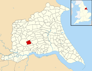
North and South Cliffe is a civil parish in the East Riding of Yorkshire, England. It is situated approximately 3 miles (4.8 km) south of the market town of Market Weighton and covering an area of 1,412.967 hectares (3,491.52 acres).[2]
The civil parish is formed by the villages of North Cliffe and South Cliffe.
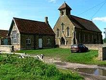
Parish Church of St John, serving North and South Cliffe
According to the 2011 UK census, North and South Cliffe parish had a population of 124,[1] an increase on the 2001 UK census figure of 96.[3]
References
- 1 2 "Key Figures for 2011 Census: Key Statistics: Area: South Cliffe CP (Parish)". Neighbourhood Statistics. Office for National Statistics. Retrieved 6 February 2013.
- ↑ "2001 Census Area Profile" (PDF). East Riding of Yorkshire County Council. 2004. Archived (PDF) from the original on 12 February 2012. Retrieved 8 February 2013.
- ↑ "2001 Census: Area Profiles - North and South Cliffe" (PDF). East Riding of Yorkshire Council. Retrieved 19 May 2008.
- Gazetteer — A–Z of Towns Villages and Hamlets. East Riding of Yorkshire Council. 2006. pp. 8, 10.
External links
![]() Media related to North and South Cliffe at Wikimedia Commons
Media related to North and South Cliffe at Wikimedia Commons
This article is issued from Wikipedia - version of the 9/9/2016. The text is available under the Creative Commons Attribution/Share Alike but additional terms may apply for the media files.