Northern Line (Merseyrail)
| Northern Line | |
|---|---|
|
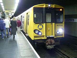
A Northern Line Class 507 at Liverpool Central. | |
| Overview | |
| Type | Commuter rail |
| System | National Rail |
| Status | Operational |
| Locale |
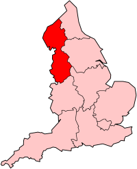
Liverpool North West England |
| Termini |
Southport Hunts Cross |
| Stations | 35 |
| Operation | |
| Owner | Network Rail |
| Operator(s) | Merseyrail[1] |
| Depot(s) | Kirkdale TMD |
| Rolling stock |
British Rail Class 507 British Rail Class 508 |
| Technical | |
| Track gauge | 1,435 mm (4 ft 8 1⁄2 in) standard gauge |
| Loading gauge | W6[2] |
| Electrification | 750 V DC third rail[3] |
| Operating speed | 60 mph (97 km/h) maximum[2][4] |

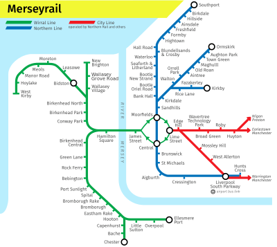
The Northern Line is one of the two commuter rail lines operated[5] by Merseyrail in Merseyside, England, with Wirral Line being the other. A third line, the City Line, is not owned or operated by Merseyrail. All three lines are funded by Merseytravel.
The Northern Line passes underground through Liverpool city centre with termini at:
- Hunts Cross to the south;
- Southport,
- Ormskirk, and
- Kirkby to the north.
Description
The line runs from Hunts Cross via the Cheshire Lines Committee (CLC) route towards Liverpool Central. Brunswick station between St Michaels and Liverpool Central was added in 1998 to provide a connection to the Brunswick Business Park. Just south of Liverpool Central, the line leaves the CLC route, in tunnel at that point, into a 1970s tunnel that drops to a lower level into the underground Mersey Railway Liverpool Central (Low Level) station. North of Central the line uses the Mersey Railway tunnel for about half of the route to Moorfields, an underground station built in the 1970s to replace the surface-level Liverpool Exchange. North of Moorfields the route emerges from the tunnel to join the Lancashire and Yorkshire Railway lines from the former Exchange station.
After Sandhills, the Liverpool, Crosby and Southport Railway branches off towards Southport, while the other routes continue to Kirkdale on what was a joint section of track between Liverpool, Ormskirk and Preston Railway and the Liverpool and Bury Railway. After Kirkdale, the Ormskirk and Kirkby lines diverge.
Trains from Hunts Cross continue to Southport, while trains to Ormskirk and Kirkby start at Liverpool Central. Daytime trains operate every 15 minutes on each of the three routes Monday to Saturday and every 30 minutes on Sundays, except in summer when Sunday frequencies on the Southport route are increased to every 15 minutes. In peak hours the frequency on that route is every eight minutes during peak hours, when trains on the Southport and Ormskirk routes are increased to six carriages, as are weekend services during the summer on the Southport route.
Electrification
The line is electrified using 750 V DC third rail.
- Liverpool Exchange to Southport, Crossens and Meols Cop was the first section to be electrified, in 1904.
- The branch to Aintree, on the Ormskirk branch, followed in 1906, extended to Ormskirk in 1913.
- The Kirkby branch and the line south to Garston were electrified to create a north-south line through the Link Tunnel in 1978.
- Electrification was cut back to Southport in the north in 1964, though the conductor rail remained until 1970 to serve the large depot at Meols Cop.[6]
- Garston to Hunts Cross was electrified in 1983.
Connections
Interchange with the Wirral Line is available at Liverpool Central and Moorfields. As the Northern Line does not pass through Liverpool Lime Street, passengers must use the Wirral Line as a connection, but given the short distance between Central and Lime Street, many with light luggage prefer to walk.
Interchange with other National Rail services can be made at Southport, Ormskirk, Kirkby, Liverpool South Parkway and Hunts Cross.
Liverpool South Parkway opened on 11 June 2006, replacing Garston and providing connections to the City Line formerly available at Allerton.
Former stations
This list is incomplete. Apart from Garston, all closures were prior to the formation of the Northern Line.
- Churchtown (Closed 1964)
- Crossens (Closed 1964)
- Ford (Closed 1951)
- Garston (Closed 2006)
- Hesketh Park (Closed 1964)
- Linacre Road (Closed 1951)
- Liverpool Exchange (Closed 1977)
- Otterspool (Closed 1951)
- St James (Closed 1917)
- Aintree Racecourse (Closed 1962)
- Altcar Rifle Range (Closed 1921)
- Formby Power Station (Closed 1944)
- Millers Bridge (Closed 1876)
- Bootle Village (Closed 1876)
Passenger volume
Passengers from the year beginning April 2002 to the year beginning April 2010.
| Station usage | |||||||||||
|---|---|---|---|---|---|---|---|---|---|---|---|
| Station Name | 2004–05 | 2005–06 | 2006–07 | 2007–08 | 2008–09 | 2009–10 | 2010–11 | 2011–12 | 2012–13 | 2013–14 | 2014–15 |
| Southport branch | |||||||||||
| Southport | 1,080,767 | 1,549,576 | 1,582,115 | 1,669,056 | 1,681,444 | 3,094,576 | 2,949,656 | 2,886,448 | |||
| Birkdale | 164,753 | 251,641 | 256,424 | 270,277 | 289,106 | 820,240 | 783,066 | 770,104 | |||
| Hillside | 125,031 | 158,618 | 178,252 | 177,678 | 180,744 | 688,812 | 579,460 | 590,254 | |||
| Ainsdale | 210,317 | 289,260 | 322,911 | 328,423 | 345,791 | 998,438 | 955,328 | 972,616 | |||
| Freshfield | 169,370 | 249,567 | 266,415 | 277,933 | 283,772 | 827,718 | 798,444 | 795,312 | |||
| Formby | 279,822 | 424,875 | 482,312 | 525,841 | 553,546 | 1,668,128 | 1,576,974 | 1,595,890 | |||
| Hightown | 84,188 | 117,664 | 133,241 | 141,686 | 150,991 | 439,588 | 409,956 | 416,844 | |||
| Hall Road | 50,377 | 69,251 | 76,158 | 88,355 | 91,686 | 288,584 | 270,198 | 269,744 | |||
| Blundellsands and Crosby | 296,685 | 457,346 | 518,823 | 561,676 | 599,071 | 1,839,920 | 1,717,962 | 1,735,882 | |||
| Waterloo (Merseyside) | 433,285 | 601,447 | 660,922 | 669,416 | 720,522 | 1,136,872 | 1,022,416 | 1,014,942 | |||
| Seaforth and Litherland | 176,145 | 300,292 | 335,884 | 337,209 | 362,341 | 832,894 | 766,468 | 789,156 | |||
| Bootle New Strand | 345,451 | 415,685 | 404,558 | 348,458 | 405,802 | 977,696 | 909,922 | 931,806 | |||
| Bootle Oriel Road | 57,791 | 155,295 | 203,956 | 249,030 | 209,041 | 523,944 | 511,614 | 521,576 | |||
| Bank Hall | 51,477 | 71,052 | 74,624 | 62,692 | 85,014 | 197,086 | 171,010 | 172,426 | |||
| Ormskirk branch | |||||||||||
| Ormskirk | 726,015 | 693,376 | 716,362 | 733,381 | 770,621 | 1,026,546 | 998,858 | 878,782 | |||
| Aughton Park | 95,060 | 86,413 | 83,012 | 89,200 | 85,699 | 124,736 | 109,592 | 96,224 | |||
| Town Green | 188,160 | 183,233 | 203,324 | 202,425 | 206,180 | 259,972 | 239,100 | 193,200 | |||
| Maghull | 394,191 | 431,945 | 502,020 | 610,318 | 696,791 | 2,144,046 | 1,999,436 | 1,956,936 | |||
| Old Roan | 177,332 | 260,871 | 284,901 | 305,589 | 337,166 | 918,262 | 861,176 | 863,568 | |||
| Aintree | 284,514 | 388,230 | 376,908 | 412,132 | 473,143 | 1,251,404 | 1,173,276 | 1,197,258 | |||
| Orrell Park | 369,037 | 452,889 | 473,979 | 469,256 | 491,948 | 1,257,746 | 1,170,676 | 1,192,140 | |||
| Walton (Merseyside) | 65,155 | 93,261 | 110,471 | 113,214 | 113,131 | 179,148 | 162,612 | 164,478 | |||
| Kirkdale | 299,396 | 410,808 | 452,155 | 441,525 | 479,342 | 1,179,346 | 1,085,418 | 1,099,018 | |||
| Kirkby branch | |||||||||||
| Kirkby | 350,098 | 516,007 | 560,285 | 639,337 | 739,590 | 2,191,476 | 2,050,590 | 2,006,486 | |||
| Fazakerley | 215,019 | 300,552 | 329,306 | 318,664 | 330,843 | 889,816 | 832,474 | 864,108 | |||
| Rice Lane | 64,677 | 102,525 | 116,590 | 118,113 | 133,723 | 330,818 | 307,116 | 323,310 | |||
| Kirkdale | See above | See above | See above | See above | See above | See above | See above | See above | |||
| Bank Hall\Kirkdale to Hunts Cross | |||||||||||
| Sandhills | 178,991 | 272,009 | 314,309 | 306,134 | 207,944 | 390,346 | 446,210 | 495,458 | |||
| Moorfields | 339,533 | 309,014 | 383,815 | 1,577,540 | 2,141,398 | 5,141,655 | 4,445,984 | 4,637,356 | |||
| Liverpool Central | 1,086,536 | 982,498 | 1,293,790 | 7,169,618 | 8,856,570 | 19,635,814 | 18,413,982 | 17,958,028 | |||
| Brunswick | 224,476 | 352,854 | 407,134 | 410,813 | 442,711 | 1,061,698 | 979,312 | 963,252 | |||
| St Michaels | 195,408 | 289,183 | 365,547 | 360,976 | 378,944 | 562,860 | 506,288 | 469,570 | |||
| Aigburth | 146,283 | 179,458 | 241,063 | 246,583 | 265,442 | 761,362 | 696,992 | 681,774 | |||
| Cressington | 74,789 | 120,034 | 152,383 | 164,734 | 170,409 | 456,042 | 424,174 | 421,076 | |||
| Garston (Merseyside) | 141,022 | 190,778 | 222,247 | 42,886 | Closed | Closed | Closed | Closed | |||
| Liverpool South Parkway | - | - | - | 288,845 | 419,681 | 568,822 | 581,898 | 641,662 | |||
| Hunts Cross | 277,961 | 326,258 | 443,837 | 464,367 | 503,426 | 1,269,710 | 1,190,934 | 1,172,150 | |||
| The annual passenger usage is based on sales of tickets in stated financial years from Office of Rail Regulation statistics. The statistics are for passengers arriving and departing from each station and cover twelve month periods that start in April. Please note that methodology may vary year on year. | |||||||||||
See also
- LYR electric units
- A59 road, which follows the same route.
References
- ↑ "Merseyrail - About Merseyrail". Merseyrail. Retrieved 30 May 2011.
- 1 2 "Merseyside Route Utilisation Strategy" (PDF). Network Rail. 25 March 2009. Retrieved 4 August 2010.
- ↑ "04 - Current Capability" (PDF). Network Rail. 1 August 2008. Retrieved 30 May 2011.
- ↑ "Track and Route mileage (1). Line-speeds (2) - London North Western (North)" (PDF). Baseline Declaration. Network Rail. 31 March 2009. Retrieved 4 August 2010.
- ↑ Merseyrail - A brief History (PDF), merseytravel.gov.uk, retrieved 2009-01-04
- ↑ http://www.disused-stations.org.uk/features/meols_cop_triangle/index.shtml
External links
| Wikimedia Commons has media related to Northern Line (Merseyrail). |
Coordinates: 53°24′16″N 2°58′47″W / 53.4045°N 2.9798°W


