Northern Territory borders
Today the Northern Territory's land borders are defined to the west by the 129° east longitude (129° east) with Western Australia, to the south by the 26th parallel south latitude (26° south) with South Australia and to the east by 139° east longitude (139° east) with Queensland; however, this is not where all borders are actually marked on the ground.
The Northern Territory boundaries are shared with the West Australian border, the South Australian border, and the Queensland border.
History
1788-1832
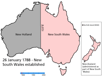
In 1788, Governor Phillip claimed the continent of Australia as far west as the 135th meridian east longitude (135° east) in accordance with his commission.[1] (26 January 1788 - Map)
On 16 July 1825, the western boundary of New South Wales was relocated to the line of 129° east to take in the new settlement at Melville Island.[2] (16 July 1825 - Map). From 1825 to 1829 129° east was the NSW border.
Following the settlement of the Swan River Colony in 1829 (2 May 1829 - Map), its eastern boundary was declared to be 129° east, coinciding with the western boundary of New South Wales at the time.[3]
The colony of Western Australia (WA) was commissioned in March 1831.[4]
From 1829 to 1832, the SRC/NSW border was at 129° east.
1832-1836
The name of the Swan River Colony was changed to Western Australia in 1832 (6 February 1832 - Map).[5]
From 1832 to 1846, 129° east was the WA/NSW border.
1836-1846
South Australia became a colony in 1836 and until 1846 would be surrounded on land by New South Wales (NSW), with South Australia extending west to the 132° east longitude. (132° east) and north to 26° south (28 December 1836 - Map).[6]
From 1836 to 1846 129° east was the WA/NSW border. 132° east was the SA/NSW border as were 26° south and 141° east.
1846-1847
In 1846 the colony of North Australia (NA) was proclaimed by Letters Patent, which was all of New South Wales north of 26° south (17 February 1846 - Map).[7]
From 1846 to 1847 129° east was the WA/NSW border and the WA/NA border. 132° east was the SA/NSW border, while 26° south became the SA/NA border and 141° east remained the SA/NSW border.
1847-1851
In 1847 the colony of North Australia was revoked and reincorporated into New South Wales. (15 April 1847 - Map), so South Australia was once again surrounded by New South Wales on all land borders.[8]
From 1847 to 1860 129° east was once again the WA/NSW border.
From 1847 132° east was again the SA/NSW border, and 26° south was also the SA/NSW border. 141° east would remain the SA/NSW border until 1851.
1851-1859
In 1851 South Australia's eastern border changed again when the colony of Victoria was proclaimed (1 July 1851 - Map).[9]
From 1851 141° east would change to include both the SA/NSW border and the SA/VIC border.
1859-1860
In 1859 The colony of Queensland is proclaimed by Letters Patent, with its western border set at 141° east (6 June 1859 - Map).[10]
From 1859 141° east would change to include the SA/QLD border, the SA/NSW border and the SA/VIC border.
1860-1862
In 1860 the western border of South Australia changed from 132° east to 129° east (1860 - MAP).[11]
From this time on South Australia's western border was also the West Australian border.
From 1860 129° east became the SA/WA border from south of 26° south & the WA/NSW border north of 26° south.
1862-1863
In 1862 Queensland's western border north of 26° south) was moved to 139° east (1862).[12]
From 1862 26° south became shared as the SA/NSW border and the SA/QLD border between 139° east and 141° east.
1863-1911
In 1863 that part of New South Wales to the north of South Australia was annexed to South Australia by Letters Patent as the Northern Territory of South Australia, which was shortened to the Northern Territory (6 July 1863 - Map).[13]
From 1863 to 1911 129° east was the WA/NToSA border north of 26° south & the WA/SA border south of 26° south. 26° south became the SA/NToSA border.
1911-1927
In 1911 the Northern Territory was split off from South Australia to be administered by the Commonwealth. (1 January 1911 - Map).[14]
From 1911 to 1927 129° east was the WA/NT border north of 26° south & the WA/SA border to the south. 26° south became the SA/NT border.
1927-1931
In 1927 the Northern Territory was split into two territories, North Australia and Central Australia. (1 March 1927 - Map).[15]
From 1927 26° south became the SA/CA border.
1931-Present
In 1931 North Australia and Central Australia were reunited as the Northern Territory (12 June 1931 - Map).[16]
From 1931 26° south once again became the SA/NT border.
Marking the NT borders on the ground
Marking the Northern Territory borders on the ground has a fascinating history.
Early attempts
[Can you contribute?]
Marking the NT/WA border on the ground
See NT/WA border marking history
The NT Border Corners
| Corners in Australia | |||||
|---|---|---|---|---|---|
| Name | Surveyor Generals | Poeppel | Haddon | Cameron | MacCabe |
| States | WA/NT/SA | NT/SA/Qld | SA/Qld | SA/Qld/NSW | SA/Vic/NSW |
Coordinates: 26°S 129°E / 26°S 129°E
Surveyor Generals Corner
The actual West Australian border with the Northern Territory and South Australia, which has been marked on the ground, is not as straight as it looks, with the WA/NT and WA/SA borders being displaced by approximately 127 m due to early survey errors within the limits of technology available in the 1920s.
The 127-metre section that runs east-west along the 26° south is part of the border between Western Australia and the Northern Territory. In June 1968, two monuments were erected to mark each end of this 127-metre sideways section; the easternmost of these monuments, being where all three borders meet, was named Surveyor Generals Corner.[17] [18]
Poeppel Corner
Poeppel Corner (known as Poeppels Corner in Queensland) at latitude 26° S and longitude 138° E is a corner of state boundaries in Australia, where the state of Queensland meets South Australia and the Northern Territory.[19]
See also
References
- ↑ "Governor Phillip's Instructions 25 April 1787 (UK)". Documenting a Democracy. National Archives of Australia. Retrieved 2006-05-28.
- ↑ Taylor, Peter (1990). "Chapter 10: Government and the States". The Atlas of Australian History. Sydney, New South Wales, Australia: Child & Associates Publishing Pty Ltd. pp. 118–9. ISBN 0-86777-429-0.
- ↑ "Transcript of Commission appointing Stirling Governor and Commander-in-Chief 4 March 1831 (UK)" (pdf). Documenting a Democracy. National Archives of Australia. Retrieved 2006-05-28.
- ↑ "Commission appointing Stirling Governor and Commander-in-Chief 4 March 1831 (UK)". Documenting a Democracy. National Archives of Australia. Retrieved 2006-05-28.
- ↑ Territorial evolution of Australia - 6 February 1832
- ↑ Territorial evolution of Australia - 28 December 1836
- ↑ Territorial evolution of Australia - 17 February 1846
- ↑ Territorial evolution of Australia - 15 April 1847
- ↑ Territorial evolution of Australia - 1 July 1851
- ↑ Territorial evolution of Australia - 6 June 1859
- ↑ Territorial evolution of Australia - 1860
- ↑ Territorial evolution of Australia - 1862
- ↑ Territorial evolution of Australia - 6 July 1863
- ↑ Territorial evolution of Australia - 1 January 1911
- ↑ Territorial evolution of Australia - 1 March 1927
- ↑ Territorial evolution of Australia - 12 June 1931
- ↑ "State and Territory Borders". Geoscience Australia. 11 September 2007. Archived from the original on 2 January 2006. Retrieved 2008-07-13.
- ↑ Surveyor Generals Corner
- ↑ Poeppel Corner
External links
External links
- "1921 WA-NT Border Determinations". Kununurra Historical Society Inc. (KHS), Kununurra, Western Australia. 2011. Retrieved 10 January 2012. - This description of the 1921 Kimberley WA/NT border determinations, involving SA Government Astronomer Dodwell, and SA Surveyors Hambidge and Maddern, along with the WA Government Astronomer, Curlewis, mixes a news article with diary entries from M.P. Durack and photographs from the KHS Hambidge Collection. The KHS museum in Kununurra has a permanent display and archival material collected about the WA/NT border & the WA/SA border from which some of the research on this page has been based.