Western Australia border
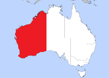
The Western Australian border was originally designated as 129th meridian east longitude (129° east). However, the border marked on the ground is some distance from this line.[1] Kununurra is the closest town to the Western Australian border, being about 25 km west of the border. The closest settlement is Border Village, 1,734 km to the south on the South Australian side of the border, on Eyre Highway.
Border delineation
The Western Australian (WA) border marked on the ground, is not as straight as it looks on a map. The Northern Territory border with Western Australia and the South Australian border with Western Australia are displaced east-west by approximately 127 metres, due to errors within the limits of surveying technology available in the 1920s.[1]
Where Western Australia meets the Northern Territory (NT) and South Australia (SA) borders is a 127-metre segment running east-west along the 26th parallel south latitude (26° south).[1]
In June 1968, two monuments were erected to mark each end of this 127-metre segment, At the easternmost of these concrete border markers all three borders meet, at Surveyor Generals Corner.[1]
History
1788–1825
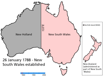
In 1788 Governor Phillip claimed the continent of Australia only as far west as the 135th meridian east (135° east) in accordance with his commission.[2] (26 January 1788 – MAP)
It has been suggested that the 1788 claim by the British of 135° east was in reference to Spain's claims under the Treaty of Tordesillas. Spain was seen as no longer having an interest in the area. On the other hand, the other signatories to the treaty, the Portuguese still had a presence in Macau and East Timor. Adoption of 135° east as a boundary would minimise provocation of the Portuguese. By 1825, however, Britain was powerful enough and found it convenient to adopt the original line of the Portuguese under the treaty, 129° east.[3]
1825–29
The line of 129° east first became a border in Australia as the western border of New South Wales (NSW) in 1825 (16 July 1825 – MAP).
On 16 July 1825, the western boundary of New South Wales was relocated at 129° east to take in the new settlement at Melville Island.[4]
From 1825 to 1829 129° east was the NSW border, except that the settlement of King George's Sound, now Albany, was part of New South Wales from its establishment on 26 December 1826, until 7 March 1831 when it was made part of the Swan River Colony.[5]
1829–32
Following the settlement of the Swan River Colony (SRC) in 1829 (2 May 1829 – MAP), the eastern boundary was declared to be 129° east, that is coinciding with the western boundary of New South Wales at the time.[6]
The Swan River Colony, started in 1829, was commissioned as the colony of Western Australia in March 1831.[7]
From 1829 to 1832 129° east was the SRC/NSW border.
1832–46
The name of the Swan River Colony changed to Western Australia in 1832 (6 February 1832 – MAP).[8]
From 1832 to 1846 129° east was the WA/NSW border.
1846–47
In 1846 the colony of North Australia (NA) was proclaimed by Letters Patent, which was all of New South Wales north of 26° south. (17 February 1846 – Map).[9]
From 1846 to 1847 129° east was the WA/NA border north of 26° south and the WA/NSW border south of the 26th parallel.
1847–60
In 1847 the colony of North Australia was revoked and reincorporated into New South Wales. (15 April 1847 – MAP).[10]
From 1847 to 1860 129° east was once again the WA/NSW border.
1860–63
In 1860 South Australia, which had been proclaimed a colony in 1836 (28 December 1836 – MAP), west to the 132° east, changed their western border from 132° east to 129° east (1860 – MAP).[11]
From 1860 to 1863 129° east was the WA/NSW border north of 26° south and the WA/SA border south of the 26th parallel.
1863–1911
In 1863 that part of New South Wales to the north of South Australia was annexed to South Australia by Letters Patent and became known as the Northern Territory of South Australia (NToSA). (6 July 1863 – MAP).[12]
From 1863 to 1911 129° east was the WA/NToSA border north of 26° south and the WA/SA border south of the 26th parallel
1911–27
In 1911 the Northern Territory (NT) was split off from South Australia to be administered by the Commonwealth. (1 January 1911 – MAP).[13]
From 1911 to 1927 129° east was the WA/NT border north of 26° south and the WA/SA border south of the 26th parallel.
1927–31
In 1927 the Northern Territory was split into two territories, North Australia (NA) and Central Australia (CA). (1 March 1927 – MAP).[14]
From 1927 to 1931 129° east was once again the WA/NA border and WA/CA border, both north of 26° south and the WA/SA border south of the 26th parallel.
1931–present
In 1931 North Australia and Central Australia were reunited as the Northern Territory. (12 June 1931 – MAP).[15]
From 1931 to the present 129° east has been the WA/NT border north of 26° south and the WA/SA border south of the 26th parallel.
Marking the WA border on the ground
History of fixing the border
Fixing the position of the border of Western Australia on the ground has a rich history. In March 1920 the Western Australian Government Astronomer, H. B. Curlewis gave a talk at the WA Museum about the history of the determination of longitude, in relation to using what was at that time a new technology, by using wireless time signals to determine the position of the border between South Australia and Western Australia, as close to the 129th east meridian as possible.[16]
WA/SA border marking history
Preliminary work on the border determinations began in November 1920 when the Government Astronomer for South Australia, G.F. Dodwell and the Government Astronomer of Western Australia, H.B. Curlewis met at Deakin, Western Australia on the East-West Trans-Australian Railway.[17]
The other members of the party were Messrs. Clive Melville Hambidge and J. Crabb, of the Survey Department; Warrant Officer V. D. Bowen, in charge of wireless apparatus lent by the Defence Department; and Mr. C. A. Maddern, of the Adelaide Observatory, all from Adelaide.[17]
Concrete piers for the astronomical observing instruments were erected in readiness for the final determinations that were to be held in 1921. Observations were made for the purpose of testing under field conditions the instruments and methods to be used in 1921.[17]
This expedition, to determine 129° east on the ground, created world-wide scientific interest and involved the cooperation of the Astronomer Royal and the Royal Observatory, Greenwich, with wireless time signals sent by the French wireless Service, that were transmitted from the Lyons astronomical observatory (Observatoire de Lyon) at Saint-Genis-Laval, near Lyons, France, between 17 and 24 November 1920. Wireless time signals were also sent from the Adelaide Observatory, transmitted by the Adelaide Radio Station, to enable the beats of the Adelaide sidereal clock to be used as a control on the rate of the chronometer used for the boundary observation.[17]
After these initial tests a comprehensive program was then arranged for the second stage of the border determinations, which were to take place during the following year and dates were then set for that to happen, from 20 April to 10 May 1921.[17]
Deakin Pillar
One of the concrete piers mentioned, which were cubic concrete blocks slightly smaller than a cubic metre, would later be named as the Deakin Pillar (1921), being from where the larger border marker, the Deakin Obelisk (1926), would be set out from.[1]
Deakin Obelisk
The Deakin Pillar is approximately 2.82 km west of the Deakin Obelisk. The Deakin Obelisk was erected as closely as was possible with the technology of 1926 to 129° east.[1]
The Deakin Obelisk has a copper plug embedded into the top centre of the concrete obelisk, which determines, on the ground, the South Australian border with Western Australia by a line drawn south to the coastline of the Great Australian Bight and north through this point to 26° south.[1]
WA/NT border marking history
Shortly after the 1921 determinations of the border of South Australia and Western Australia, the Government Astronomer for South Australia, G.F. Dodwell and the Government Astronomer of Western Australia, H.B. Curlewis and party travelled by the State Ship Bambra to the port of Wyndham, Western Australia.[18]
From Wyndham they were guided by Michael Patrick ("M.P.") Durack to a point he perceived as the northern boundary between his Argyle Downs Station and Jack Kilfoyle's Rosewood Station, which was also Western Australia's border with the Northern Territory or 129° east.[18] Most of Rosewood station is in the Northern Territory but some distance further south Rosewood also extends into the East Kimberley Region of Western Australia.
From the chosen position, two concrete pillars were erected similar to those described above and portable radio masts set up, before the determinations were carried out by the scientists using the same methods of wireless time signals as were used at Deakin.[18]
Austral Pillar
One of the concrete pillars erected, which was the one used as the point of the determinations, was marked by the expedition party to show how far east of Greenwich they were in hours, minutes and seconds, and became known as the Austral Pillar.[1]
The Austral Pillar, the point selected for the scientific determinations of 1921 would later be found to be about 2 km east from the border of 129° east on that part of Rosewood Station, therefore inside the Northern Territory.[1]
Kimberley Obelisk
The Kimberley Obelisk was erected as closely as was possible with the technology of 1927 to 129° east. Over several weeks during 1927, a Western Australian survey crew from the WA Department of Lands and Surveys travelled to Wyndham, then to the Austral Pillar site to set out from that point to the border, where they then erected the much more substantial Kimberley Obelisk.[1]
The Kimberley Obelisk has a copper plug embedded into the top of the concrete obelisk, which officially determines the WA/NT border on the ground, near 129° east, by a line drawn north to the northern coastline near the Joseph Bonaparte Gulf and south through this point at the Kimberley Obelisk to the 26th parallel.[1]
References
- 1 2 3 4 5 6 7 8 9 10 11 Porter, John, Surveyor-General of South Australia (April 1990). An Historical Perspective – Longitude 129 degrees east, and why it is not the longest, straight line in the world. National Perspectives – 32nd Australian Surveyors Congress Technical Papers 31 March – 6 April 1990. Canberra: The Institution: Eyepiece – Official Organ of The Institution of Surveyors, Australia, W.A. Division (published June 1990). pp. 18–24.
- ↑ "Governor Phillip's Instructions 25 April 1787 (UK)". Documenting a Democracy. National Archives of Australia. Retrieved 2006-05-28.
- ↑ Brown, A. J. (2003). "Chapter two: Union or unity? Anglo-Australian territorial theory to the 1840s" (pdf). The Frozen Continent: The fall and rise of territory in Australian constitutional thought 1815-2003. PhD Thesis]). Griffith University. Retrieved 2006-05-28.
- ↑ Taylor, Peter (1990). "Chapter 10: Government and the States". The Atlas of Australian History. Sydney, New South Wales, Australia: Child & Associates Publishing Pty Ltd. pp. 118–9. ISBN 0-86777-429-0.
- ↑ "King George's Sound Settlement". State Records. State Records Authority of New South Wales. Retrieved 14 May 2014.
- ↑ "Transcript of Commission appointing Stirling Governor and Commander-in-Chief 4 March 1831 (UK)" (pdf). Documenting a Democracy. National Archives of Australia. Retrieved 2006-05-28.
- ↑ "Commission appointing Stirling Governor and Commander-in-Chief 4 March 1831 (UK)". Documenting a Democracy. National Archives of Australia. Retrieved 2006-05-28. found cited in Territorial evolution of Australia – 6 February 1832
- ↑ Cited in Territorial evolution of Australia – 6 February 1832
- ↑ Cited in Territorial evolution of Australia – 17 February 1846
- ↑ Cited in Territorial evolution of Australia – 15 April 1847
- ↑ Cited in Territorial evolution of Australia – 1860
- ↑ Cited in Territorial evolution of Australia – 6 July 1863
- ↑ Cited in Territorial evolution of Australia – 1 January 1911
- ↑ Cited in Territorial evolution of Australia – 1 March 1927
- ↑ Cited in Territorial evolution of Australia – 12 June 1931
- ↑ "ROYAL SOCIETY.". The West Australian. Perth: National Library of Australia. 17 March 1920. p. 7. Retrieved 9 January 2012.
- 1 2 3 4 5 "FIXING A BOUNDARY.". The Advertiser. Adelaide: National Library of Australia. 6 December 1920. p. 7. Retrieved 9 January 2012.
- 1 2 3 "1921 WA-NT Border Determinations". Kununurra Historical Society Inc. Retrieved 9 January 2012.
See also
- South Australia-Victoria border dispute
- Greenwich Time Signal
- Surveyor General
- Surveyor General of Western Australia