Northern Yatsugatake Volcanic Group
| Northern Yatsugatake Volcanic Group | |
|---|---|
| 北八ヶ岳 Kita-Yatsugatake | |
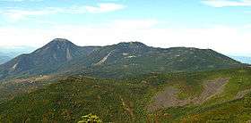 Mount Shibagare, Mount Yoko, and Mount Tateshina (October 2006) | |
| Highest point | |
| Peak | Mount Tengu |
| Elevation | 2,646 m (8,681 ft) |
| Coordinates | 36°01′09″N 138°21′20″E / 36.01917°N 138.35556°ECoordinates: 36°01′09″N 138°21′20″E / 36.01917°N 138.35556°E |
| Naming | |
| Etymology | Northern Mountains with eight peaks |
| Geography | |
| Country | Japan |
| State | Nagano Prefecture |
| Region | Chūbu |
| Districts | Kitasaku and Minamisaku District, Nagano |
| Parent range | Yatsugatake Mountains |
| Borders on | Southern Yatsugatake Volcanic Group |
| Biome | Alpine climate |
| Geology | |
| Orogeny | Island arc |
| Age of rock | Quaternary |
| Type of rock | Volcanic |
Northern Yatsugatake Volcanic Group (北八ヶ岳 Kita-Yatsugatake) is a volcanic group of stratovolcanoes and lava domes[1] located in Nagano Prefecture on Honshū in Japan.
Description
The Northern Yatsugatake Volcanic Group is part of the Yatsugatake Mountains. The northern group is defined as the mountains from Mount Futago to Natsuzawa Pass. The highest peak of the mountains is Mount Tengu and the elevation is 2,646 metres.
The southern Yatsugatake mountains are steep and have alpine characteristics. The mountains of the Northern Yatsugatake Volcanic Group are gentler and lower.
Yatsugatake is listed among the 100 famous mountains in Japan, but this refers to the Southern Yatsugatake Volcanic Group. Mount Tateshina is also mentioned as one of the 100 famous mountains, and it is part of the Northern Yatsugatake mountains, but is listed separately.
These mountains are part of the Yatsugatake-Chūshin Kōgen Quasi-National Park.[2]
Geology and volcanic activity
The volcanoes are stratovolcanos that are 1 million to 200,000 years old. The rock is mainly basalt, dacite, and andesite. Mount Yoko has shown the most recent activity and is now considered an active volcano. It last erupted about 800 years ago.[3] In 888 a debris avalanche on the East side of the volcanic massif caused Lake Matsubara to form. The Tateshina-kogen plateau was formed by a large lava flow.[1]
List of peaks
The following peaks, from North to South, make up the Northern Yatsugatake Volcanic Group:[1][3]
- Mount Futago, cinder cone
- Mount Tateshina (Also known as Suwa Fuji.[1]), stratovolcano
- Mount Yoko (Also known at Mount Kita Yoko.), lava dome
- Mount Shimagare, lava dome
- Mount Chausu, lava dome
- Mount Maru
- Nyu
- Mount Naka
- Mount Tengu
- Mount Neishi
References
| Wikimedia Commons has media related to Mt. Yatsugatake. |
- 1 2 3 4 "Kita Yatsuga-take". Global Volcanism Program. Smithsonian Institution. Retrieved 2008-08-28.
- ↑ 八ヶ岳中信高原国定公園. Japan Integrated Biodiversity Information System (in Japanese). Ministry of the Environment, Government of Japan. Retrieved 2008-09-05.
- 1 2 "KITA YATSU-GA-TAKE (TATESHINA-YAMA, YOKO-DAKE etc.)". Quaternary Volcanoes of Japan. Geological Survey of Japan, AIST. 2006. Retrieved 2008-08-23.
Gallery
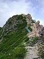 Mount Higashi-Tengu, the highest peak of the Kita-Yatsugatake Mountains
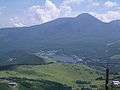 Mount Tateshina from Lake Shirakaba