Norwood Avenue (BMT Jamaica Line)
| Norwood Avenue | |||||||||||
|---|---|---|---|---|---|---|---|---|---|---|---|
| New York City Subway rapid transit station | |||||||||||
 | |||||||||||
| Station statistics | |||||||||||
| Address |
Norwood Avenue & Fulton Street Brooklyn, NY 11208 | ||||||||||
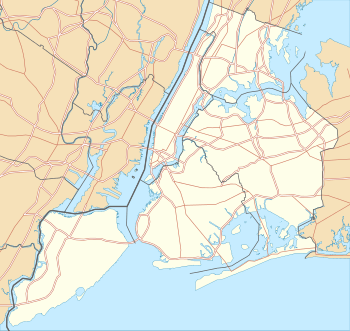
| Borough | Brooklyn | ||||||||||
| Locale | Cypress Hills | ||||||||||
| Coordinates | 40°40′54″N 73°52′45″W / 40.681582°N 73.879151°WCoordinates: 40°40′54″N 73°52′45″W / 40.681582°N 73.879151°W | ||||||||||
| Division | B (BMT) | ||||||||||
| Line | BMT Jamaica Line | ||||||||||
| Services |
J Z | ||||||||||
| Transit connections |
| ||||||||||
| Structure | Elevated | ||||||||||
| Platforms | 1 island platform | ||||||||||
| Tracks | 2 | ||||||||||
| Other information | |||||||||||
| Opened | May 30, 1893[1] | ||||||||||
| Traffic | |||||||||||
| Passengers (2015) |
1,159,274[2] | ||||||||||
| Rank | 346 out of 422 | ||||||||||
| Station succession | |||||||||||
| Next north |
Crescent Street: J | ||||||||||
| Next south |
Cleveland Street: J (Z | ||||||||||
| |||||||||||
| |||||||||||


Norwood Avenue is a skip-stop station on the BMT Jamaica Line of the New York City Subway. Located at the intersection of Norwood Avenue and Fulton Street in Cypress Hills, Brooklyn,[3] it is served by the Z train during rush hours in peak direction and the J at all other times.[4]
History
This station was opened on May 30, 1893 as part of a four stop extension of the Lexington Avenue Line to Cypress Hills.[1]
From July 18, 2005 to March 13, 2006 this station was closed in order to undergo a station rehabilitation. As part of the rehabilitation project, the stairs were rehabilitated, the floors were renewed, major structural repairs were made, new canopies were installed, the area around the station booth was reconfigured, the platform edge strips were replaced, walls were replaced, and a high-quality public address system was installed.[5][6]
Station layout
| P Platform level |
Southbound | ← ← |
| Island platform, doors will open on the left | ||
| Northbound | → → | |
| M | Mezzanine | Fare control, station agent |
| G | Street Level | Exit / Entrance |
This elevated station has two tracks and one island platform.[7] The platform has a short red canopy with green frames and support columns at the east (railroad north) end and silver lampposts and black station sign structures for the rest of the length.
The station's only entrance/exit is a station house connected to the platform at the extreme east end. It has a bank of three turnstiles, token booth, and one staircase going down to an elevated passageway beneath the tracks, where two staircases go down to either eastern corners of Norwood Avenue and Fulton Street.[3]
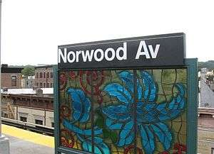
The 2007 artwork here is called "Culture Swirl" by Margaret Lazetta, It consists of stained glass artwork of various images on the platform sign structures.[8][9]
Between here and Crescent Street, the remains of a former connection to the Long Island Rail Road's Atlantic Avenue Branch one block to the south of the BMT Jamaica Line can be seen at Chestnut Street. In the 1890s, the railroad wanted access to Manhattan while the Brooklyn Rapid Transit company wanted access to The Rockaways. Due to the close proximity of the two lines, the companies cooperated on a connection beginning in 1898. The LIRR ran service to Broadway Ferry while BRT ran service to the Rockaways via Woodhaven Junction. When the Williamsburg Bridge opened, LIRR service was extended to Essex Street and later Chambers Street. This was the LIRR's first direct access to Manhattan.
In 1917, the United States Railroad Administration ruled that a commuter railroad line cannot operate on the same tracks with a subway or elevated line, requiring this connection to be severed. Most of the junction's structure remained until the 1940s when it was dismantled so the steel could be used in World War II and the Atlantic Avenue Branch was moved underground.
References
- 1 2 "Trains Running This Morning The Elevated Road to Cypress Hills Still in Operation". The Brooklyn Daily Eagle. May 30, 1893. p. 10. Retrieved October 2, 2016 – via Brooklyn Newspapers.
- ↑ "Facts and Figures: Annual Subway Ridership". Metropolitan Transportation Authority. Retrieved 2016-04-19.
- 1 2 "Neighborhood Map East New York Cypress Hills Woodhaven New Lots" (PDF). mta.info. Metropolitan Transportation Authority. 2015. Retrieved October 2, 2016.
- ↑ "J/Z Subway Timetable, Effective November 7, 2016" (PDF). New York Metropolitan Transportation Authority. Retrieved November 7, 2016.
- ↑ "Norwood Av station closed for rehabilitation Beginning 12:01 AM Mon, Jul 18 to 5 AM, Mon, Jan 16, 2006" (PDF). mta,info. Metropolitan Transportation Authority. 2005. Retrieved October 2, 2016.
- ↑ "Norwood Av station remains closed The station will reopen 12: 01 AM Mon, Mar 13." (PDF). mta.info. Metropolitan Transportation Authority. March 2006. Retrieved October 2, 2016.
- ↑ Marrero, Robert (2015-09-13). "469 Stations, 846 Miles" (PDF). B24 Blog, via Dropbox. Retrieved 2015-10-09.
- ↑ "www.nycsubway.org: Artwork: Culture Swirl (Margaret Lanzetta)". www.nycsubway.org. Retrieved 2016-10-02.
- ↑ "MTA - Arts & Design | NYCT Permanent Art". web.mta.info. Retrieved 2016-10-02.
External links
- nycsubway.org – BMT Jamaica Line: Norwood Avenue
- Station Reporter — J Train
- The Subway Nut — Norwood Avenue Pictures
- MTA's Arts For Transit — Norwood Avenue (BMT Jamaica Line)
- Norwood Avenue entrance from Google Maps Street View