Ohio State Route 562
| ||||
|---|---|---|---|---|
| Norwood Lateral Expressway | ||||
 | ||||
| Route information | ||||
| Maintained by ODOT | ||||
| Length: | 3.43 mi[1] (5.52 km) | |||
| Existed: | 1938 – present | |||
| Major junctions | ||||
| West end: |
| |||
|
| ||||
| East end: |
| |||
| Location | ||||
| Counties: | Hamilton | |||
| Highway system | ||||
| ||||

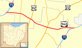
State Route 562 is an expressway in the Cincinnati metro area of southwestern Ohio. It travels east–west between Interstate 75 and Interstate 71, crossing through the suburban enclave of Norwood. It is generally locally referred to as the Norwood Lateral Expressway.
Route description
The entire length of SR 562 in Ohio is included as a part of the National Highway System (NHS).[2] The NHS is a network of highways that are identified as being most important for the economy, mobility and defense of the nation.[3]
SR 562 heads east from I–75, just north of St. Bernard. The road has an interchange with SR 4 and U.S. Route 42 near Bond Hill. The route then has an interchange with US 22/SR 3 near Norwood. Before the eastern terminus at I-71, the road pass under two different railroad tracks. The eastern terminus of the highway is at a full interchange with I-71.[4]
History
State Route 562 (the Norwood Lateral) was completed in 1962.[5]
Future
The road is proposed to become I-74 as part of its extension to South Carolina.
Major intersections
The entire route is in Cincinnati, Hamilton County.
| mi[1] | km | Exit | Destinations | Notes | |
|---|---|---|---|---|---|
| 0.00 | 0.00 | Western terminus of SR 562 | |||
| 0.65 | 1.05 | 1 | |||
| 1.21 | 1.95 | 2 | |||
| 2.11 | 3.40 | 3 | |||
| 3.43 | 5.52 | Eastern terminus of SR 562 | |||
| 1.000 mi = 1.609 km; 1.000 km = 0.621 mi | |||||
References
- 1 2 Ohio Department of Transportation. "Technical Services Straight Line Diagrams". Retrieved March 23, 2012.
- ↑ National Highway System: Cincinnati, Ohio (PDF) (Map). Federal Highway Administration. December 2003. Retrieved March 29, 2012.
- ↑ "National Highway System". Federal Highway Administration. August 26, 2010. Retrieved March 29, 2012.
- ↑ Google (March 29, 2012). "Overview of SR 562 in Ohio" (Map). Google Maps. Google. Retrieved March 29, 2012.
- ↑ Singer, Allen J. (2003). The Cincinnati Subway. Arcadia Publishing. p. 103. Retrieved 2013-06-21.