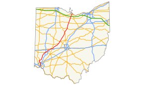
Ohio State Route 4
| |||||||
|---|---|---|---|---|---|---|---|
 | |||||||
| Route information | |||||||
| Maintained by ODOT | |||||||
| Length: | 206.51 mi[1] (332.35 km) | ||||||
| Existed: | 1912 – present | ||||||
| Major junctions | |||||||
| South end: |
| ||||||
|
| |||||||
| North end: |
| ||||||
| Location | |||||||
| Counties: | Hamilton, Butler, Montgomery, Greene, Clark, Champaign, Union, Delaware, Marion, Crawford, Seneca, Huron, Erie | ||||||
| Highway system | |||||||
| |||||||


State Route 4 (SR 4), formerly known as Inter-county Highway 4 until 1921[2] and State Highway 4 in 1922,[3] is a major north–south state highway in Ohio. It is the fifth longest state route in Ohio. Its southern terminus is at U.S. Route 42 in Cincinnati, Ohio, and its northern terminus is at U.S. Route 6 in Sandusky, Ohio. Its path is nearly ruler-straight for many miles. Some portions of the route are still marked as Dixie Highway. The northern portion was constructed by the Columbus and Sandusky Turnpike Company, see Turnpike Lands.
Route description
State Route 4 begins in Cincinnati, running through Dayton, then joining Interstate 70, with which it runs concurrently for over three miles. The route then goes through Springfield and continues to Marion. It then travels to Bucyrus, finally heading northeast to Sandusky, where it ends.
History
- 1912 – Route ran from Sandusky to Columbus
- 1924 – Route extended south from Columbus on former SH 5, following current US 23 alignment from Portsmouth to Waldo, and current SR 423 from Waldo to Marion.[4]
- 1926 – Alignment from Portsmouth to Marion certified as US 23; SR 4 realigned south of Marion to its current southern terminus in Cincinnati, replacing the former SR 6 from Cincinnati to Middletown, the former SR 52 from Middletown to 3 miles (4.8 km) south of Milford Center, and the former SR 38 from Marysville to Marion.[4]
- 1959 – Alignment from Dayton to Springfield rerouted and upgraded to freeway; segment through Fairborn around Wright-Patterson Air Force Base designated as SR 444.[4]
- 1967 – Segment from SR 201 to SR 444 upgraded to freeway.[4]
- 2011 – Dayton segment is rerouted via I-75
Major intersections
| County | Location | mi | km | Exit | Destinations | Notes |
|---|---|---|---|---|---|---|
| Hamilton | Cincinnati | 0.0 | 0.0 | Southern terminus at a signalized intersection. | ||
| 1.2 | 1.9 | Full-access interchange with expressway. | ||||
| 2.5 | 4.0 | |||||
| 2.7 | 4.3 | Full-access interchange; I-75 Exit 9. | ||||
| Woodlawn | 7.1 | 11.4 | Glendale Milford Road | Former routing of SR 126 | ||
| 7.5 | 12.1 | Southern terminus of SR 747. | ||||
| Springdale | 9.4 | 15.1 | West Kemper Road | Former routing of SR 126 | ||
| 10.0 | 16.1 | Full-access interchange; I-275 Exit 41. | ||||
| Butler | Fairfield | 12.4 | 20.0 | Southern terminus of bypass route. | ||
| Hamilton | 18.5 | 29.8 | ||||
| Fairfield Township | 21.2 | 34.1 | Northern terminus of bypass route. | |||
| Liberty Township | 24.3 | 39.1 | Northern terminus of SR 747. | |||
| Lemon Township | 26.3 | 42.3 | Western terminus of SR 63. | |||
| 28.2 | 45.4 | South Main Street | Former routing of SR 4 | |||
| 28.7 | 46.2 | SR 73 joins from the west. | ||||
| Middletown | 31.3 | 50.4 | ||||
| 31.9 | 51.3 | Tytus Avenue | Former routing of SR 4 | |||
| 32.8 | 52.8 | SR 73 leaves to the east; former southbound alignment of SR 4. | ||||
| Madison Township | 34.6 | 55.7 | Middletown Germantown Road | Former routing of SR 4 | ||
| Montgomery | German Township | 38.9 | 62.6 | Western terminus of SR 123. | ||
| Germantown | 39.9 | 64.2 | SR 725 joins from the west. | |||
| 40.5 | 65.2 | Dayton Pike | Former routing of SR 4 | |||
| 41.5 | 66.8 | SR 725 leaves to the east. | ||||
| Dayton | Southern end of I-75 concurrency; exit 52 on I-75 | |||||
| Bridge over the Great Miami River | ||||||
| 53A | ||||||
| 53B | ||||||
| Bridge over the Great Miami River | ||||||
| 54A | Grand Avenue, Riverside Drive | Closed; southbound originally had separate ramp to Riverside Drive which was later removed; access consolidated with newly built Main Street exit as part of I-75 Downtown Modernization[5] | ||||
| 54A | Also formerly exit 54B | |||||
| Bridge over the Great Miami River | ||||||
| — | Northern terminus of I-75 concurrency; exit 54B on I-75 | |||||
| — | Webster Street / Keowee Street (north) | northbound exit | ||||
| — | Webster Street / Keowee Street (south) | northbound exit; southbound entrance | ||||
| 54.5 | 87.7 | — | northbound exit and entrance; southbound exit | |||
| — | Findlay Street / Stanley Avenue | Separate exits on northbound side | ||||
| — | Harshman Road | |||||
| 59.2 | 95.3 | — | former eastbound alignment of SR 4. | |||
| Northern end of freeway | ||||||
| Huber Heights | 63.2 | 101.7 | SR 235 joins from east via full-access interchange. | |||
| 64.6 | 104.0 | I-70 joins from the west; SR 235 leaves to the north; full-access interchange; I-70 Exit 41A-B. | ||||
| Clark | Mad River Township | 67.8 | 109.1 | 44 | Full-access interchange; northern terminus of I-675; I-675 Exit 26A-B. | |
| 70.5 | 113.5 | Northern end of I-70 concurrency; Exit 47 eastbound and Exit 48 westbound (via Enon Road) on I-70 | ||||
| Bethel Township | — | Enon / Donnelsville | ||||
| 73.2 | 117.8 | — | Southern terminus of SR 369; former cross-alignment of SR 4. | |||
| Springfield Township | — | Lower Valley Pike | Southbound exit; northbound entrance | |||
| 76.0 | 122.3 | Southbound exit; northbound entrance | ||||
| Northern end of freeway | ||||||
| 76.4 | 123.0 | Full-access interchange with US 68 | ||||
| Springfield | 78.5 | 126.3 | SR 41 joins from the north. | |||
| 79.0 | 127.1 | Southbound lanes of SR 72; northbound lanes 0.1 miles (0.16 km) later. | ||||
| 79.6 | 128.1 | US 40/SR 41 concurrency leaves SR 4 to the east. | ||||
| Moorefield Township | 84.3 | 135.7 | Eastern terminus of SR 334. | |||
| 85.6 | 137.8 | Old Mechanicsburg Road | Former routing of SR 4 | |||
| 87.9 | 141.5 | Old Mechanicsburg Road | Former routing of SR 4 | |||
| Champaign | Union Township | 90.8 | 146.1 | |||
| 93.7 | 150.8 | |||||
| Mechanicsburg | 96.9 | 155.9 | ||||
| Goshen Township | 100.9 | 162.4 | SR 161 joins from the southwest. | |||
| Union | Union Township | 102.3 | 164.6 | SR 161 leaves to the southeast. | ||
| 104.3 | 167.9 | US 36 joins from the northwest. | ||||
| Paris Township | 110.1 | 177.2 | Milford Avenue | Former routing of SR 4 | ||
| 112.1 | 180.4 | US 33 expressway joins from the west; expressway concurrency continues northeast. | ||||
| 112.5 | 181.1 | — | Eastern terminus of SR 245; former cross-alignment of US 33. | |||
| Marysville | 114.1 | 183.6 | — | Southern terminus of SR 31; former cross-alignment. | ||
| Paris Township | 114.9 | 184.9 | SR 4 leaves expressway via full-access interchange; expressway continues southeast; northern terminus of SR 38; former southbound alignment of SR 4. | |||
| Leesburg Township | 122.0 | 196.3 | ||||
| 124.9 | 201.0 | SR 37 joins from the southeast. | ||||
| Claibourne Township | 125.9 | 202.6 | SR 37 leaves to the west. | |||
| Delaware | Thompson Township | 129.9 | 209.1 | SR 47 joins from the west. | ||
| Marion | Prospect Township | 130.6 | 210.2 | SR 47 leaves to the east. | ||
| 133.4 | 214.7 | |||||
| Marion | 140.7 | 226.4 | Southbound lanes of SR4/SR 423 concurrency | |||
| 140.9 | 226.8 | SR 423 continues to the south | ||||
| 141.1 | 227.1 | Eastern terminus of SR 739. | ||||
| 141.4 | 227.6 | Junction with eastbound lanes; westbound lanes 0.1 mi. later. | ||||
| Marion Township | 143.7 | 231.3 | SR 423 leaves to the north. | |||
| Grand Prairie Township | 147.0 | 236.6 | Full-access interchange with US 23 expressway. | |||
| Crawford | Dallas Township | 151.8 | 244.3 | |||
| Bucyrus | 158.8 | 255.6 | SR 98 joins from the south. | |||
| 159.5 | 256.7 | SR 19 and SR 100 join from the east | ||||
| 159.9 | 257.3 | SR 98 leaves to the northeast. | ||||
| Holmes Township–Bucyrus municipal line | 160.7 | 258.6 | Full-access interchange with US 30 expressway. | |||
| 161.2 | 259.4 | SR 19/SR 100 concurrency leaves to the west. | ||||
| Chatfield | 169.4 | 272.6 | SR 103 joins from the west. | |||
| Chatfield Township | 170.5 | 274.4 | SR 103 leaves to the east. | |||
| Seneca | Attica | 177.8 | 286.1 | |||
| Reed Township | 182.2 | 293.2 | ||||
| Huron | Sherman Township | 185.8 | 299.0 | Southern terminus of SR 269, which straddles the Seneca-Huron county line. | ||
| 187.9 | 302.4 | |||||
| Lyme Township | 192.5 | 309.8 | ||||
| 193.8 | 311.9 | |||||
| Erie | Groton Township | 198.1 | 318.8 | SR 4 passes over Turnpike here; access ramps are 0.3 mi. later; Turnpike Exit 110. | ||
| 198.8 | 319.9 | Northern terminus of SR 99. | ||||
| Perkins Township | 202.6 | 326.1 | Full-access interchange with SR 2 expressway. | |||
| Sandusky | 206.4 | 332.2 | Northern terminus of SR 101; eastern terminus of US 6/SR 101 concurrency; US 6 continues east. | |||
1.000 mi = 1.609 km; 1.000 km = 0.621 mi
| ||||||
State Route 4 Bypass
| |
|---|---|
| Location: | Hamilton, Ohio |
| Existed: | 1971–present |
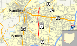
State Route 4 By-Pass (SR 4B or SR 4 Bypass) is a 5.97-mile-long (9.61 km)[6] north–south state highway through Butler County in the western part of the state. The route runs from SR 4 in Fairfield to SR 4 in Fairfield Township north of the Hamilton city limits.
SR 4B begins at a quadrant roadway intersection with SR 4 (Dixie Highway) and Ross Road in eastern Fairfield. Here, the connector road is located in the northwest quadrant of the intersection. The route travels north as a divided four-lane road first crossing over a CSX railroad and intersecting Port Union Road. The next three intersections SR 4B has (from south to north Symmes Road, Tylersville Road, and Hamilton Mason Road) are superstreet intersections that opened in 2012. The roadway briefly expands to three lanes in each direction between Symmes Road and Tylersville Road as it crosses over a Norfolk Southern railroad. This segment also features the Fairfield-Hamilton city boundary. After the Hamilton Mason Road intersection, SR 4B comes to a diamond interchange with SR 129 (Butler County Veterans Highway). North of Hamilton Princeton Road, the route shrinks to an undivided two-lane road, passes under an overpass carrying Milliken Road, and ends at a signalized intersection with SR 4.[7] The entirety of SR 4B is included as a part of the National Highway System.[8]
SR 4B was constructed in the early 1970s by ODOT to allow for easier travel between Cincinnati and Middletown.[9][10][11] In the 1990s, the Butler County Transportation Improvement District (BCTID) was formed to help address traffic congestion along the fully two-lane bypass route. Construction started on the widening of SR 4B in 2010 which included the widening of the road from the southern terminus to SR 129, the widening of three bridges, and the creation of three superstreet and one quadrant roadway intersections.[9] Construction of the expanded roadway finished in August 2012 and the BCTID is continuing to study the option of widening SR 4B north of SR 129.[12]
Major junctions
The entire route is in Butler County.
| Location | mi[6] | km | Destinations | Notes | |
|---|---|---|---|---|---|
| Fairfield | 0.00 | 0.00 | |||
| Fairfield Township | 4.35 | 7.00 | Interchange | ||
| 5.97 | 9.61 | ||||
| 1.000 mi = 1.609 km; 1.000 km = 0.621 mi | |||||
References
| Wikimedia Commons has media related to Ohio State Route 4. |
- ↑ Ohio Department of Transportation. "Technical Services Straight Line Diagrams". Retrieved January 5, 2014.
- ↑ Ohio Department of Highways and Public Works (September 1921). Highway Map of Ohio (Map). Columbus: Ohio Department of Highways and Public Works.
- ↑ Ohio Department of Highways and Public Works (April 1922). Map of Ohio State Highways (MrSID) (Map). Columbus: Ohio Department of Highways and Public Works.
- 1 2 3 4 Route 4 (The Unofficial Ohio State Highways Web Site) by John Simpson Archived October 30, 2004, at the Wayback Machine.
- ↑ Staff. "Modernization of I-75 through Downtown Dayton: I-75 and SR 4 Phase 1A & Stanley Avenue". Ohio Department of Transportation.
- 1 2 ODOT. "Technical Services Straight Line Diagrams: SR 4-B, Butler County" (PDF). Retrieved January 5, 2014.
- ↑ Google (January 5, 2014). "Overview of SR 4-B" (Map). Google Maps. Google. Retrieved January 5, 2014.
- ↑ National Highway System: Ohio (PDF) (Map). Federal Highway Administration. October 2012. Retrieved January 5, 2014.
- 1 2 "State Route 4 Bypass Widening". Butler County Transportation Improvement District. November 17, 2010. Retrieved January 5, 2014.
- ↑ 1969 Official Ohio Highway Map (MrSID) (Map). Cartography by P.E. Masheter, Director. Ohio Department of Highways. 1969. Retrieved September 22, 2013.
- ↑ 1971 Ohio Highway Map (MrSID) (Map). Cartography by J. Phillip Richley, Director. ODOH. 1971. Retrieved August 19, 2013.
- ↑ "Bypass 4 Widening Project Overview". Bypass 4 - The City of Fairfield. Retrieved January 5, 2014.