Nouadhibou
| Nouadhibou نواذيبو | |
|---|---|
| Commune and town | |
|
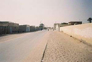
A street in Nouadhibou | |
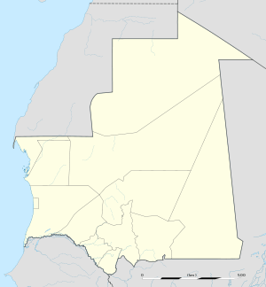 Nouadhibou Location in Mauritania | |
| Coordinates: 20°56′N 17°2′W / 20.933°N 17.033°WCoordinates: 20°56′N 17°2′W / 20.933°N 17.033°W | |
| Country |
|
| Region | Dakhlet Nouadhibou Region |
| Elevation | 0 m (0 ft) |
| Population (2013 census) | |
| • Total | 118,167 |
Nouadhibou (Arabic: نواذيبو; formerly Port-Étienne) is the second largest city in Mauritania and serves as a major commercial centre. The city itself has about 118,000 inhabitants expanding to over 140,000 in the larger metropolitan area, a total of nearly 95% of the entire regional population and is the country's economic capital. It is situated on a 65-kilometre peninsula or headland called Ras Nouadhibou, Cap Blanc, or Cabo Blanco, of which the western side, with the city of La Güera, is part of Western Sahara. Nouadhibou is consequently located merely a couple of kilometers from the border between Mauritania and Western Sahara. Its current mayor is Mohamed Fadel ould Aboubekrine.
Overview
The city is divided into four major areas: the city centre, including the airport; Numerowatt to the north; Cansado, the main residential area, to the south; and a dormitory town for Port Minéralier in the far south, from which iron ore mined in Zouerat is exported.
Attractions in Nouadibou include the Table Remarquable, several markets, a ships' graveyard and Mediterranean monk seals.
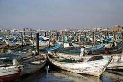
The port of Nouadhibou is the final resting place of over 300 ships and hence the world’s largest ship graveyard. Unlike the arrival en masse of ships at Mallows Bay, here the number of craft has built up over time, as corrupt officials accepted bribes from boat owners to allow them to dump their vessels in the area.
The major economic activity is fishing; however, the largest industry is processing iron ore that is transported by train from the interior mining towns of Zouérat and Fdérik.
History
The town was founded on 15 August 1907 by the governor general of French West Africa Ernest Roume, it was named after the former French Minister of the Colonies Eugène Étienne.[1] Later it became the chief town of the Arguin Bay area replacing Arguin (also known as Agadir). After Mauritania became independent in 1960, the town name changed to Nouadhibou and its cape and bay were also renamed to Nouadhibou.
On 30 June 1973, at the time of the second-longest solar eclipse in the 20th century, an Aerobee rocket was launched at Nouadhibou for solar research.[2]
From February 2006 onwards Nouadhibou has become the departure point for African migrants trying to reach the Canary Islands. This extremely dangerous route to reach the European Union has become popular as a result of increased emigration controls along the Moroccan coast and around the Spanish enclaves of Ceuta and Melilla in the second half of 2005.
The city is reputedly also a centre of trading of meteorites found in the Sahara.[3]
Between 2010 and 2013, the city experienced a huge population growth which added 40,000 or around 50% to the population.
Population history
- 2000: 72,337
- 2013: 118,187
Climate
| Climate data for Nouadhibou, Mauritania | |||||||||||||
|---|---|---|---|---|---|---|---|---|---|---|---|---|---|
| Month | Jan | Feb | Mar | Apr | May | Jun | Jul | Aug | Sep | Oct | Nov | Dec | Year |
| Record high °C (°F) | 32 (90) |
35 (95) |
37 (99) |
37 (99) |
37 (99) |
38 (100) |
37 (99) |
38 (100) |
38 (100) |
38 (100) |
37 (99) |
34 (93) |
38 (100) |
| Average high °C (°F) | 24.5 (76.1) |
25.1 (77.2) |
26.1 (79) |
25.9 (78.6) |
26.3 (79.3) |
27.9 (82.2) |
27.1 (80.8) |
28.2 (82.8) |
30.6 (87.1) |
30.3 (86.5) |
27.5 (81.5) |
24.6 (76.3) |
27.0 (80.6) |
| Daily mean °C (°F) | 18.9 (66) |
19.4 (66.9) |
20.2 (68.4) |
20.3 (68.5) |
21.0 (69.8) |
22.4 (72.3) |
22.8 (73) |
23.9 (75) |
25.3 (77.5) |
24.5 (76.1) |
22.0 (71.6) |
19.4 (66.9) |
21.7 (71.1) |
| Average low °C (°F) | 13.3 (55.9) |
13.7 (56.7) |
14.3 (57.7) |
14.7 (58.5) |
15.8 (60.4) |
17.0 (62.6) |
18.6 (65.5) |
19.6 (67.3) |
20.1 (68.2) |
18.7 (65.7) |
16.5 (61.7) |
14.3 (57.7) |
16.4 (61.5) |
| Record low °C (°F) | 7 (45) |
10 (50) |
12 (54) |
12 (54) |
12 (54) |
15 (59) |
17 (63) |
17 (63) |
16 (61) |
15 (59) |
10 (50) |
5 (41) |
5 (41) |
| Average precipitation mm (inches) | 1 (0.04) |
2 (0.08) |
1 (0.04) |
0 (0) |
0 (0) |
0 (0) |
1 (0.04) |
3 (0.12) |
5 (0.2) |
3 (0.12) |
2 (0.08) |
0 (0) |
18 (0.71) |
| Average precipitation days | 2 | 1 | 1 | 1 | 1 | 1 | 1 | 2 | 2 | 2 | 1 | 1 | 16 |
| Source: | |||||||||||||
Transportation
Paved roads
Nouadhibou is linked with the Coastal Motorway RN2 to the capital Nouakchott (a distance of 450 km) and by highway to the Moroccan border in the north (a distance of 70 km).
Railway
Nouadhibou also is connected by railway to the iron mines in Zouérat, 670 km to the east. The freight trains can be as long as 3 km, reputedly the longest in the world. The railway also carries passengers and calls at Choum.
Aviation
The city is served by Nouadhibou Airport.
Economy
Plans were drawn up at the beginning of 1963 to build a port called Port Wharf in the fishing harbour, which included the construction of industrial and trade buildings. This became operational in 1966. This wharf was designed to accommodate traffic of up to 50,000 tonnes. In 1977 the wharf was lengthened to provide 3 extra berths for ships of average tonnage raising its capacity to 320,000 tonnes.
Sports
The most popular football club is FC Nouadhibou, another club is ASC Snim both inside the Mauritanian Premier League as of the 2014/15 season.
References
- ↑ Jean Abel Gruvel, Les pêcheries des côtes du Sénégal et des rivières du Sud, A. Challamel, Paris, 1908, p. 13 ISBN 2-11-091134-4
- ↑ http://www.astronautix.com/sites/nouhibou.htm
- ↑ "Meteorite smugglers anger scientists". BBC. London. 2007-04-16. Retrieved 2007-06-23.
External links
| Wikimedia Commons has media related to Nouadhibou. |
| Wikivoyage has a travel guide for Nouadhibou. |