November 2016 Vietnam tropical depression
| Tropical depression (JMA scale) | |
|---|---|
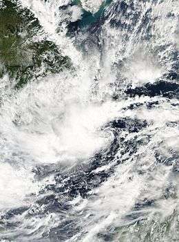 The tropical depression near the southern coast of Vietnam on November 4 | |
| Formed | November 3, 2016 |
| Dissipated | November 6, 2016 |
| Highest winds |
10-minute sustained: 55 km/h (35 mph) |
| Lowest pressure | 1004 hPa (mbar); 29.65 inHg |
| Fatalities | 15 confirmed, 6 missing |
| Damage | $48 million (2016 USD) |
| Areas affected | Borneo, Vietnam, Cambodia |
| Part of the 2016 Pacific typhoon season | |
The November 2016 Vietnam tropical depression was a tropical depression that caused heavy flooding throughout central and southern Vietnam in early November 2016. Forming out from a low-pressure system on November 3, the JMA began monitoring it as a tropical depression. With favorable environments and an increase of organization, the JMA predicted that it had a chance of becoming a tropical storm while the JTWC in the same time issued a Tropical Cyclone Formation Alert on November 4. Due to its proximity to land and a very exposed center, both agencies canceled their warnings as it made landfall over in Southern Vietnam. The system continued moving westward over land and fully dissipated on November 6.
Although the system did not reach tropical storm intensity, the system helped contribute to worsen the effects from the flooding that occurred during mid October. Reports after the storm had stated that a total of 15 people were dead while 6 are still missing. Large areas of cropland were inundated by the waters and numerous homes were damaged. Damages from the system were estimated at ₫1.07 trillion ($48 million USD).[1] Some say that Vietnam had its worst flooding since 2011.[2]
Meteorological history
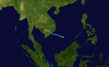
On November 3, the JMA started to track a tropical depression with winds of 55 km/h (35 mph) that had just formed as an area of low-pressure off the coast of the region of Sabah, Malaysia.[3] By November 4, the JTWC started to track the disturbance, giving it a "low" chance of strengthening further, as it was located about 343 km (213 mi) east of Ho Chi Minh City. The reason behind this was the system had a rapidly consolidating low-level circulation center and flaring convection and in the same time, was located in an area of low to moderate wind shear, very warm sea-surface temperatures and good divergence aloft.[4]
Later that day, the JMA had analysed that the tropical depression had reached its maximum intensity with a minimum barometric pressure of 1000 mbar.[5] About two hours later, the JTWC issued a Tropical Cyclone Formation Alert (TCFA), still stating a rapidly consolidating system over in warm waters of 29°C (84.2°F).[6] Though during the next day, the JTWC cancelled their alert due to the fact that the system was weakening and nearing land with increasing wind shear. The depression made landfall over in Bình Thuận and Bà Rịa-Vũng Tàu in Southern Vietnam and continued moving westwards.[7] The JMA stopped monitoring on the system over land early on November 6.[8]
Impact
The flooding had occurred as early as October when the remnants of Tropical Storm Aere and Typhoon Sarika affected most of Vietnam. During October 15, it was reported that the low pressure triggered heavy rain with accumulations of about 300-900 mm (1-3 ft) recorded in coastal provinces with 9 casualties.[2] About 27,000 homes were reported flooded within the region. As of October 16, 11 people have been killed, with 7 of them from Quảng Bình Province.[9]
By November, when the tropical depression developed, it had already started to affect some parts of Vietnam. It was stated that the flooding at that time was caused by the system and cold air combined. 200 houses were destroyed at that time, bringing in the total of 40,000 homes destroyed in 12 provinces. 12,000 hectares of crop were damages too while more than 40,000 cattle and poultry were dead and washed away.[10] On November 3, two people were missing while seven people were injured in Quảng Bình. The provinces of Hà Tĩnh, Quảng Bình and Quảng Trị had a total of 20,000 homes submerged underwater since November 1. About 485 families were therefore been evacuated in low-lying areas. 400 mm of rain were expected in the provinces of Thừa Thiên-Huế, Quang Nam and Quảng Ngãi. Moreover, six hydroelectric dams in those areas started discharging water to avoid dam breaches.[11] Reportedly, Phú Yên Province had the most damage of ₫337 billion (US$15 million). Floods, at that time, had washed away 250,000 cubic meters of soil on roads, also damaging 15 bridges. Road damages were reported to be at ₫498 billion (US$19 million). The province of Phú Yên had also called for emergency aid of 1,000 tonnes of rice and over 1 tonne of medicines and medical supplies.[12]
After a week, it was confirmed that a total of 225 homes were destroyed while 42,100 homes were collapsed. Khánh Hòa Province have asked the government officials to provide ₫226 billion (US$9.94 million) in recovery funds while Phú Yên Province have requested ₫105 billion (US$4.62 million) for road repairs. As of November 9, a total of 15 people have been killed from the flooding since the beginning of November[13] with total damages up to ₫1073 billion (US$48 million).[1] Though, the death total from the flooding since mid October combined have been topped and totaled to 50.[13]
See also
- September 2009 Vietnam tropical depression
- Tropical Storm Rai (2016)
- Tropical Depression 18W (2013)
- Tropical Storm Aere (2016)
References
- 1 2 http://thanhnien.vn/thoi-su/mua-lu-cuon-troi-hon-1000-ti-dong-763151.html
- 1 2 "Vietnam Braces for Typhoon Sarika After Deadly Flooding". Wall Street Journal. October 15, 2016. Retrieved October 16, 2016.
- ↑ "WWJP25 RJTD 030000". Japan Meteorological Agency. November 3, 2016.
- ↑ "ABPW10 PGTW 041430". Joint Typhoon Warning Center. November 4, 2016.
- ↑ "WWJP25 RJTD 041800". Japan Meteorological Agency. November 4, 2016.
- ↑ "WTPN21 PGTW 042000". Joint Typhoon Warning Center. November 4, 2016.
- ↑ http://dantri.com.vn/xa-hoi/ap-thap-nhiet-doi-vao-dat-lien-suy-yeu-thanh-vung-ap-thap-20161105191850222.htm
- ↑ "WWJP25 RJTD 051800". Japan Meteorological Agency. November 5, 2016.
- ↑ "Vietnam floods: deaths reported, tens of thousands of homes destroyed". The Guardian. October 16, 2016.
- ↑ "Floods kill 15 in Vietnam, thousands evacuated". Reuters. November 7, 2016.
- ↑ "8 dead, 2 missing as floods continue to rage in central Vietnam". VN Express. November 3, 2016.
- ↑ "Phú Yên calls for emergency aid after floods". Viet Nam News. November 7, 2016.
- 1 2 "Death Toll From Floods in Central Coastal Vietnam Reaches 15". Radio Free Asia. November 9, 2016.
External links
- Japan Meteorological Agency
- Joint Typhoon Warning Center
- Vietnam's National Hydro-Meteorological Service
Tropical cyclones of the 2016 Pacific typhoon season | ||||||||||||||||||||||||||||||||||||||||||||||||||||||||||||||||||||||||||||||||||||||||||||||||||||||||||||||||||||||||||||||||||||||||||||||||||
|---|---|---|---|---|---|---|---|---|---|---|---|---|---|---|---|---|---|---|---|---|---|---|---|---|---|---|---|---|---|---|---|---|---|---|---|---|---|---|---|---|---|---|---|---|---|---|---|---|---|---|---|---|---|---|---|---|---|---|---|---|---|---|---|---|---|---|---|---|---|---|---|---|---|---|---|---|---|---|---|---|---|---|---|---|---|---|---|---|---|---|---|---|---|---|---|---|---|---|---|---|---|---|---|---|---|---|---|---|---|---|---|---|---|---|---|---|---|---|---|---|---|---|---|---|---|---|---|---|---|---|---|---|---|---|---|---|---|---|---|---|---|---|---|---|---|---|
 |
| |||||||||||||||||||||||||||||||||||||||||||||||||||||||||||||||||||||||||||||||||||||||||||||||||||||||||||||||||||||||||||||||||||||||||||||||||
| ||||||||||||||||||||||||||||||||||||||||||||||||||||||||||||||||||||||||||||||||||||||||||||||||||||||||||||||||||||||||||||||||||||||||||||||||||