Tropical Storm Dianmu (2016)
| Tropical storm (JMA scale) | |
|---|---|
| Tropical storm (Saffir–Simpson scale) | |
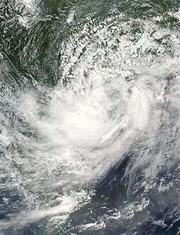 Tropical Storm Dianmu approaching Leizhou Peninsula on August 18 | |
| Formed | August 15, 2016 |
| Dissipated | August 20, 2016 |
| Highest winds |
10-minute sustained: 75 km/h (45 mph) 1-minute sustained: 75 km/h (45 mph) |
| Lowest pressure | 980 hPa (mbar); 28.94 inHg |
| Fatalities | 9 total |
| Damage | $6.9 million (2016 USD) |
| Areas affected | China, Vietnam, Laos, Myanmar, Bangladesh, India |
| Part of the 2016 Pacific typhoon season | |
Tropical Storm Dianmu was a weak tropical cyclone that struck Leizhou Peninsula, China and Northern Vietnam in mid August 2016. It was the eighth named storm of the annual typhoon season.
Meteorological history
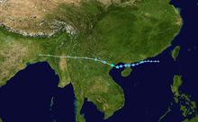
Tropical Storm Dianmu was first noted as a tropical disturbance, by the United States Joint Typhoon Warning Center (JTWC) during August 14, while it was located about 175 km (110 mi) to the south of Hong Kong, China.[1] The disturbance was located within a narrow area of low vertical windshear and had a good outflow.[1] Over the next day the system's low level circulation centre started to consolidate as it moved westwards, before it was classified as a tropical depression by the Japan Meteorological Agency (JMA) during August 15.[2][3] Over the next couple of days the system moved gradually westwards, before the JTWC issued a tropical cyclone formation alert on the system during August 17.[3][4]
The depression was named Dianmu by the JMA during August 18, after it had developed into a tropical storm, while the JTWC initiated advisories on the system and classified it as Tropical Depression 11W.[5][6] After being named, Dianmu continued to move westwards under the influence of a subtropical ridge of high pressure located to the north of the system and made landfall on China's Leizhou Peninsula.[5][6] The system subsequently entered the Gulf of Tonkin later that day, where it developed an eye feature on microwave imagery, before it peaked with sustained winds of 75 km/h (45 mph) as it made landfall on northern Vietnam during August 19.[3][6][7] Over the next day Dianmu gradually weakened as it moved westwards through Vietnam, Laos and China's Yunnan province, before it degenerated into an area of low pressure over northern Myanmar during August 20.[3][6] The remnant area of low pressure continued to be monitored, as it moved through parts of Myanmar and India, before it was last noted over Bangladesh.[8]
Preparations and impact
China
Dianmu passed about 220 km (135 mi) to the southwest of Hong Kong, China during August 17, where it generated moderate to fresh easterly winds.[6] As Dianmu moved slowly westwards, local winds over Hong Kong strengthened during that day, before the Strong Wind Signal No. 3 was issued for both territories, by the Hong Kong Observatory and the Macao Meteorological and Geophysical Bureau.[6] Strong winds were subsequently observed over Hong Kong, before all signals were cancelled during August 18.[6]
On Hainan Island, around 40 000 people were evacuated, ahead of the system affecting the island while transportation service were also affected.[6] Heavy rain associated with the system caused flooding in several places over the island, including in parts of the capital Haikou.[6] The heavy rain also brought the water level at the Longtang Dam on the Nandu River to a ten-year high of 13.35 metres (43.8 ft).
Vietnam
Within Vietnam at least 16 people were killed, while two others were missing.[6] Over in Quảng Ninh, a total of 11 houses were collapsed and total damages in the city amounted to 3.5 billion VND (US$157 thousand).[9]
See also
- Typhoon Hope (1979)
- Tropical Storm Zita (1997)
- Tropical Storm Soudelor (2009)
- Tropical Storm Bebinca (2013)
References
- 1 2 "Significant Tropical Weather Advisory for the Western and South Pacific Oceans August 14, 2016 06z". United States Joint Typhoon Warning Center. August 14, 2016. Archived from the original on August 14, 2016.
- ↑ "Significant Tropical Weather Advisory for the Western and South Pacific Oceans August 15, 2016 01z". United States Joint Typhoon Warning Center. August 15, 2016. Archived from the original on August 15, 2016.
- 1 2 3 4 Tropical Storm Dianmu (RSMC Tropical Cyclone Best Track). Japan Meteorological Agency. September 21, 2016. Archived from the original on September 21, 2016. Retrieved September 21, 2016.
- ↑ "Significant Tropical Weather Advisory for the Western and South Pacific Oceans August 17, 2016 17z". United States Joint Typhoon Warning Center. August 17, 2016. Archived from the original on August 17, 2016.
- 1 2 "JTWC Prognostic Reasoning For Tropical Depression 11W August 18, 2016 03z". United States Joint Typhoon Warning Center. Archived from the original on August 18, 2016. Retrieved August 18, 2016.
- 1 2 3 4 5 6 7 8 9 10 "Tropical Storm Dianmu August 17-20, 2016". Hong Kong Observatory. September 2, 2016. Archived from the original on June 26, 2016. Retrieved October 9, 2016.
- ↑ "JTWC Prognostic Reasoning For Tropical Depression 11W August 19, 2016 03z". United States Joint Typhoon Warning Center. Archived from the original on August 19, 2016. Retrieved August 19, 2016.
- ↑ "Tropical Storm Dianmu Running Best Track Analysis". United States Naval Research Laboratory.
- ↑ http://www.phapluatplus.vn/quang-ninh-bao-so-3-da-gay-thiet-hai-35-ty-dong-d21824.html
External links
| Wikimedia Commons has media related to Tropical Storm Dianmu (2016). |
Tropical cyclones of the 2016 Pacific typhoon season | |||||||||||||||||||||||||||||||||||||||||||||||||||||||||||||||||||||||||||||||||||||||||||||||||||||||||||||||||||||||||||||||||||||||||||||||||||||
|---|---|---|---|---|---|---|---|---|---|---|---|---|---|---|---|---|---|---|---|---|---|---|---|---|---|---|---|---|---|---|---|---|---|---|---|---|---|---|---|---|---|---|---|---|---|---|---|---|---|---|---|---|---|---|---|---|---|---|---|---|---|---|---|---|---|---|---|---|---|---|---|---|---|---|---|---|---|---|---|---|---|---|---|---|---|---|---|---|---|---|---|---|---|---|---|---|---|---|---|---|---|---|---|---|---|---|---|---|---|---|---|---|---|---|---|---|---|---|---|---|---|---|---|---|---|---|---|---|---|---|---|---|---|---|---|---|---|---|---|---|---|---|---|---|---|---|---|---|---|
 |
| ||||||||||||||||||||||||||||||||||||||||||||||||||||||||||||||||||||||||||||||||||||||||||||||||||||||||||||||||||||||||||||||||||||||||||||||||||||
| |||||||||||||||||||||||||||||||||||||||||||||||||||||||||||||||||||||||||||||||||||||||||||||||||||||||||||||||||||||||||||||||||||||||||||||||||||||