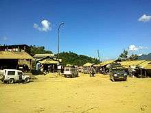
Nungba
| Nungba Lwangba | |
|---|---|
| Town | |
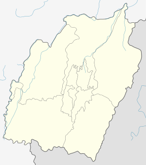 Nungba  Nungba Location in Manipur, India | |
| Coordinates: 24°45′25″N 93°25′00″E / 24.75694°N 93.41667°ECoordinates: 24°45′25″N 93°25′00″E / 24.75694°N 93.41667°E | |
| Country |
|
| State | Manipur |
| District | Tamenglong |
| Elevation | 400 m (1,300 ft) |
| • Density | 120/km2 (300/sq mi) |
| Languages | |
| • Official | Rongmei, Manipuri, English, Hindi |
| Time zone | IST (UTC+5:30) |
| PIN | 795147 |
| Telephone code | 03877 |
| Nearest city | Imphal |
| Nearest Airport | Tulihal International Airport Imphal |
| Literacy | 74% (Approx) |
| Constituency | Nungba |
| Climate | Temperate and calm (Köppen) |
| Avg. summer temperature | 30 °C (86 °F) |
| Avg. winter temperature | 02 °C (36 °F) |
| Website |
nungba |
Nungba (originally "Lwangba") is a small scenic town surrounded by a low lying hill ranges and rivers, an extension of eastern Indian Himalayas. The highest point of Nungba "Ramphaan But" which means "Viewpoint" stands high at the centre of the town. The combination of town's natural beauty and pleasant climatic conditions is an enthralling experience.
Nungba is also the administrative Headquarter of Nungba Sub-Division, Tamenglong District, Manipur State, India.
Nungba is the centre of important educational institutions namely, Nungba Govt. High School, St.John English High School, Maranatha Academy, nurturing and building the younger generation to excel. It also houses Nungba Govt. Hospital and clinics, look after and operated by well trained, dedicated and qualified Doctors and Nurses.
It is well connected by Roadways (NH 53 Passing through Nungba from Imphal to Jiri). The soon coming under- construction Indian Railway station is just an hour drive away from Nungba.
Demographics
Population
According to 2011 Census, Nungba has a population of approximately 2200 from more than 350 household.[1] The latest awaited Census report of 2015-16 is expected for more growth. Inhabitant here is Rongmei Naga Tribe. "Rongmei" is the main spoken language followed by English, Manipuri and Hindi.
Religion
The whole population of Nungba practice Christianity (Baptist, Presbyterian, Roman Catholic, Seventh Day Adventist, Assembly of Yaweh). The Church plays an important role in the society.
Administration/Office
Sub-Divisional Magistrate, Sub-Divisional Police Officer, Post Master, Chief Medical Officer functions from their respective offices headquartered in Nungba.
Geography
Nungba is nestled on the eastern end of Indian Himalayas with an area of approximately 120 Sq.Km. It lies on the India's highest Seismicity zone V. The latest seismic activity of 6.7 magnitude was recorded on early morning of 3rd January 2016, with an epicenter 50 km from Nungba.
Physiography
Hills and rivers marks as the boundary of Nungba. It is marked by a steep slope at the East and gently elongated more towards West and South.
Strategically, Nungba is closely surrounded by several other small hill towns namely- Rwangdai, Rengpang, Taodaijang, Mukti, Jiphun and Puiluan. The important rivers that flows out and surround Nungba includes river Limga, Khatha, Thingdingluangthuak and Luangphai. Other major river that marks as a natural boundaries includes Alang (Irang), Agu (Barak).
Climate
Nungba has a sub-tropical highland climate. It experience a pleasant and comfortable climatic conditions throughout the year with temperature ranging between 5-20 degree Celsius during winter and 15-30 degree Celsius during summer. The scenic town spreads along several hillocks.
Rainfall
Nungba town receives approx. 1100 millimeters annually. The rain bearing South West Monsoon brings shower from the month of April/May till August/September, a boon for agriculture.
Monsoon season is accompanied by frequent landslides along the National Highway 53 hindering flow of traffic sometime.
Flora and Fauna
There are huge varieties of Flora and Fauna. The vast forest reserves available in Nungba offers the local populace to practice a Jhum (Shifting) cultivation. Primary agricultural product includes Rice, Colocasia roots, Hot Red King Chilly, Maize, Cucumber, Ladies Finger, Mustards, Cabbage, Beans and other vegetables. Different kinds of fruits grown and produces includes Orange, Lemon, Banana, Grapes, Mango, Pine apples, Berries etc.
The huge forest covers includes Bamboos, Oaks and other large tropical trees which in turn provides a fresh water, fresh air and other forest resources. The forest woods are also used as a fuel for kitchen.
Different Animals and Birds includes Tiger (hardly spotted) Bear, Wild dogs, Wild Pigs, Deer, Monkey, Squirrel, Bulbul, Sparrow, Parrot, Crow, Eagle etc. The fresh river water is blessed with variety of fishes whose name are locally known.
Nungba is located at an elevation of 400 m from MSL.[2]
Economy
More than 70% engaged in Agricultural activities. While the remaining 30% are engaged in Govt. Sectors and other private commercial activities.
The latest discovery of Fossil Fuels in and around Nungba promises better economic condition.
Location / Connectivity
Located in Tamenglong District, Manipur India 795147. National Highway 53 passes through Nungba. It is 110 km from Imphal (Capital City of Manipur). The under-construction India Railway station is just an hour distance from Nungba.
Nearest Airport is Tulihal International Airport Imphal, 110 KM away from Nungba.