Oregon Route 281
| ||||
|---|---|---|---|---|
 | ||||
| Route information | ||||
| Maintained by ODOT | ||||
| Length: | 19.01 mi (30.59 km) | |||
| Existed: | 2002 – present | |||
| Major junctions | ||||
| South end: |
| |||
|
| ||||
| North end: |
| |||
| Highway system | ||||
| ||||

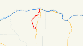
Oregon Route 281 is an Oregon state highway running from Hood River to the community of Mount Hood. OR 281 is known as the Hood River Highway No. 281 (see Oregon highways and routes). It is 19.01 miles (30.59 km) long and runs north–south, entirely within Hood River County.
OR 281 was established in 2002 as part of Oregon's project to assign route numbers to highways that previously were not assigned.
Route description
OR 281 begins at an intersection with US 30 and OR 35 at Hood River and heads south, intersecting OR 282 five miles (8 km) south of Hood River. OR 281 continues south through Winans, Dee, and Trout Creek to Parkdale. At Parkdale, OR 281 turns northeast for two miles (3 km) to the community of Mount Hood, where it ends at an intersection with OR 35.
History
OR 281 was assigned to the Hood River Highway in 2002.
Major intersections
The entire route is in Hood River County.
| Location | mi | km | Destinations | Notes | |
|---|---|---|---|---|---|
| Hood River | 0.00 | 0.00 | |||
| | 5.09 | 8.19 | |||
| Mount Hood | 19.07 | 30.69 | |||
| 1.000 mi = 1.609 km; 1.000 km = 0.621 mi | |||||
References
- Oregon Department of Transportation, Descriptions of US and Oregon Routes, http://www.oregon.gov/ODOT/HWY/TRAFFIC/TEOS_Publications/PDF/Descriptions_of_US_and_Oregon_Routes.pdf, page 29.
- Oregon Department of Transportation, Hood River Highway No. 281, ftp://ftp.odot.state.or.us/tdb/trandata/maps/slchart_pdfs_1980_to_2002/Hwy281_1999.pdf