Ocampo, Guanajuato
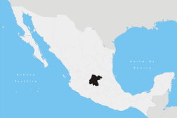
Ocampo is a city (and municipality) located in the northwest region of the Mexican state of Guanajuato. The municipality has an area of 1,019.49 square kilometres (3.7% of the surface of the state) and is bordered and to the south and east by San Felipe, to the north by the state of San Luis Potosí, to the west by the state of Jalisco. The municipality had a population of 20,984 inhabitants according to the 2005 census.[1][2]
The municipality is named after Melchor Ocampo, a 19th-century liberal statesman.
The municipal president of Ocampo and its many smaller outlying communities is Raul Castillo.[3]
Education
Fifty schools are located in Ocampo. They include:
- Escuela Primaria 18 de Marzo (La Tinajia area)[4]
External links
- Ocampo (in Spanish)
References
- ↑ "2005 Census". INEGI: Instituto Nacional de Estadística, Geografía e Informática. Retrieved 2007-03-22.
- ↑ "Mexican Municipality Encyclopedia". Enciclopedia de los Municipios de México. Archived from the original on 2007-04-22. Retrieved 2007-03-22.
- ↑ PAN, truinfa voto conservador | Revista Contralínea GUANAJUATO, periodismo de investigacion. Mayo 2006 Mexico | Agosto 2006
- ↑ Hernández, Macarena and Gary Jacobson. "Hard work translates to success at La Tinaja school in Ocampo." The Dallas Morning News. June 9, 2008.
Coordinates: 21°39′00″N 101°30′00″W / 21.650°N 101.500°W
This article is issued from Wikipedia - version of the 7/25/2016. The text is available under the Creative Commons Attribution/Share Alike but additional terms may apply for the media files.