Ocshapalca
| Ocshapalca | |
|---|---|
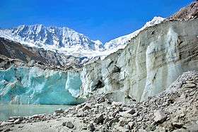 Ocshapalca (on the left) and Ranrapalca (on the right), the Llaqa Glacier and Llaqa Lake | |
| Highest point | |
| Elevation | 5,888 m (19,318 ft) |
| Coordinates | 9°24′30″S 77°26′5″W / 9.40833°S 77.43472°WCoordinates: 9°24′30″S 77°26′5″W / 9.40833°S 77.43472°W |
| Geography | |
 Ocshapalca Peru | |
| Location | Ancash, Peru |
| Parent range | Andes, Cordillera Blanca |
| Climbing | |
| First ascent | 1-1965 via N. ridge: S. face-1979: S. face (new route)-1989.[1] |
Ocshapalca[2][3] (possibly from Quechua uqsha high altitude grass,[4]pallqa bifurcation, division into two parts) is a mountain in the Cordillera Blanca in the Andes of Peru, about 5,888 m (19,318 ft) high.[2] It is situated in the Ancash Region, Huaraz Province, on the border of the districts Independencia District and Tarica. Ocshapalca lies between the mountain Hatunkunka in the west and Ranrapalca in the east.[5]
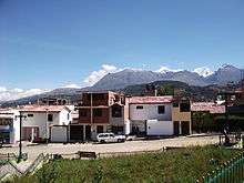
Vallunaraju, Ocshapalca and Ranrapalca (the snow-covered mountains on the right) as seen from Huaraz
References
- ↑ Neate, Jill (1994). Mountaineering in the Andes. RGS-IBG Expedition Advisory Centre, 2nd edition
- 1 2 Alpenvereinskarte 0/3b. Cordillera Blanca Süd (Peru). 1:100 000. Oesterreichischer Alpenverein. 2005. ISBN 3-937530-05-3.
- ↑ Biggar, John (2005). The Andes: A Guide for Climbers. Andes. p. 83. ISBN 9780953608720.
- ↑ Vocabulario-Comparativo-Quechua-Ecuator-Quechua-Ancash See Spanish: Paja - Ancash Quechua paha, uqsha
- ↑ escale.minedu.gob.pe - UGEL map of the Huaraz Province (Ancash Region) (unnamed)
This article is issued from Wikipedia - version of the 6/9/2016. The text is available under the Creative Commons Attribution/Share Alike but additional terms may apply for the media files.