Cordillera Blanca
| Cordillera Blanca | |
|---|---|
|
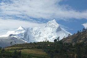
Huandoy (6,360 m) | |
| Highest point | |
| Peak | Huascarán |
| Elevation | 6,768 m (22,205 ft) |
| Coordinates | 9°07′17″S 77°36′32″W / 9.12139°S 77.60889°W |
| Dimensions | |
| Length | 180 km (110 mi) N-S |
| Width | 21 km (13 mi) |
| Geography | |
 Location of Cordillera Blanca inside Peru. | |
| Country | Peru |
| State/Province | Ancash |
| Range coordinates | 9°10′S 77°35′W / 9.17°S 77.58°WCoordinates: 9°10′S 77°35′W / 9.17°S 77.58°W |
| Parent range | Andes |
The Cordillera Blanca (Spanish for "white range") is a mountain range in Peru which is part of the larger Andes range and extends for 200 kilometres (124 mi) between 8°08' and 9°58'S and 77°00' and 77°52'W, in NW direction.[1] It includes several peaks over 6,000 metres (19,690 ft) high and 722 individual glaciers.[1] The highest mountain in Peru, Huascarán of 6,768 metres (22,205 ft), is located here.[1][2]
The Cordillera Blanca lies entirely inside the region of Ancash, and runs parallel to the Santa River valley (also called Callejón de Huaylas on its upper and midsections) on the west. Huascarán National Park, established in 1975, encompasses almost the entire range of the Cordillera Blanca.[2]
Snow melt from the Cordillera Blanca has provided part of Northern Peru with its year-round water supplies, while 5% of Peru's power comes from an hydro-electrical plant located in the Santa river valley. The area of permanent ice cover shrank by about a third between the 1970s and 2006.[3]
Geography
The Cordillera Blanca is the most extensive tropical ice-covered mountain range in the world and has the major ice concentration in Peru.[1] It is part of the Cordillera Occidental (the westernmost part of the Peruvian Andes), and trends in a northwesterly direction for 200 km between 8°08' and 9°58'S of latitude and 77°00' and 77°52' W of longitude.[1] It has five of the most spectacular peaks above 6,000 m in the Peruvian Andes; the highest peak, Huascarán, rises to an elevation of 6,768 m asl.[1] The Cordillera Blanca also acts as a continental divide: Santa River on the west drains into the Pacific Ocean whereas Marañón River on the east drains into the Atlantic Ocean.[1]
Glaciers
A total of 722 individual glaciers are recognized in this mountain range, and these cover an area of 723.4 km2.[1] Most of these glaciers are on the western side of the ranges, where 530 glaciers cover an area of 507.5 km2; while on the eastern side 192 glaciers cover an area of 215.9 km2.[1] Most of the glaciers, 91 percent of the total, are classified as mountain glaciers (they are generally short and have extremely steep slopes); the rest are classified as valley glaciers, except for one ice cap.[1]
As with all Andean glaciers, the Cordillera Blanca has witnessed a major retreat of its during the 20th century due to global climate change. Studies have shown a retreat of over 15% since the 1970s.[4]
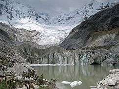
Lakes
Among the most important lakes in the range are: the Llanganuco Lakes[5] which are located at the northern side of Huascarán, and accessible from the town of Yungay;[2] Lake Parón (the biggest lake in the Cordillera Blanca), located just north of Huandoy, accessible from the town of Caraz, its waters have a deep turquoise hue;[2][6][7] the lakes Ichiccocha and Jatuncocha,[7] which lie in the vicinity of Artesonraju and Alpamayo and are accessible only by trekking or on horseback from Caraz.
Other notable lakes are Laguna 69, Lake Allicocha,[8] Lake Auquiscocha,[9] Lake Palcacocha, Lake Querococha and Lake Conococha.[7]
Peaks
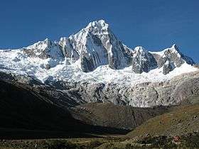
There are several 6,000 m peaks in the Cordillera Blanca with a 400 m topographic prominence, and several other peaks over 5,500 m.[10] Huascarán Sur, the highest peak, has two commonly quoted heights - 6,746 m from the Peruvian National Geographic Institute (IGN) map, and 6,768 m from the Austrian Alpine Club (OeAV) survey map.[11]
A selection of some of the highest peaks of the Cordillera Blanca is listed below.[12]


|
|
|
Hot springs
Among the most important in the area are: Monterrey and Chancos, which are transformed in thermal bath facilities. Both are at 7 and 27 km respectively from the regional capital, Huaraz.[13][14]
| Musho | ||||||||||||||||||||||||||||||||||||||||||||||||||||||||||||
|---|---|---|---|---|---|---|---|---|---|---|---|---|---|---|---|---|---|---|---|---|---|---|---|---|---|---|---|---|---|---|---|---|---|---|---|---|---|---|---|---|---|---|---|---|---|---|---|---|---|---|---|---|---|---|---|---|---|---|---|---|
| Climate chart (explanation) | ||||||||||||||||||||||||||||||||||||||||||||||||||||||||||||
| ||||||||||||||||||||||||||||||||||||||||||||||||||||||||||||
| ||||||||||||||||||||||||||||||||||||||||||||||||||||||||||||
Climate
Dry season extends from May to September, being June and July the months with less rain and more stable weather.[15] The data on the chart correspond to the village of Musho (3084 m.),[16] located at the foot of Huascarán.[17]
Ecology
Flora and fauna are adapted to climate and elevational range of mountainous areas. Almost all the extension of the Cordillera Blanca is protected by Huascarán National Park.[2]
Flora
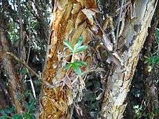
The main types of plant communities present in the area are: the vegetation of inter-Andean valleys (xerophytic plants in the lower elevations and shrubs and grassland at the higher elevations) and high altitude vegetation (Puna grasslands and patches of high Andean forest).[18]
Plants have adapted to the intense solar radiation, low temperatures and water availability. Most plant species have pubescent leaves, an adaptation which protects the plants from water loss for the intense solar radiation and from the low night temperatures of the mountain climate.[19]
Examples of typical vegetation of this area are: Polylepis racemosa, Escallonia resinosa, Alnus acuminata, Senna birostris, Vallea stipularis, Lupinus spp., Vaccinium floribundum, Puya raimondii, Calamagrostis vicunarum, Festuca dolichophylla, Jarava ichu, Azorella spp., Ranunculus macropetalus, etc.[19]
Fauna
More than 120 bird species have been reported from Huascarán National Park,[2] being the most notorious: the Andean condor, the torrent duck, the puna tinamou, the brown pintail, the Andean crested duck, the white-tufted grebe, the giant coot and the Andean gull.[2]
Among the mammals reported from the same area are: the colocolo, the Andean mountain cat, the spectacled bear, the taruca deer, the vicuña, the white-tailed deer, the puma, the northern viscacha, the long-tailed weasel, the hog-nosed skunk and the Andean fox.[2]
See also
- Cordillera Blanca Fault Zone
- List of mountains in Peru
- Cordillera Negra
- Huascarán National Park
- Cordillera Central (disambiguation)
- Ancash Region
References
- 1 2 3 4 5 6 7 8 9 10 "Peruvian Cordilleras". USGS. Retrieved August 16, 2014.
- 1 2 3 4 5 6 7 8 "Huascarán - Servicio Nacional de Áreas Naturales Protegidas por el Estado". www.sernanp.gob.pe (in Spanish). Retrieved 2016-05-29.
- ↑ Painter, James (2007-03-12). "Peru's alarming water truth". BBC News Online: Americas. News.BBC.co.uk. Archived from the original on 2007-03-14.
- ↑ Lynas, Mark: High tide: the truth about our climate crisis, pg. 230, ISBN 978-0-312-30365-5
- ↑ "Laguna de Llanganuco". Inventario Turistico del Peru (in Spanish). MINCETUR. Retrieved 24 January 2016.
- ↑ "Laguna Parón". Inventario Turistico del Peru (in Spanish). MINCETUR. Retrieved 5 November 2016.
- 1 2 3 Portocarrero, César; Engility Corp. (2014). The Glacial Lake Handbook (PDF). USAID.
- ↑ "Laguna Allicocha". MINCETUR. Retrieved July 4, 2016.
- ↑ "Laguna Auquiscocha". Inventario Turistico del Peru (in Spanish). MINCETUR. Retrieved 5 November 2016.
- ↑ Biggar, John; et al. "Andes Peak Lists". Andes.
- ↑ Jonathan de Ferranti; et al. "South American Prominence Lists". Peaklist.org.
- ↑ Taken from Mountaineering in the Andes by Jill Neate, RGS-IBG Expedition Advisory Centre, 2nd edition, May 1994
- ↑ "Baños Termales de Monterrey". Inventario Turístico del Perú (in Spanish). MINCETUR. Retrieved 2016-06-01.
- ↑ "Baños Termales de Chancos". Inventario Turístico del Perú (in Spanish). MINCETUR. Retrieved 2016-06-01.
- ↑ Biggar, John (2005). "Northern Peru". The Andes: A Guide for Climbers. Andes. ISBN 978-0-9536087-2-0.
- ↑ "Clima: Musho - Climograma, Diagrama de temperatura, Tabla climática - Climate-Data.org". es.climate-data.org. Retrieved 2016-07-17.
- ↑ Peru 1:100 000, Carhuás (19-h). IGN (Instituto Geográfico Nacional - Perú).
- ↑ Villanueva, Ricardo (2011). Características de la Cuenca del Río Santa (PDF) (in Spanish). UICN SUR.
- 1 2 Smith, David N. (1988). Flora and vegetation of the Huascarán National Park, Ancash, Peru: with preliminary taxonomic studies for a manual of the flora (Ph.D. Thesis). Iowa State University.
| Wikimedia Commons has media related to Cordillera Blanca. |
External links
- Summitpost page on Cordillera Blanca
- Google Maps view of Cordillera Blanca
- Peak Lists for the Andes, including Peruvian Peaks