Odolanów
| Odolanów | |||
|---|---|---|---|
|
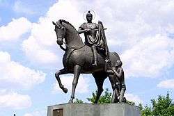
Statue of Saint Martin | |||
| |||
 Odolanów | |||
| Coordinates: 51°34′N 17°40′E / 51.567°N 17.667°E | |||
| Country |
| ||
| Voivodeship | Greater Poland | ||
| County | Ostrów Wielkopolski | ||
| Gmina | Odolanów | ||
| Area | |||
| • Total | 4.76 km2 (1.84 sq mi) | ||
| Population (2006) | |||
| • Total | 4,960 | ||
| • Density | 1,000/km2 (2,700/sq mi) | ||
| Postal code | 63-430 | ||
| Climate | Cfb | ||
| Website | http://www.odolanow.pl | ||

Odolanów [ɔdɔˈlanuf] (German: Adelnau) is a town in the Greater Poland Voivodeship of Poland, about 10 kilometres (6 miles) south-west from Ostrów Wielkopolski, with over 5000 inhabitants.
History
The first written document that mentionins Odolanów dates back to 1301 during the Piast dynasty, when the location hosted a castle on the border between Greater Poland (Wielkopolska) and Silesia (Śląsk). A settlement arose next to the castle, which acquired city rights in 1400 from King Władysław II Jagiełło.
Until 1793, the town and surrounding villages belonged to princes, kings, or noblemen. Monarchs granted the land to various rich feudals as fief or land tenancy. During this time, Odolanów was constantly under the administrative influence of Kalisz.
In 1793 Odolanów became Prussian as a result of the partitioning of Poland, and shortly within the Duchy of Warsaw.
After World War I the town became part of the Second Polish Republic. The local populace had to acquire Polish citizenship or leave the country.
People
- Rafał Leszczyński (1650-1703)
- Wilhelm Altmann (1862-1951)
References
External links
- Odolanów On-Line (in Polish)
See also
Coordinates: 51°34′N 17°42′E / 51.567°N 17.700°E
| Town and seat |  | |
|---|---|---|
| Villages | ||