Ogdensburg–Prescott International Bridge
| Ogdensburg–Prescott International Bridge | |
|---|---|
 | |
| Carries |
|
| Crosses | Saint Lawrence River/Saint Lawrence Seaway |
| Owner | Ogdensburg Bridge and Port Authority |
| Website | http://www.ogdensport.com/ |
| Preceded by | Thousand Islands Bridge |
| Followed by | Three Nations Crossing |
| Characteristics | |
| Design | Suspension bridge |
| Total length | 1.5 miles |
| Longest span | 350.75 metres/1,150.8 ft |
| Number of spans | 6 deck and 1 Main w/ US & Canadian approaches. |
| History | |
| Construction end | 1960 |
| Statistics | |
| Toll | $2.75[1] |

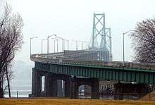
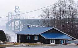
The Ogdensburg–Prescott International Bridge, also known as the St. Lawrence Bridge and the Seaway Skyway, is a suspension bridge connecting Ogdensburg, New York in the United States to Johnstown, Ontario (a few kilometres east of Prescott) in Canada. Designed by Modjeski & Masters and completed in 1960, it has 6 spans and a main span of 350.75 metres (1,150.8 ft) totaling 2.4 kilometres (1.5 mi) across the Saint Lawrence River and Saint Lawrence Seaway.[2]
Accessibility
The Ogdensburg-Prescott International Bridge allows for both passenger and commercial vehicles to cross the Canada-United States border; neither cyclists or pedestrians are permitted to cross this bridge. The bridge is a very popular border crossing for passenger vehicles due to its proximity to Ottawa on the Canadian side, with 410,000 vehicles crossing in 2011 alone. The bridge was designed for heavy loads and has a weight capacity of 105,000 pounds.[3] The weight limit easily accommodates semi-trailer trucks. This bridge, however, does not see as much commercial traffic as the nearby Thousand Islands Bridge, as it is not a direct route to any American interstate highway.[4]
On the Canadian side, the bridge connects to Highway 16, a highway which interchanges with Highway 401 and Highway 416 that continues north to Ottawa.
On the American side, the bridge connects to New York State Route 812, which connects with New York State Route 37 a few blocks from the southern end. Route 812 joins Route 37 west into Ogdensburg. It then goes south to Village of Lowville in Lewis County. Route 37 continues west to a fork at Morristown, N.Y. where Route 12 picks up to Alexandria Bay and Interstate 81.
History
Notable events
On 1 September 2015, the Ogdensburg-Prescott International Bridge made headlines after Prime Minister Stephen Harper posted a video to his Facebook page standing in front of the bridge and the Port of Johnstown.[5] The video was supposed to be a congratulatory video about the shipbuilding industry in the Halifax harbour in Halifax, Nova Scotia, however upon its release, locals of Halifax noticed inconsistencies with the scenery compared to that of the Halifax harbour and began to question where the video was actually shot. By 5 September, viewers had determined the video was actually shot in Johnstown, Ontario based on the quick shot of the port in the background, which was unmistakably the Port of Johnstown. Viewers then accused Harper of trying to pass off the scenery as the Halifax harbour due to the undeniable similarities between the Ogdensburg-Prescott bridge and the A. Murray MacKay Bridge in the Halifax harbour.[6]
See also
- List of crossings of the Saint Lawrence River
- Toronto Island Ferry - which acquired two car ferries, Maple City (1951) and Windmill Point (1954), that served Ogdensburg and Prescott from the 1950s to 1960.
Other suspension bridges in Ontario:
- Sewells Road Suspension Bridge
- Ambassador Bridge
- Thousand Islands Bridge
- Buffalo and Fort Erie Public Bridge Authority
- Niagara Falls Bridge Commission
References
- ↑ "Customs Border Crossings". United Counties of Leeds and Grenville. Retrieved 1 July 2015.
- ↑ "Ogdensburg Prescott International Bridge". Nicolas Janberg's Structurae. Retrieved 2009-08-05.
- ↑ "Home". Ogdensport.com. Retrieved 2016-02-27.
- ↑ "Ogdensburg-Prescott International Bridge –". Ezbordercrossing.com. 2014-06-20. Retrieved 2016-02-27.
- ↑ "Bridge stand-in: Harper celebrates Halifax shipbuilding in Ontario | The Chronicle Herald". Thechronicleherald.ca. 2015-09-03. Retrieved 2016-02-27.
- ↑ "Harper video about Halifax, but shot in Ontario, prompts confusion - Politics - CBC News". Cbc.ca. 2015-09-04. Retrieved 2016-02-27.
External links
| Wikimedia Commons has media related to Ogdensburg–Prescott International Bridge. |
- The Ogdensburg Bridge and Port Authority
- Entry at bridgemeister.com
- Ogdensburg Prescott International Bridge at Structurae
Coordinates: 44°44′07″N 75°27′34″W / 44.735316°N 75.459487°W
| Bridges of the St. Lawrence River | ||||
|---|---|---|---|---|
| ||||