Ohio River flood of 1937

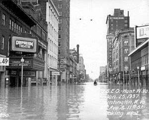
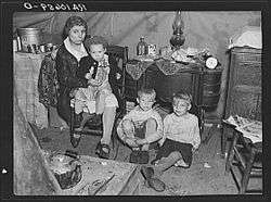
The Ohio River flood of 1937 took place in late January and February 1937. With damage stretching from Pittsburgh to Cairo, Illinois, one million people were left homeless, with 385 dead and property losses reaching $500 million ($8.7 billion in 2015 dollars). Federal and state resources were strained to aid recovery, as the disaster occurred during the depths of the Great Depression and a few years after the Dust Bowl.[1]
Event timeline
- January 5: Water levels began to rise.
- January 10–18: Numerous flood warnings were issued across much of the region.
- January 13–24: Near record rainfalls were recorded.
- January 18: Numerous homes were flooded as the Ohio River started to overflow its banks due to the heavy rains.
- January 23–24: Martial law was declared in Evansville, Indiana, where the water level was at 54 feet (16 m).[2]
- January 26: River gauge levels reached 80 feet (24 m) in Cincinnati, the highest level in the city's history.[3]
- January 27: River gauge reached 57 feet (17 m) in the Louisville area, setting a new record. Seventy percent of the city was under water at that time.[4]
- February 2: River gauge reached over 60 feet (18 m) in Paducah, Kentucky.[4]
- February 5: Water levels fell below the flood stage for the first time in nearly three weeks in several regions.
Aftermath and reconstruction

Media response
A handful of powerhouse radio stations, including WLW and WHAS, quickly switched to non-stop news coverage, transmitting commercial-free for weeks. These broadcasts consisted mostly of messages being relayed to rescue crews, as many civil agencies had no other means of communication. The Regionalist painter Thomas Hart Benton was commissioned by The Kansas City Star and St. Louis Post-Dispatch newspapers to provide sketches depicting the miserable conditions of the flooded areas in the Missouri Bootheel region.[5]
When it became obvious that the river would cut the electric power to radio station WHAS—thus cutting the last radio voice in Cincinnati and Louisville—the rival clear channel station in Nashville, WSM, picked up WHAS's broadcast via telephone and broadcast emergency flood reports for three days for the lower Ohio River. Other stations across the country did much the same.
Government response
In January 1937, the U.S. Army Corps of Engineers, District Engineer, MAJ Bernard Smith dispatched an entire fleet down the Cumberland River for rescue and relief work in response to the severe flooding. The bridges were too low to allow the vessels to pass under, so the vessels were forced to steam across farmland and bridge approaches, dodging telephone and power lines.[6]
The federal government under President Franklin D. Roosevelt sent thousands of area WPA workers to the affected cities to aid in rescue and recovery. It also sent supplies for food and temporary housing, and millions of dollars in aid after the floodwaters receded.
The scale of the 1937 flood was so unprecedented that civic and industrial groups lobbied national authorities to create a comprehensive plan for flood control. The plan involved creating more than seventy storage reservoirs to reduce Ohio River flood heights. Not fully completed by the Army Corps of Engineers until the early 1940s, the new facilities have drastically reduced flood damages since.
In the 1930s, the Tennessee Valley Authority sought to create a continuous minimum 9-foot (2.7 m) channel along the entirety of the Tennessee River from Paducah to Knoxville. The Authority also sought to help control flooding on the lower Mississippi River, especially in the aftermath of the Ohio River flood of 1937, as research had shown that 4% of the water in the lower Mississippi River originates in the Tennessee River watershed. TVA surveyed the lower part of the river and considered the Aurora Landing site, but eventually settled on the present site at river mile 22.4. The Kentucky Dam project was authorized on May 23, 1938, and construction began July 1, 1938.[7]
Much of the work of the Tennessee Valley Authority in the Tennessee River basin was strongly supported by the majority of the citizens in western Kentucky and their representatives in the United States Congress. U.S. Sen. Alben W. Barkley of Paducah and U.S. Rep. William Gregory from Mayfield and his brother U.S. Rep. Noble Gregory from Mayfield who succeeded him in office strongly supported the funding of TVA and its role in addressing flood control, soil conservation, family relocation, recreation, production of electricity, and economic development.[8]
States seriously affected
Ohio
Six to 12 inches (300 mm) of rain fell in Ohio during January 13–25, 1937, totals never before or since equaled over such a large area of Ohio. January 1937 remains as the wettest month ever recorded in Cincinnati.[9]
One hundred thousand people in Cincinnati were left homeless, as the flood affected the city from January 18 to February 5. The river reached its peak on January 26, at 79.9 feet (24.4 m), more than 25 feet (7.6 m) higher than flood stage.[10] Ohio River levels on January 26–27 were the highest known from Gallipolis downstream past Cincinnati. Crests were 20 to 28 feet (8.5 m) above flood stage and 4 to 9 feet (2.7 m) above the previous record of 1884. 12 square miles (31 km2) of the city's area was flooded,[11] the water supply was cut, and streetcar service was curtailed.
At Portsmouth, the rising river threatened to top the flood wall, erected 10 feet (3.0 m) above flood stage. City officials deliberately opened the flood gates and allowed river water to flood the business district 8 to 10 feet (3.0 m) deep, thus preventing a catastrophic breaching of the flood wall. The Ohio River eventually crested 14 feet (4.3 m) over the top of the flood wall. Among the flooded structures was Crosley Field, home field of the Cincinnati Reds baseball team. Additionally, the amusement park Coney Island was submerged, causing pieces of carousel horses to float away, which were recovered as far downriver as Paducah.[12] Ten people died, many fewer than the 467 killed in the floods of March 1913.
Indiana

The river rose to a record 53.74 feet (16.38 m), which was 19 feet (5.8 m) above flood stage, and sent water over the six-month-old riverfront plaza in Evansville. The city and state declared martial law on January 24 and the federal government sent 4,000 WPA workers to the city to assist rescue operations.[13] Residents were rapidly evacuated from river towns by train and bus in the early stages of the flood, making Indiana the only state to avoid drowning fatalities. More than 100,000 persons were left homeless by the disaster.
The WPA workers led the cleanup of the city. The Evansville Merchants Retail Bureau took out newspaper ads to praise their work:[2]
Before and during the flood these men of WPA were active in salvaging property and saving lives, and immediately afterward they handled the cleanup job with such efficiency that many visitors were amazed that there was practically no evidence of the flood left throughout our entire city. All honor and gratitude is due to the rank and file of the WPA for their often almost super-human efforts, always giving their best in the interest of humanity.
The Red Cross and federal government spent the equivalent of $11 million in today's money in aid to the city. The Indiana State Flood Commission was created in response, and it established the Evansville-Vanderburgh Levee Authority District, which built a system of earth levees, concrete walls, and pumping stations to protect the city.[13]
Jeffersonville welcomed the 1,000 WPA workers who came to rescue that city's residents. The federal government spent $500,000 in aid there, and $70,000 in New Albany.[2] The Pennsylvania Railroad evacuated many area residents by train from its depot in Jeffersonville. Several small riverside towns, such as Mauckport and New Amsterdam, were so devastated that they never recovered.
Illinois
Harrisburg suffered flooding from the Ohio River in 1883–1884 and again in 1913. Its most severe flood was in 1937, when much of the city, except "Crusoe's Island", was underwater. Floodwaters reached nearly 30 miles (48 km) inland and Harrisburg was nearly destroyed. Afterwards, the Army Corps of Engineers erected a levee north and east of the city to protect it from future floods. The levee has become the official northern and eastern border of the town.
The historic city of Shawneetown was completely inundated and the residents were forced to move to a tent city on the outskirts. Property damages in the southern Illinois region amounted to more than $75 million ($1.2 billion in 2015). Over three hundred bridges were smashed, six schools were ruined, and twelve hundred submerged homes. Flood waters were recorded at 65.4 feet. Damage in Old Shawneetown was so cataclysmic the town relocated three miles inland to higher ground away from the river.
Kentucky

Several businesses in the Louisville area were devastated, especially the famed Rose Island amusement park (on the Indiana side of the river near Charlestown), which never rebuilt. As a result of the flood, newer development in Louisville was directed to the east out of the flood plain. The east side has benefited by a long-term concentration of wealth among residents and businesses which located away from the older central and western areas of the city.
At Paducah, the Ohio River rose above its 50-foot (15 m) flood stage on January 21, cresting at 60.8 feet (18.5 m) on February 2 and receding again to 50 feet (15 m) on February 15. For nearly three weeks, 27,000 residents were forced to flee to stay with friends and relatives in higher ground in McCracken County or in other counties. Some shelters were provided by the American Red Cross and local churches. Buildings in downtown Paducah bear historic plaques that note the high-water marks, and at least one historic marker indicates the farthest inland extent of flood waters in the city.
With 18 inches (460 mm) of rainfall in 16 days, along with sheets of swiftly moving ice, the '37 flood was the worst natural disaster in Paducah's history. Because Paducah's earthen levee was ineffective against this flood, the United States Army Corps of Engineers was commissioned to build the flood wall that now protects the city.
References
- ↑ "Infamous Floods – Flood of 1997", The Enquirer
- 1 2 3 "Ohio River Flood, 1937", The Lilly Libraries, Indiana University, Bloomington
- ↑ "Flood of 1937 – Flood of 1997", The Enquirer
- 1 2 "Fact Sheet: Ohio River Floods". Western Kentucky University. Archived from the original on June 4, 2008. Retrieved August 10, 2015.
- ↑ "Bonhams : Thomas Hart Benton (1889-1975) Study for "Spring on the Missouri" 9 x 12in". bonhams.com. Retrieved August 10, 2015.
- ↑ "Dates In History". Lrn.usace.army.mil. Retrieved August 13, 2012.
- ↑ Tennessee Valley Authority, The Kentucky Project: A Comprehensive Report on the Planning, Design, Construction, and Initial Operations of the Kentucky Project, Technical Report No. 13 (Washington, D.C.: U.S. Government Printing Office, 1951), pp. 1–12, 68, 115–116, 509.
- ↑ Kleber, John E., ed (1992). "Tennessee Valley Authority", p.875. The Kentucky Encyclopedia. Associate editors: Thomas D. Clark, Lowell H. Harrison, and James C. Klotter. Lexington, Kentucky: The University Press of Kentucky. ISBN 0813117720.
- ↑ Horstmeyer, Steve (Dec 1995). "It's Not the Heat, It's The...". Cincinnati Magazine. p. 66. Retrieved May 18, 2013.
- ↑ Felix Winternitz & Sacha DeVroomen Bellman (2007). Insiders' Guide to Cincinnati. Globe Pequot. p. 35. Retrieved May 8, 2013.
- ↑ Federal Writers' Project (1943). Cincinnati, a Guide to the Queen City and Its Neighbors. p. 154. Retrieved May 4, 2013.
- ↑ "Coney Island Cincinnati – History". Coneyislandpark.com. Retrieved August 13, 2012.
- 1 2 Rich Davis (January 7, 2007). "When disaster strikes". Evansville Courier & Press. Retrieved January 7, 2007.
Further reading
- Bell, Rick (2007). The Great Flood of 1937: Rising Waters, Soaring Spirits. Louisville, Kentucky: Butler Books. ISBN 1-884532-82-9. Retrieved August 9, 2015.
- Breaux, Gustave A. (April 1937). "1937 Flood at Louisville". Filson Club History Quarterly. 11 (2).
- Welky, David. The Thousand-Year Flood: The Ohio-Mississippi Disaster of 1937 (University of Chicago Press; 2011) ISBN 9780226887166 Read the introduction to the book.
External links
| Wikimedia Commons has media related to 1937 Ohio River flood. |
- "Pictures of Cincinnati during the 1937 flood", The Enquirer
- Images of the Public Library of Cincinnati wiki
- 1937 Flood images from University of Louisville Libraries' Digital Collections
- A personal account of the 1937 flood, Woodspoint
- "Portsmouth, Ohio", The Ackerman Collection of Historic Photographs, Southern Ohio Museum
- 1937 "Flood pictures of Posey County", Mt. Vernon, Indiana, Website
- Man Against the River YouTube video (9.55 min.). Describes the work of the Works Projects Administration in helping victims of 1937 flood of the Ohio River.