Ohio State Route 132
| ||||
|---|---|---|---|---|
 | ||||
| Route information | ||||
| Maintained by ODOT | ||||
| Length: | 40.05 mi[1] (64.45 km) | |||
| Existed: | 1923 – present | |||
| Major junctions | ||||
| South end: |
| |||
| ||||
| North end: |
| |||
| Location | ||||
| Counties: | Clermont, Warren, Clinton | |||
| Highway system | ||||
| ||||

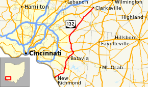
State Route 132 (SR 132) is a north–south state highway in the southwestern portion of the U.S. state of Ohio. Its southern terminus is at its interchange with U.S. Route 52 in New Richmond and its northern terminus is at its intersection with SR 350 and SR 133 in Clarksville.
History
SR 132 was commissioned in 1923 on the same route as it currently follows, between New Richmond and Owensville.[2][3] The highway between New Richmond and Batavia was paved in 1927.[4][5] In 1937 the route was extended north to Clarksville.[6][7] The section of road between SR 131 and Clarksville was paved in 1942.[8][9] The final section to be paved was between Owensville and SR 131, and it was paved in 1946.[10][11]
Major intersections
| County | Location | mi[1] | km | Destinations | Notes |
|---|---|---|---|---|---|
| Clermont | New Richmond | 0.00 | 0.00 | Southern terminus of SR 132 | |
| Ohio Township | 4.97 | 8.00 | Eastern terminus of SR 749 | ||
| Pierce–Batavia township line | 6.99 | 11.25 | Western end of SR 125 concurrency | ||
| 7.31 | 11.76 | Eastern end of SR 125 concurrency | |||
| Batavia | 11.80 | 18.99 | Southern end of SR 222 concurrency | ||
| 12.43 | 20.00 | Eastbound entrance and exit | |||
| Batavia Township | 12.52 | 20.15 | Northern end of SR 222 concurrency | ||
| 12.73 | 20.49 | Westbound entrance and exit | |||
| Stonelick Township | 15.83 | 25.48 | Southern end of SR 276 concurrency | ||
| Owensville | 16.19 | 26.06 | Northern terminus of SR 276; eastern end of US 50 concurrency | ||
| 16.55 | 26.63 | Western end of US 50 concurrency | |||
| Stonelick Township | 20.58 | 33.12 | |||
| Goshen Township | 23.50 | 37.82 | Southern terminus of SR 48 | ||
| 24.80 | 39.91 | Western end of SR 28 concurrency | |||
| 26.20 | 42.16 | Eastern end of SR 28 concurrency | |||
| Warren | Harlan Township | 32.94 | 53.01 | ||
| 38.73 | 62.33 | Southern end of SR 133 concurrency | |||
| Clinton | Clarksville | 41.05 | 66.06 | Northern end of SR 133 concurrency; northern terminus of SR 132 and SR 133 | |
1.000 mi = 1.609 km; 1.000 km = 0.621 mi
| |||||
References
- 1 2 Ohio Department of Transportation. "Technical Services Straight Line Diagrams". Retrieved April 30, 2010.
- ↑ Ohio Department of Highways and Public Works (April 1922). Map of Ohio State Highways (MrSID) (Map). Columbus: Ohio Department of Highways and Public Works. Retrieved October 12, 2013.
- ↑ Ohio Department of Highways and Public Works (July 1923). Map of Ohio Showing State Routes (MrSID) (Map). 1:760,320. Columbus: Ohio Department of Highways and Public Works. Retrieved October 12, 2013.
- ↑ Ohio Department of Highways and Public Works (August 1, 1926). Map of Ohio Showing State Routes (MrSID) (Map). 1:760,320. Columbus: Ohio Department of Highways and Public Works. OCLC 5673562. Retrieved October 12, 2013.
- ↑ Ohio Department of Highways and Public Works (June 1, 1927). Map of Ohio Showing State Routes (MrSID) (Map). 1:760,320. Columbus: Ohio Department of Highways and Public Works. OCLC 5673562. Retrieved October 12, 2013.
- ↑ Ohio Department of Highways (1936). Official Highway Map of Ohio (MrSID) (Map). 1:760,320. Columbus: Ohio Department of Highways. OCLC 5673562. Retrieved October 12, 2013.
- ↑ Ohio Department of Highways (1937). Official Highway Map of Ohio (MrSID) (Map). 1:633,600. Columbus: Ohio Department of Highways. OCLC 5673562, 16960304. Retrieved October 12, 2013.
- ↑ Ohio Department of Highways (1941). Official Highway Map of Ohio (MrSID) (Map). 1:633,600. Columbus: Ohio Department of Highways. OCLC 5673562, 7408262. Retrieved October 12, 2013.
- ↑ Ohio Department of Highways (1942). Official Highway Map of Ohio (MrSID) (Map). 1:633,600. Columbus: Ohio Department of Highways. OCLC 5673562, 54667349. Retrieved October 12, 2013.
- ↑ Ohio Department of Highways (1945). Official Highway Map of Ohio (MrSID) (Map). 1:633,600. Columbus: Ohio Department of Highways. OCLC 5673562. Retrieved October 12, 2013.
- ↑ Ohio Department of Highways (1946). Official Highway Map of Ohio (MrSID) (Map). 1:633,600. Columbus: Ohio Department of Highways. OCLC 5673562, 13655772. Retrieved October 12, 2013.
This article is issued from Wikipedia - version of the 5/21/2016. The text is available under the Creative Commons Attribution/Share Alike but additional terms may apply for the media files.