Ohio State Route 222
| ||||
|---|---|---|---|---|
 | ||||
| Route information | ||||
| Maintained by ODOT | ||||
| Length: | 29.14 mi[1] (46.90 km) | |||
| Existed: | 1923[2][3] – present | |||
| Major junctions | ||||
| South end: |
| |||
| North end: |
| |||
| Location | ||||
| Counties: | Clermont | |||
| Highway system | ||||
| ||||

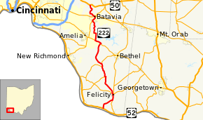
State Route 222 (SR 222) is a 29.14-mile-long (46.90 km) north–south state highway in the southwestern part of the U.S. state of Ohio. The southern terminus of SR 222 is at U.S. Route 52 (US 52) in the village of Chilo. Its northern terminus is at a signalized T-intersection with US 50 approximately 3.50 miles (5.63 km) northwest of Batavia.
Route description
The entirety of SR 222 is situated within Clermont County. No section of this state route is included within the National Highway System (NHS), a network of highways that are deemed most important for the economy, mobility and defense of the nation.[4]
History
The designation of SR 222 took place in 1923. Originally, the highway was routed from its present southern terminus in Chilo to its junction with the former SR 25 in Monroe Township.[2][3] SR 222 was extended to the north in 1937, traveling from SR 125 in Batavia Township to its current northern terminus at US 50.[5][6]
Major intersections
The entire route is in Clermont County.
| Location | mi[1] | km | Destinations | Notes | |
|---|---|---|---|---|---|
| Chilo | 0.00 | 0.00 | Southern terminus | ||
| Franklin Township | 3.36 | 5.41 | Southern end of SR 133 concurrency | ||
| Felicity | 4.71 | 7.58 | Northern end of SR 133 concurrency; southern end of SR 756 concurrency | ||
| 4.99 | 8.03 | Northern end of SR 756 concurrency | |||
| Washington Township | 9.52 | 15.32 | Eastern terminus of SR 743 | ||
| Tate Township | 11.83 | 19.04 | Southern end of SR 232 concurrency | ||
| 12.56 | 20.21 | Northern end of SR 232 concurrency | |||
| Batavia Township | 17.95 | 28.89 | Southern end of SR 125 concurrency | ||
| 19.41 | 31.24 | Northern end of SR 125 concurrency | |||
| Batavia | 25.00 | 40.23 | Southern end of SR 132 concurrency | ||
| 25.67 | 41.31 | Interchage; northern end of SR 132 concurrency | |||
| Stonelick Township | 29.14 | 46.90 | |||
1.000 mi = 1.609 km; 1.000 km = 0.621 mi
| |||||
References
- 1 2 Ohio Department of Transportation. "Technical Services Straight Line Diagrams: SR 222, Clermont County" (PDF). Retrieved 2011-05-01.
- 1 2 Map of Ohio State Highways (MrSID) (Map). Cartography by ODHPW. Ohio Department of Highways and Public Works. April 1922. Retrieved 2011-05-07.
- 1 2 Map of Ohio Showing State Routes (MrSID) (Map). Cartography by ODHPW. Ohio Department of Highways and Public Works. July 1923. Retrieved 2011-05-07.
- ↑ National Highway System: Ohio (PDF) (Map). Federal Highway Administration. December 2003. Retrieved 2011-05-07.
- ↑ Official Ohio Highway Map (MrSID) (Map). Cartography by ODOH. Ohio Department of Highways. 1936. Retrieved 2011-05-07.
- ↑ Official Ohio Highway Map (MrSID) (Map). Cartography by ODOH. Ohio Department of Highways. 1937. Retrieved 2011-05-07.