Ohio State Route 142
| ||||
|---|---|---|---|---|
 | ||||
| Route information | ||||
| Maintained by ODOT | ||||
| Length: | 13.657 mi[1] (21.979 km) | |||
| Existed: | 1926 – present | |||
| Major junctions | ||||
| West end: |
| |||
| East end: |
| |||
| Location | ||||
| Counties: | Madison | |||
| Highway system | ||||
| ||||

State Route 142 (SR 142) is a state highway in Madison County, Ohio, west of the state capital Columbus. It begins in downtown London and acts as a spur of U.S. Route 42 serving West Jefferson, before ending at an interchange with Interstate 70 north of West Jefferson. The interchange provides Interstate access to West Jefferson, nearby Lake Darby, and Plain City via Madison County Route 7.[2]
Route description

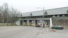
The route begins at the intersection of Main and High streets in downtown London. Main Street carries SR 56 both southeast and northwest of here, SR 38 and SR 665 to the southeast. High Street carries US 42 southwest and northeast of this point and SR 38 northeast of there. US 42, SR 38, and SR 142 form a concurrency and head northeast along High Street for three blocks. At Elm Street, US 42 and SR 38 break off from High Street leaving SR 142 along to continue northeast along High Street. The route passes through residential neighborhoods at first but near the eastern outskirts of the city, SR 142 passes several large distribution warehouses. For the five miles (8.0 km) between London and West Jefferson, the route passes many farms and some houses. As the route enters the village limits of West Jefferson, SR 142 and a Norfolk Southern railroad line head northeast into the village and gradually come closer together. Residences and local roads line the north side of the route. At US 40, officially Main Street but also a part of the National Road, SR 142 and US 40 intersect at a skewed angle. Both routes head under the aforementioned rail line and into the central business district of the village. The two routes exit the central portion of the village and enter Jefferson Township. At Plain City-Georgesville Road (CR 7), SR 142 turns north and heads into an outer reach of West Jefferson. The north-south portion of the route is surrounded mostly by farmland but a satellite office of the Battelle Memorial Institute is located along this portion of SR 142. The route ends at I-70's exit 85, a diamond interchange. CR 7 continues north towards Plain City.[3]
History
SR 142 was created in 1927 as a renumbering of SR 28 which ran from Cincinnati to West Jefferson. That year, US 42 replaced most of SR 28 but the segment from London to West Jefferson became SR 142 as US 42 traveled north from London to bypass Columbus.[4][5] Since its designation, the route had been fully asphalt-paved.[5] The route would remain unchanged for over 40 years until the route was extended along US 40 and CR 7 to an interchange with the newly built I-70 which opened on December 17, 1969.[6] SR 142 was subsequently extended to the new interchange around that time.[7][8]
Major junctions
The entire route is in Madison County.
| Location | mi[1] | km | Destinations | Notes | |
|---|---|---|---|---|---|
| London | 0.000 | 0.000 | Western terminus of SR 665, western end of US 42/SR 38 concurrency | ||
| 0.196 | 0.315 | Eastern end of US 42/SR 38 concurrency | |||
| West Jefferson | 10.144 | 16.325 | Western end of US 40 concurrency | ||
| Jefferson Township | 11.214 | 18.047 | Eastern end of US 40 concurrency | ||
| 13.342– 13.657 | 21.472– 21.979 | Exit 85 (I-70) | |||
1.000 mi = 1.609 km; 1.000 km = 0.621 mi
| |||||
References
- 1 2 "Roadway Description Inventory Report - DESTAPE (Madison County)" (PDF). Ohio Department of Transportation. July 3, 2014. p. 55-57. Retrieved August 29, 2014.
- ↑ Madison County, Ohio (PDF) (Map). ODOT. June 2012. Retrieved August 29, 2014.
- ↑ Google (August 29, 2014). "Ohio State Route 142" (Map). Google Maps. Google. Retrieved August 29, 2014.
- ↑ Map of Ohio Showing State Routes (MrSID) (Map). Cartography by G.F. Schlesinger, Director. Ohio Division of Highways. 1926. Retrieved September 22, 2013.
- 1 2 Map of Ohio Showing State Routes (MrSID) (Map). Cartography by G.F. Schlesinger, Director. ODOH. 1927. Retrieved September 22, 2013.
- ↑ Associated Press (December 17, 1969). "Segment of I-70 Opened to Traffic". Findlay Republican Courier. Retrieved August 29, 2014.
- ↑ 1969 Official Ohio Highway Map (MrSID) (Map). Cartography by P.E. Masheter, Director. ODOH. 1969. Retrieved September 22, 2013.
- ↑ 1971 Ohio Highway Map (MrSID) (Map). Cartography by J. Phillip Richley, Director. ODOH. 1971. Retrieved August 19, 2013.