Ohio State Route 286
| ||||
|---|---|---|---|---|
 | ||||
| Route information | ||||
| Maintained by ODOT | ||||
| Length: | 9.97 mi[1][2][3] (16.05 km) | |||
| Existed: | 1931[4][5] – present | |||
| Major junctions | ||||
| West end: |
| |||
|
| ||||
| East end: |
| |||
| Location | ||||
| Counties: | Clermont, Brown, Highland | |||
| Highway system | ||||
| ||||

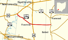
State Route 286 (SR 286) is a 9.97-mile-long (16.05 km) east–west state highway in the southwestern portion of the U.S. state of Ohio. The western terminus of SR 286 is at U.S. Route 50 (US 50) nearly five miles (8.0 km) southwest of the village of Fayetteville. Its eastern terminus is at SR 134 approximately seven and a quarter miles (11.7 km) northwest of Sardinia.
History
The SR 286 designation was applied in 1931. The highway originally ran from its present junction with US 68 (at the time the concurrency of SR 10 and SR 53) to its eastern terminus at SR 134.[4] [5]
In 1938, SR 286 was extended west-northwest along a previously un-numbered roadway to its present western terminus at US 50 southwest of Fayetteville.[6][7]
Major intersections
| County | Location | mi[1][2][3] | km | Destinations | Notes |
|---|---|---|---|---|---|
| Clermont | Jackson Township | 0.00 | 0.00 | ||
| Brown | Green Township | 5.16 | 8.30 | ||
| Highland | Clay Township | 9.97 | 16.05 | ||
| 1.000 mi = 1.609 km; 1.000 km = 0.621 mi | |||||
References
- 1 2 Ohio Department of Transportation. "Technical Services Straight Line Diagrams: SR 286, Clermont County" (PDF). Retrieved 2011-09-26.
- 1 2 Ohio Department of Transportation. "Technical Services Straight Line Diagrams: SR 286, Brown County" (PDF). Retrieved 2011-09-26.
- 1 2 Ohio Department of Transportation. "Technical Services Straight Line Diagrams: SR 286, Highland County" (PDF). Retrieved 2011-09-26.
- 1 2 Map of Ohio Showing State Highway System (MrSID) (Map). Cartography by ODOH. Ohio Department of Highways. 1930. Retrieved 2011-09-26.
- 1 2 Map of Ohio Showing State Highway System (MrSID) (Map). Cartography by ODOH. Ohio Department of Highways. 1931. Retrieved 2011-09-26.
- ↑ Official Ohio Highway Map (MrSID) (Map). Cartography by ODOH. Ohio Department of Highways. 1937. Retrieved 2011-09-26.
- ↑ Official Ohio Highway Map (MrSID) (Map). Cartography by ODOH. Ohio Department of Highways. 1938. Retrieved 2011-09-26.
This article is issued from Wikipedia - version of the 9/12/2014. The text is available under the Creative Commons Attribution/Share Alike but additional terms may apply for the media files.