Ohio State Route 542
| ||||
|---|---|---|---|---|
 | ||||
| Route information | ||||
| Maintained by ODOT | ||||
| Length: | 15.81 mi[1] (25.44 km) | |||
| Existed: | 1937 – present | |||
| Major junctions | ||||
| South end: |
| |||
|
| ||||
| North end: |
| |||
| Location | ||||
| Counties: | Carroll | |||
| Highway system | ||||
| ||||

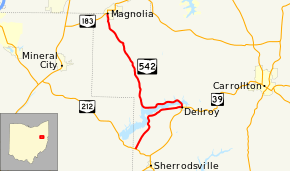
State Route 542 (SR 542) is a state highway in western Carroll County, within the eastern side of Ohio. The route runs 15.8 miles (25.4 km) long and connects SR 212 near Sherrodsville to Magnolia at SR 183 by way of Dellroy and Atwood Lake.
Route description
SR 542 begins at an intersection with SR 212 in Monroe Township. The route heads north-northeast on a slight incline. Near the apex of this incline, the route winds around some hills and gets within the view of Atwood Lake. As the road curves to the east, entrances to numerous villages on the lake shoreline line the highway. SR 542 enters the village limits of Dellroy on Main Street and reaches a signalized intersection with Smith Avenue. At this intersection, SR 39 heads to the south on Smith Avenue and east on Main Street; SR 542 heads to the west on Main and to the north on Smith. To the north of the intersection, the route passes through a small business district, residential homes, and a small park before curving northwest and crossing Atwood Lake on a causeway. After the causeway, SR 542 turns due west and crosses more small tributaries of the lake and passes near more small villages surrounding the lake. Before crossing the last bridge over the lake, the route turns north into hilly terrain. Shortly after entering the village of Magnolia on Main Street, the route ends at an intersection of Main Street and Carrollton Street. SR 183 heads west on Carrollton Street and continues north on Main Street from this point.[2] The intersection is located about 0.03 miles (48 m) south of the Carroll–Stark county line.[3]
History
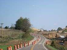
SR 542 was first designated on an alignment between Dellroy and Magnolia in 1937.[4][5] The route at its designation was a gravel road but was fully paved by 1955.[6] This alignment would remain until 1967 when SR 542 was extended south of Dellroy to SR 212.[7][8] In 2014, a straightening project was initiated about two and a half miles (4.0 km) south of Magnolia on a sharp curve with a descent in elevation.[9] The 2,000-foot-long (610 m) realignment project was completed on November 17, 2014.[10] A 0.21-mile-long (0.34 km) segment of the old road, officially designated SR 542-J remains to serve existing access points.[1]
Major intersections
The entire route is in Carroll County.
| Location | mi[1] | km | Destinations | Notes | |
|---|---|---|---|---|---|
| Monroe Township | 0.00 | 0.00 | |||
| Dellroy | 5.19 | 8.35 | |||
| Magnolia | 15.81 | 25.44 | |||
| 1.000 mi = 1.609 km; 1.000 km = 0.621 mi | |||||
References
- 1 2 3 "DESTAPE - Pickaway County" (PDF). Ohio Department of Transportation. June 24, 2015. Retrieved January 1, 2016.
- ↑ Google (October 23, 2013). "Ohio State Route 542" (Map). Google Maps. Google. Retrieved October 23, 2013.
- ↑ ODOT. "Technical Services Straight Line Diagrams - SR 183 - Carroll County" (PDF). Retrieved October 23, 2013.
- ↑ 1936 Official Highway Map (MrSID) (Map). Cartography by John Jaster, Jr., Director. Ohio Department of Highways. 1936. Retrieved August 19, 2013.
- ↑ Official Ohio Highway Map 1937 (MrSID) (Map). Cartography by John Jaster, Jr., Director. ODOH. 1937. Retrieved August 19, 2013.
- ↑ Ohio Highway Map 1955 (MrSID) (Map). Cartography by S.O. Linzell, Director. ODOH. 1955. Retrieved September 23, 2013.
- ↑ 1967 Official Highway Map (MrSID) (Map). Cartography by P.E. Masheter, Director. ODOH. 1967. Retrieved September 22, 2013.
- ↑ 1969 Official Ohio Highway Map (MrSID) (Map). Cartography by P.E. Masheter, Director. ODOH. 1969. Retrieved September 22, 2013.
- ↑ "SR 542 safety improvement project to begin south of Magnolia". ODOT. 2014-04-14.
- ↑ "State Route 542 traffic to be moved onto new alignment Monday" (Press release). ODOT. November 12, 2014. Retrieved January 1, 2016.
External links
| Wikimedia Commons has media related to Ohio State Route 542. |