Ohio State Route 792
| ||||
|---|---|---|---|---|
 | ||||
| Route information | ||||
| Maintained by ODOT | ||||
| Length: | 5.53 mi[1] (8.90 km) | |||
| Existed: | 1937 – present | |||
| Major junctions | ||||
| South end: |
| |||
| North end: |
| |||
| Location | ||||
| Counties: | Washington, Morgan | |||
| Highway system | ||||
| ||||

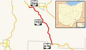
State Route 792 (SR 792) is a north–south state highway located in southeastern Ohio. The southern terminus of SR 792 is at a T-intersection with SR 676 approximately seven miles (11 km) east of Chesterhill. Its northern terminus is at SR 266 nearly one and a half miles (2.4 km) west of Stockport.
Route description
SR 792 runs through an extremely small portion of northwestern Washington County and part of the southern end of Morgan County. The state highway is not included in the National Highway System.[2]
History
First established in 1937 along the path that is currently occupies between SR 676 and SR 266, SR 792 has not experienced any significant changes to its routing since its inception.[3][4]
Major intersections
| County | Location | mi[1] | km | Destinations | Notes |
|---|---|---|---|---|---|
| Washington | Wesley Township | 0.00 | 0.00 | ||
| Morgan | Windsor Township | 5.53 | 8.90 | ||
| 1.000 mi = 1.609 km; 1.000 km = 0.621 mi | |||||
References
- 1 2 "DESTAPE". Ohio Department of Transportation. June 24, 2015. Retrieved November 9, 2015.
- ↑ National Highway System: Ohio (PDF) (Map). Federal Highway Administration. December 2003. Retrieved 2010-08-30.
- ↑ Ohio State Map (Map). Ohio Department of Transportation. 1936.
- ↑ Ohio State Map (Map). Ohio Department of Transportation. 1937.
This article is issued from Wikipedia - version of the 11/28/2015. The text is available under the Creative Commons Attribution/Share Alike but additional terms may apply for the media files.