Ohio State Route 266
| ||||
|---|---|---|---|---|
 | ||||
| Route information | ||||
| Maintained by ODOT | ||||
| Length: | 13.86 mi[1] (22.31 km) | |||
| Existed: | 1926 – present | |||
| Major junctions | ||||
| West end: |
| |||
| East end: |
| |||
| Location | ||||
| Counties: | Morgan | |||
| Highway system | ||||
| ||||


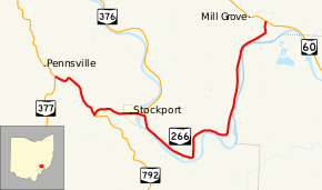
State Route 266 (SR 266, OH 266) is an east–west state highway located in the southeastern portion of Ohio. State Route 266's western terminus is at a Y-intersection with State Route 377 nearly 3.5 miles (5.6 km) northwest of Stockport, and its eastern terminus is at another Y-intersection, this time with State Route 60 approximately 4.5 miles (7.2 km) northwest of Beverly.
Located in southeastern Morgan County, State Route 266 was first designated in the middle of the 1920s along its current routing. The highway serves the village of Stockport. From the State Route 376 intersection to its eastern terminus at State Route 60, State Route 266 generally straddles the northern banks of the Muskingum River.
Route description
The entirety of State Route 266 is within the confines of southeastern Morgan County. There is no portion of State Route 266 that is included within the National Highway System.[2]
History
State Route 266 was first designated in 1926 along the routing within southeastern Morgan County that it occupies to this day. There have been no significant changes to the route since its inception.[3][4]
Major intersections
The entire route is in Morgan County.
| Location | mi[1] | km | Destinations | Notes | |
|---|---|---|---|---|---|
| Penn Township | 0.00 | 0.00 | |||
| Windsor Township | 2.35 | 3.78 | Northern terminus of SR 792 | ||
| 4.40 | 7.08 | Southern terminus of SR 376 | |||
| Center Township | 13.86 | 22.31 | |||
| 1.000 mi = 1.609 km; 1.000 km = 0.621 mi | |||||
References
- 1 2 Ohio Department of Transportation. "Technical Services Straight Line Diagrams" (PDF). Retrieved 2013-09-03.
- ↑ National Highway System: Ohio (PDF) (Map). Federal Highway Administration. December 2003. Retrieved 2010-07-23.
- ↑ Ohio State Map (Map). Ohio Department of Transportation. 1925.
- ↑ Ohio State Map (Map). Ohio Department of Transportation. 1926.