Ohio State Route 81
| ||||
|---|---|---|---|---|
 | ||||
| Route information | ||||
| Maintained by ODOT | ||||
| Length: | 70.489 mi[1] (113.441 km) | |||
| Existed: | 1927 – present | |||
| Major junctions | ||||
| West end: |
| |||
|
| ||||
| East end: |
| |||
| Location | ||||
| Counties: | Van Wert, Allen, Hardin | |||
| Highway system | ||||
| ||||

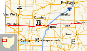
State Route 81 (SR 81) is an east–west route in western Ohio. Its western terminus is at the Indiana state line near Willshire (the route continues as State Road 124), and its eastern terminus is at SR 53 in Patterson. The route also goes through or close to the towns of Elgin, Lima, Ada, and Dunkirk.[2]
History
SR 81 was certified by 1927. It was originally routed from Ada to Patterson on the former northernmost section of the now-defunct SR 69. At the time of SR 81's current designation, SR 69 was rerouted to Mount Cory (this route is now part of SR 235).[3][4] SR 81 was extended to the Indiana state line in 1940 along formerly unnumbered roads from Ada to Lima and along the route of the now-defunct SR 704 (which was created in 1937[5]) from Lima to the state line.[6][7] No major changes have occurred to the routing since then.
From 1923 to 1926, SR 81 was a short route in northeastern Ohio between Brentwood Lake and Twinsburg. In 1926, the route became part of SR 82.[8][3][4]
Major junctions
| County | Location | mi[1] | km | Destinations | Notes |
|---|---|---|---|---|---|
| Van Wert | Willshire Township | 0.000 | 0.000 | Indiana state line | |
| Willshire | 0.422 | 0.679 | Western end of US 33 concurrency | ||
| 0.633 | 1.019 | Eastern end of US 33 concurrency; eastern end of SR 49 concurrency | |||
| Willshire Township | 0.730 | 1.175 | Western end of SR 49 concurrency | ||
| Liberty Township | 9.123 | 14.682 | |||
| 11.712 | 18.849 | ||||
| Jennings Township | 20.364 | 32.773 | |||
| Allen | Spencer–Amanda township line | 24.887– 24.935 | 40.052– 40.129 | Western end of SR 66 concurrency | |
| Amanda Township | 25.175 | 40.515 | Eastern end of SR 66 concurrency | ||
| Lima | 37.587 | 60.490 | Western end of SR 309 concurrency | ||
| 38.467 | 61.907 | Western end of SR 65 southbound concurrency | |||
| 38.519 | 61.990 | Western end of SR 65 northbound concurrency | |||
| 38.711 | 62.299 | Eastern end of SR 65 southbound / SR 309 eastbound concurrency | |||
| 38.762 | 62.381 | Eastern end of SR 65 northbound / SR 309 westbound concurrency | |||
| Bath Township | 40.742 | 65.568 | Exit 127 (I-75) | ||
| Hardin | Ada | 54.248 | 87.304 | ||
| Dunkirk | 64.372 | 103.597 | |||
| Patterson | 70.489 | 113.441 | |||
1.000 mi = 1.609 km; 1.000 km = 0.621 mi
| |||||
References
- 1 2 "Division of Planning - Office of Technical Services - Destape files". ODOT. July 16, 2013. Retrieved February 15, 2014 — Van Wert County, Allen County, Hardin County
- ↑ Google (February 15, 2014). "Ohio State Route 81" (Map). Google Maps. Google. Retrieved February 15, 2014.
- 1 2 Map of Ohio Showing State Routes (MrSID) (Map). Cartography by G.F. Schlesinger, Director. Ohio Division of Highways. 1926. Retrieved September 22, 2013.
- 1 2 Map of Ohio Showing State Routes (MrSID) (Map). Cartography by G.F. Schlesinger, Director. ODOH. 1927. Retrieved September 22, 2013.
- ↑ Official Ohio Highway Map 1937 (MrSID) (Map). Cartography by John Jaster, Jr., Director. ODOH. 1937. Retrieved August 19, 2013.
- ↑ Ohio Highway Map 1939 (MrSID) (Map). Cartography by Robt. S. Beightler, Director. ODOH. 1939. Retrieved August 19, 2013.
- ↑ Ohio Highway Map 1940 (MrSID) (Map). Cartography by Robt. S. Beightler, Director. ODOH. 1940. Retrieved August 18, 2013.
- ↑ Map of Ohio Showing State Routes (MrSID) (Map). Cartography by L.A. Boulay, Director. ODOH. 1923. Retrieved August 18, 2013.