Ohio State Route 53
| ||||
|---|---|---|---|---|
 | ||||
| Route information | ||||
| Maintained by ODOT | ||||
| Length: | 92.75 mi[1] (149.27 km) | |||
| Major junctions | ||||
| South end: |
| |||
|
| ||||
| North end: | Catawba Island, near Port Clinton | |||
| Location | ||||
| Counties: | Hardin, Wyandot, Seneca, Sandusky, Ottawa | |||
| Highway system | ||||
| ||||


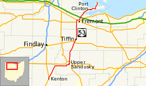
State Route 53 is a north–south state highway in the U.S. state of Ohio, generally oriented in the north–south direction. Its southern terminus is at the beginning of the U.S. 68/S.R. 67 concurrency in Kenton, Ohio, and its northern terminus is on Catawba Island in Ottawa County, north of Port Clinton.
Route description
From Kenton, State Route 53 moves northeast to Forest, then continues eastward to Upper Sandusky. It then moves north through the small towns of Tymochtee and McCutchenville before entering Tiffin. The route then moves due north to Fremont, where it joins a four-route bypass around the city with U.S. Routes 6 and 20 and State Route 19. From its northern bypass interchange, it continues on a northeast heading, following the northern coastline of Sandusky Bay to Port Clinton, where it joins State Route 2 on a bypass around that city. From its eastern bypass interchange, State Route 53 heads north onto Catawba Island.
History
State Route 53 was an original state highway which stretched from the Ohio River at Higginsport to Port Clinton. The route followed that of current State Route 221 to Georgetown, then followed the route currently followed by U.S. Route 68 to Kenton, then along its current route into Port Clinton. The route entered Port Clinton and truncated at State Route 163.
Before the Fremont bypass was certified, State Route 53 was routed along the Sandusky River through Old Fort into Fremont.
In 1929, State Route 53 was routed through the town of St. Martin, a town it originally bypassed. This reroute was reversed in 1931 and is now State Route 251.
In 1933, State Route 53's southern terminus was moved to Kenton when U.S. Route 68 was certified.
In 1946, State Route 53's northern terminus was extended to Catawba Island. It shared a route with State Route 163 for approximately five miles, then split north to the island. This route was formerly the southern portion of State Route 357.
In 1969, State Route 53 was routed along the State Route 2 bypass with an interchange approximately 2 miles (3.2 km) south of its split with State Route 163.
Major junctions
| County | Location | mi[1] | km | Exit | Destinations | Notes |
|---|---|---|---|---|---|---|
| Hardin | Kenton | 0.00 | 0.00 | |||
| 0.10 | 0.16 | Southern end of SR 31 concurrency | ||||
| 0.48 | 0.77 | |||||
| 0.55 | 0.89 | |||||
| 0.63 | 1.01 | Northern end of SR 31 concurrency | ||||
| Patterson | 10.78 | 17.35 | Eastern terminus of SR 81 | |||
| Forest | 12.39 | 19.94 | Southern end of SR 37 concurrency | |||
| Wyandot | Jackson Township | 13.73 | 22.10 | Northern end of SR 37 concurrency | ||
| Jackson–Mifflin township line | 17.30 | 27.84 | Southern terminus of SR 293 | |||
| Upper Sandusky | 25.36 | 40.81 | Southern end of SR 67 concurrency | |||
| 26.01 | 41.86 | Southern end of SR 199 concurrency | ||||
| 26.17 | 42.12 | Northern end of SR 199 concurrency | ||||
| Upper Sandusky–Crane Township municipal line | 28.20– 28.38 | 45.38– 45.67 | Interchange | |||
| 28.54 | 45.93 | Northern end of SR 67 concurrency | ||||
| Tymochtee Township | 34.04 | 54.78 | Southern end of SR 103 concurrency | |||
| 34.59 | 55.67 | Northern end of SR 103 concurrency | ||||
| 37.63 | 60.56 | Southern terminus of SR 587 | ||||
| Seneca | Hopewell Township | 45.61 | 73.40 | |||
| Tiffin | 47.00 | 75.64 | Western terminus of SR 103; southern end of SR 103 westbound concurrency | |||
| 47.11 | 75.82 | Northern end of SR 103 westbound concurrency | ||||
| 47.96 | 77.18 | Northern terminus of SR 100 | ||||
| Sandusky | Ballville Township | 59.55 | 95.84 | Eastern terminus of SR 12 | ||
| Ballville–Sandusky township line | 63.05 | 101.47 | Southern end of US 6 concurrency | |||
| Sandusky Township | 64.67– 65.12 | 104.08– 104.80 | 98 | Interchange; southern end of US 20 concurrency | ||
| Southern end of freeway | ||||||
| Fremont | 66.23– 66.38 | 106.59– 106.83 | 94 | Southern end of SR 19 concurrency | ||
| 66.88– 67.92 | 107.63– 109.31 | 101 | Northern end of US 6 / US 20 / SR 19 concurrencies | |||
| Northern end of freeway | ||||||
| Rice Township | 70.07– 70.21 | 112.77– 112.99 | Exit 91 (Ohio Turnpike) | |||
| 73.70 | 118.61 | Eastern terminus of SR 523 | ||||
| Ottawa | Bay Township | 80.01– 80.27 | 128.76– 129.18 | 117 | Southern end of SR 2 concurrency | |
| Southern end of freeway | ||||||
| Portage Township | 83.81– 84.30 | 134.88– 135.67 | 121A–B | |||
| 86.19– 86.69 | 138.71– 139.51 | 124 | Northern end of SR 2 concurrency | |||
| Northern end of freeway | ||||||
| 87.82 | 141.33 | |||||
| Catawba Island Township | 92.75 | 149.27 | East Water Street / Miller Boat Line – South Bass Island | |||
1.000 mi = 1.609 km; 1.000 km = 0.621 mi
| ||||||