Ohio State Route 835
| ||||
|---|---|---|---|---|
 | ||||
| Route information | ||||
| Maintained by ODOT | ||||
| Length: | 6.59 mi[1] (10.60 km) | |||
| Existed: | 1987 – present | |||
| Major junctions | ||||
| West end: |
| |||
| East end: |
| |||
| Location | ||||
| Counties: | Montgomery, Greene | |||
| Highway system | ||||
| ||||

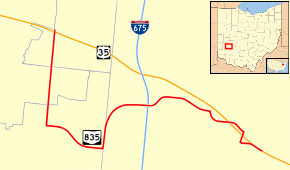
State Route 835 is an east–west state highway in the southwestern portion of the U.S. state of Ohio.
Route description
State Route 835 connects to U.S. Route 35 on both ends, starting at that route's interchange with Woodman Drive (C-74) approximately 4½ miles east of Downtown Dayton. From there, the route occupies a portion of Woodman Drive for about 1.5 miles (2.4 km) south to Patterson Road on which the route heads east for about a mile. From there it turns north onto Research Boulevard which gradually turns to the east and follows to the route's terminus at the U.S. Route 35 interchange with North Fairfield Road (C-9) in Beavercreek. State Route 835 does not intersect with any other state highways.[1][2]
Major intersections
| County | Location | mi[1] | km | Destinations | Notes |
|---|---|---|---|---|---|
| Montgomery | Riverside | 0.00– 0.08 | 0.00– 0.13 | Western terminus | |
| Greene | Beavercreek | 5.919– 6.586 | 9.526– 10.599 | Eastern terminus | |
| 1.000 mi = 1.609 km; 1.000 km = 0.621 mi | |||||
References
- 1 2 3 Ohio Department of Transportation. "Technical Services DESTAPE". Retrieved 2013-12-22.
- ↑ Google (2013-12-22). "Ohio State Route 835" (Map). Google Maps. Google. Retrieved 2013-12-22.
This article is issued from Wikipedia - version of the 6/23/2016. The text is available under the Creative Commons Attribution/Share Alike but additional terms may apply for the media files.