Ohio State Route 844
| ||||
|---|---|---|---|---|
| McClernon Memorial Skyway | ||||
 | ||||
| Route information | ||||
| Maintained by ODOT | ||||
| Length: | 2.40 mi[1] (3.85 km) | |||
| Existed: | 1989[2] – present | |||
| Major junctions | ||||
| South end: |
| |||
|
| ||||
| North end: | Wright-Patterson Air Force Base near Fairborn | |||
| Location | ||||
| Counties: | Greene | |||
| Highway system | ||||
| ||||

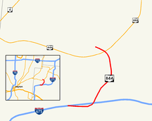
State Route 844 (SR 844) is a 2.395-mile (3.854 km) state route that runs between Beavercreek and Wright-Patterson Air Force Base in the US state of Ohio. The north–south signed route is a spur freeway which mainly passes through government-owned properties. For some of its path, SR 844 passes through Wright State University. The highway was first signed in 1995 on the same alignment as today. SR 844 replaced the SR 444A designation of the highway, which dated back to 1989.
Route description
| County Log Point | Volume | ||||
|---|---|---|---|---|---|
| 0.746 | 16,660 | ||||
| 1.2 | 20,520 | ||||
| 1.85 | 15,530 | ||||
| 2.2 | 8,590 | ||||
SR 844 begins at a partial interchange with Interstate 675 (I-675). The route heads northeast as a four-lane controlled-access highway, passing under North Fairfield Road. The road has a partial interchange with Colonel Glenn Highway, before passing on the southeast and east sides of Wright State University. The highway curves due north, having an interchange with University Boulevard. After the interchange with University Boulevard, the road curves northwest, passing over SR 444. Followed by an interchange with SR 444, SR 844 ends at Gate 15A of Wright-Patterson Air Force Base.[4][5][6]
SR 844 is signed as "McClernon Memorial Skyway",[7] after the late Brigadier General Glen J. McClernon. McClernon had been base commander[8][9] during the time the university was being established[10]—partially on land deeded to it by the Air Force base[11]—and also had been a two-term mayor of Fairborn.[12]
The entire length of SR 844 is part of the National Highway System, a system of routes important to the nation's economy, mobility and defense.[13][14] The highway is maintained by the Ohio Department of Transportation (ODOT).[15]
History
SR 844 was originally SR 444A, which opened by 1989.[2] After a public comment period in 1994,[16] ODOT changed the number to "844" by 1995.[17] Although legally designated as "McClernon-Skyway Memorial Drive" on September 22, 1989,[18] SR 844 is both signed and recognized by the state as "McClernon Memorial Skyway".[7]
Future
There are plans to add a ramp from northbound SR 844 to northbound SR 444, and to add a ramp from northbound SR 444 to southbound SR 844.[15] As of October 2013, the status and funding for this project are unknown.
Major junctions
The entire route is in Greene County.
| Location | mi[1] | km | Exit | Destinations | Notes |
|---|---|---|---|---|---|
| Beavercreek | 0.00 | 0.00 | Southbound exit and northbound entrance; exit 17 on I-675 | ||
| Fairborn | 1.013 | 1.630 | 1 | Colonel Glenn Highway | Southbound exit and northbound entrance |
| 1.448– 2.043 | 2.330– 3.288 | 2 | University Boulevard[19] | Access to Wright State University[20] | |
| 2.100 | 3.380 | 3 | Partial cloverleaf interchange; no access from SR 444 to SR 844 northbound | ||
| Wright-Patterson Air Force Base | 2.395 | 3.854 | Wright-Patterson Air Force Base Gate 15A | At-grade intersection; access pass required[21] | |
| 1.000 mi = 1.609 km; 1.000 km = 0.621 mi | |||||
References
- 1 2 Ohio Department of Transportation. "Technical Services DESTAPE" (PDF). Retrieved November 2, 2013.
- 1 2 Ohio State Map (Map). Ohio Department of Transportation. 1989. Retrieved October 4, 2013.
- ↑ Staff. "Transportation Information Mapping System". Ohio Department of Transportation. Retrieved October 4, 2013.
- ↑ Google (February 22, 2013). "Overview of Ohio State Route 844" (Map). Google Maps. Google. Retrieved February 22, 2013.
- ↑ Ohio Highway Map (PDF) (Map). Cartography by ODOT. Ohio Department of Transportation. 2011. Retrieved February 22, 2013.
- ↑ Map of Greene County, Ohio (PDF) (Map). Cartography by ODOT. Ohio Department of Transportation. December 2008. Retrieved February 22, 2013.
- 1 2 "Maintenance Administration, Ohio Hauling Permits: Route Mileposts". Ohio Department of Transportation. Archived from the original on October 19, 2013. Retrieved October 19, 2013.
- ↑ "Brigadier General Glen J. McClernon". United States Air Force. April 1, 1968. Retrieved August 18, 2013.
- ↑ "Factsheets: 88 Air Base Wing (AFMC)". Air Force Historical Research Agency. April 27, 2010. Retrieved November 7, 2011.
- ↑ "Book I: The Founding" (PDF). Wright State University. Retrieved November 7, 2011.
- ↑ "History: Special Collections & Archives; Historical Background". Wright Brothers Collection. Wright State University. Retrieved November 7, 2011.
- ↑ "Glen McClernon obituary". The Blade. Toledo, OH. August 20, 1984. p. 8. Retrieved November 7, 2011.
- ↑ National Highway System: Dayton, Ohio (PDF) (Map). Federal Highway Administration. October 1, 2012. Retrieved March 7, 2013.
- ↑ Natzke, Stefan; Neathery, Mike; Adderly, Kevin (September 26, 2012). "What is the National Highway System?". National Highway System. Federal Highway Administration. Retrieved February 22, 2013.
- 1 2 Office of Technical Services. "SR 844, Greene County" (PDF). Straight Line Diagrams. Ohio Department of Transportation. Retrieved November 2, 2010.
- ↑ "Ohio proposes renaming road". Dayton Daily News. June 15, 1994. Archived from the original on December 3, 2013. Retrieved May 17, 2008.
- ↑ Ohio State Map (Map). Ohio Department of Transportation. 1995. Retrieved October 4, 2013.
- ↑ Ohio General Assembly. "5533.43 McClernon-Skyway memorial drive". Ohio Revised Code. Retrieved November 7, 2011.
- ↑ Engineering Division (May 2012). "City of Fairborn, Greene County Ohio, Street Map" (PDF) (PDF). City of Fairborn. Retrieved October 19, 2013.
- ↑ "Color Campus Map". Wright State University. Retrieved September 24, 2012.
- ↑ "ID Cards & General Base Information". Wright-Patterson Air Force Base. Retrieved October 5, 2013.