Ojuelos de Jalisco
| Ojuelos de Jalisco | ||
|---|---|---|
| Municipality and city | ||
| ||
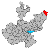 Location of the municipality in Jalisco | ||
|
Ojuelos de Jalisco Location in Mexico | ||
| Coordinates: 21°52′N 101°35′W / 21.867°N 101.583°W | ||
| Country |
| |
| State | Jalisco | |
| Garrison built | 1569 | |
| Government | ||
| • Mayor / Presidente Municipal | David Gonzalez | |
| Area | ||
| • Total | 1,156.71 km2 (446.61 sq mi) | |
| Population (2010) | ||
| • Total | 30,097 | |
| Time zone | Central Standard Time (UTC-6) | |
| • Summer (DST) | Central Daylight Time (UTC-5) | |
| Postcode | 47540 | |
| Area code(s) | 496 | |

Ojuelos de Jalisco is a colonial city and municipality in the state of Jalisco, Mexico. The town's 1990 population was 7,265,[1] although by the year 2010 it had increased to 11,881.[2]
It sits at the junction of Mexico Highways 51, 70, and 80. The municipality is located in the North-Central region of Mexico. It is bordered by 3 states: Guanajuato, Zacatecas and Aguascalientes. Also, it is located at a very closed proximity of the state of San Luis Potosi. All of the above makes of Ojuelos one of the municipalities with the most borders in Mexico. It also borders with the Lagos de Moreno municipality in the state of Jalisco.
History
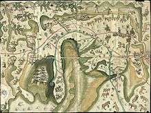
The city was founded by Spanish conquistador Pedro Carrillo Davila in 1569, as a fortification or military garrison to protect travelers against the Chichimecas warriors. The fortification of Ojuelos was one of the seven ones built at the request of the Viceroy Martín Enriquez de Almanza in the important route Mexico-Zacatecas which later became the Camino Real de Tierra Adentro. The fortification in Ojuelos was the first being built and it is only one still in place. The decision to build the seven fortifications was made by Viceroy Enriquez de Almanza in response to deadly attacks made by Chichimecas commanded by their legendary leader Maxorro.
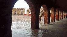
Ojuelos has a significant value in Colonial history in Mexico and North America, since its fortification is the only one which has survived to present day keeping its main structure as originally built in 1569. Currently, it houses the offices of the City Hall and a Library.

In 1874, Ojuelos was designated as Municipality by Ignacio L. Vallarta, Governor of the State of Jalisco, after a long border dispute with the state of Zacatecas.
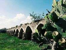
In 2010, Ojuelos was declared a World Heritage Site by UNESCO as part of the Camino Real de Tierra Adentro 2010.[3] Camino Real de Tierra Adentro was the Royal Inland Road, also known as the Silver Route. This UNESCO's World Heritage Site consists of a series of sites lying along a 1400 km section of this 2600 km route, that extends north from Mexico City to Texas and New Mexico, United States of America. The route was actively used as a trade route for 300 years, from the mid-16th to the 19th centuries, mainly for transporting silver extracted from the mines of Zacatecas, Guanajuato and San Luis Potosí, and mercury imported from Europe. Although it is a route that was motivated and consolidated by the mining industry, it also fostered the creation of social, cultural and religious links in particular between Spanish and Amerindian cultures. In the case of Ojuelos, the specific sites inscribed in the UNESCO Roster are the historic downtown of Ojuelos (Site 1351-018) including "El Fuerte", "El Parian" and other historic buildings, and the Bridge of Ojuelos "El Puente de Ojuelos" (Site 1351-019).[4]
Tourism
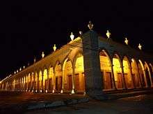
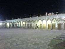
Among other touristic attractions, Ojuelos also has a plaza, El Parian, which is surrounded by 102 Gothic arches. El Parian was designed at the end of the 19th century by Luis G. Maciel.
Notes
- ↑ http://www.bartleby.com/69/14/O01014.html
- ↑ http://www.iieg.gob.mx/contenido/Municipios/OjuelosdeJalisco.pdf
- ↑ "Camino Real de Tierra Adentro - World Heritage List". UNESCO. Retrieved 2010-08-05.
- ↑ http://whc.unesco.org/en/list/1351
External links

Coordinates: 21°52′N 101°35′W / 21.867°N 101.583°W