Oléron
|
Aerial photograph of Oléron | |
 Île d'Oléron | |
| Geography | |
|---|---|
| Location | Atlantic Ocean |
| Coordinates | 45°54′N 1°18′W / 45.9°N 1.3°WCoordinates: 45°54′N 1°18′W / 45.9°N 1.3°W |
| Area | 174 km2 (67 sq mi) |
| Length | 30 km (19 mi) |
| Width | 8 km (5 mi) |
| Highest elevation | 34 m (112 ft) |
| Administration | |
|
France | |
| Region | Nouvelle-Aquitaine |
| Department | Charente-Maritime |
| Arrondissement | Rochefort |
| Largest settlement | Saint-Pierre-d'Oléron (pop. 6,687) |
| Demographics | |
| Population | 21,871 (2010) |
| Pop. density | 126 /km2 (326 /sq mi) |
| Ethnic groups | French people |
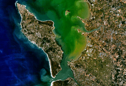
Île d'Oléron (pronounced: [il doleʁɔ̃]) is an island off the Atlantic coast of France (due west of Rochefort), on the southern side of the Pertuis d'Antioche strait.
It is the second largest island of Metropolitan France, after Corsica.
History
In the 7th and 8th century, the island, along with Ré, formed the Vacetae Insulae or Vacetian Islands, according to the Cosmographia.[1] Vaceti being another name for the Vascones, the reference is evidence to Basque (Gascon) settlement or control of the islands by that date.
It was at Oléron in about 1152 to 1160 that Eleanor of Aquitaine introduced the first 'maritime' or 'admiralty' laws in that part of the world: the Rolls of Oleron. In 1306, Edward I of England granted the island to his son, Edward II, as part of the Duchy of Aquitaine.
On 20 March 1586, the island was taken by Agrippa d'Aubigné.
Geography
The island has an area of about 174 km2. It is a fertile and well cultivated island on the Atlantic coast of France, that is on the Bay of Biscay.
The climate is generally mild (maritime temperate) with sufficient but not excessive rainfall, but with probably from 3 to 15 days of intense heat in the summer months of July and August, mostly grouped.[2]
Administration
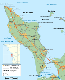
Administratively, the island belongs to the Charente-Maritime département, in the Nouvelle-Aquitaine région. The island is divided into 8 communes:
- La Brée-les-Bains
- Le Château-d'Oléron
- Dolus-d'Oléron
- Le Grand-Village-Plage
- Saint-Denis-d'Oléron
- Saint-Georges-d'Oléron (includes Boyardville)
- Saint-Pierre d'Oléron
- Saint-Trojan-les-Bains
The island has about 22,000 inhabitants.
Transportation
Since 1966, the island has been connected to the mainland by a road bridge. With a length of 2,862 m (9,390 ft) between abutments, it was the longest bridge in France at the time of construction. It is now the third one, after the Saint-Nazaire bridge and the Île de Ré bridge. It has been toll-free since 1991.
On the island itself, the easiest way to get around is by car or by bicycle. During the last ten years, a network of 110 kilometers of bicycle paths have been built. These bicycle lanes are mostly car-free.
Tourism
As a large Atlantic island only 3 kilometres off the Aquitanian coast of France, Oléron is a popular tourist destination. Several companies operate boat trips from the towns of Boyardville and Saint-Denis to the nearby Ile d'Aix, La Rochelle, and past the Fort Boyard. The port towns are frequently visited by tourists, especially the village of La Cotiniere. This village is the base for a hundred trawlers who sell their fish every day at 05:00 and 16:00h. La Cotiniere was the first fishing port in the department of Charente-Maritime, and the 8th of France.[3]
Notes
- ↑ Collins' book, p. 214.
- ↑ http://www.ile-oleron-marennes.com/ by La Maison du Tourisme de l'île d'Oléron et du bassin de Marennes 2007
- ↑ fr:Île d'Oléron
Sources
- Collins, Roger. "The Vaccaei, the Vaceti, and the rise of Vasconia." Studia Historica VI. Salamanca, 1988. Reprinted in Roger Collins, Law, Culture and Regionalism in Early Medieval Spain. Variorum, 1992. ISBN 0-86078-308-1.
External links
| Wikimedia Commons has media related to Île d'Oléron. |