Olmsted Island


Olmsted Island is a small island in the middle of the Potomac River in the U.S. state of Maryland, near Great Falls which is a part of C & O Canal National Historical Park, located across the river from Great Falls Park. It is a part of Potomac, Maryland.
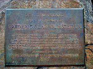
Named for Frederick Law Olmsted, Jr., the landscape architect and preservationist whose famous father designed New York's Central Park, the small island is a bedrock terrace forest that supports rare, threatened and endangered plant species.[1]
The island is very rocky and has steep cliffs that face the river, where it has been eroded over time. It also has trees and vegetation. One might also spy a heron, small lizard or wild goose here. The total area of the island (estimating from calibrated satellite footage) is no more than 0.2 square kilometers. A fenced-in wooden tourist walkway winds along the southern part of the island. For the purpose of protecting the island's natural wildlife, visitors are not allowed to leave the tourist walkway. The tourist walkway eventually ends in a scenic overlook platform (see images 1 and 2) that has a beautiful view of the Great Falls of the Potomac River (see image 3).
"Hurricane Agnes washed away all the woody shrubs and trees in 1972," says R. Harrison Wiegand, a regional ecologist for the Wildlife and Heritage Service of the Maryland Department of Natural Resources. "The next big flood will wash them away again. The floods constantly change things. You may see a rare species in one area, then the floods will come through and wash it out. Some other plants will grow there instead. This is one of the most biologically diverse habitats within the whole national park system."[2]
References
- ↑ Owens, Donna M. "Maryland side of Great Falls is a scenic wonder". Baltimore Sun. Retrieved 2007-08-21.
- ↑ Cohn, Jeffrey P. "The Wildest Urban River: Potomac River Gorge" (PDF). National Park Service. Retrieved 2007-08-21.
External links
- Satellite imagery of Olmsted Island on Google Maps. If you look carefully towards the southern end of the island you can see the tourist walkway winding its way and finally ending in the overlook platform at Great Falls.
Coordinates: 38°59′54″N 77°15′00″W / 38.9983°N 77.2500°W