Onizuka Air Force Station
Onizuka Air Force Station | |
|---|---|
| Part of Air Force Space Command (AFSPC) | |
| Moffett Federal Airfield, California | |
|
Onizuka Air Force Station | |
| Coordinates | 37°24′27.35″N 122°1′36.40″W / 37.4075972°N 122.0267778°WCoordinates: 37°24′27.35″N 122°1′36.40″W / 37.4075972°N 122.0267778°W |
| Type | Air Force Station |
| Site information | |
| Controlled by | United States Air Force |
| Condition | Demolished |
| Site history | |
| Built | 1960 |
| In use | 1960 - 2010 |
| Demolished | 2014 |
| Battles/wars | Classified |
| Garrison information | |
| Garrison | 21st Space Operations Squadron |
Onizuka Air Force Station was a United States Air Force installation in Santa Clara County, California, just outside the city limits of Sunnyvale, at the intersection of U.S. Route 101 and State Route 237. It was operational from 1960 to 2010.
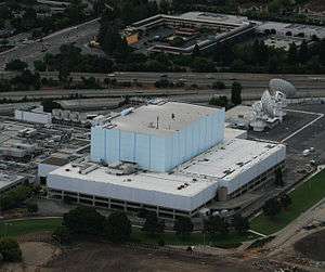
Its distinguishing feature was Building 1003, known locally as the Blue Cube or simply the "Cube" given its size, color, and lack of windows. The station's other distinguishing features were its three primary parabolic dish antennas used for communication with remote tracking stations used to control military satellites; these antennas were named Sun East, Sun West, and Sun 3.
History
In the United States space program's formative stages, Air Force Systems Command contracted with the Philco Ford division of Ford Motor Company to provide interim operational facilities at its Palo Alto, California, location. Operations commenced in the late 1950s. By 1958, the United States Air Force sought a permanent home with larger facilities. Ultimately, the United States Air Force purchased roughly 19 acres of land from Lockheed Corporation, which included Lockheed Building 100, and was named Sunnyvale Air Force Station. Construction of the station's original facilities was completed in 1960. Over time, additional structures were built as operations expanded.
The station was home to the Air Force Systems Command operational unit known as the Air Force Satellite Test Center, colloquially called the "stick," and other non-Air Force Systems Command operational organizations. By 1979, the Air Force Satellite Test Center was renamed the Air Force Satellite Control Facility. On January 26, 1994, Sunnyvale Air Force Station was renamed Onizuka Air Force Station in honor of Lt Col Ellison Onizuka, USAF, one of the astronauts who, on January 28, 1986, died in the Space Shuttle Challenger disaster. Ultimately, both Onizuka Air Force Station and the Air Force Satellite Control Facility were transferred from Air Force Systems Command to Air Force Space Command and was operated by the 21st Space Operations Squadron, a geographically separated unit (GSU) of the 50th Space Wing. The non-Air Force System Command operational organizations remained under their respective commands.
When the station was opened in 1960, the Sunnyvale area was rural and the station was predominantly surrounded by orchards. By the late 1970s, the region had become Silicon Valley and the station's physical security vulnerabilities became apparent. As a result, Air Force Systems Command commenced plans for the Consolidate Space Operations Center (CSOC), which would be located several miles east of Colorado Springs, Colorado at a to be build Falcon Air Force Station (ultimately named Schriever Air Force Base). Spacecraft operations would be split between the two locations and each location would serve as a backup to the other. To maintain this redundancy, when Onizuka Air Force Station was selected for closure by the Base Realignment and Closure Commission, the Air Force determined to relocate Onizuka's remaining operational units to the new Ellison Onizuka Satellite Operations Facility at Vandenberg Air Force Base.[1] Upon completion of this transition, Onizuka Air Force Station was ceremonially closed on July 28, 2010, and officially closed on September 30, 2010.
Closure
Realignment of Onizuka Air Force Station was recommended and accepted as part of the 1995 round of the Base Realignment and Closure Program. In summary, the 750th Space Group was to be inactivated and its functions relocated to Falcon AFB, CO. Detachment 2 of the Space and Missile Systems Center would relocate to Falcon AFB (now Schriever AFB), CO and Kirtland AFB, NM, while some other undisclosed tenants would remain in the existing facilities for some time.[2] On May 13, 2005, Defense Secretary Donald Rumsfeld recommended closing the Onizuka Air Force Station in Sunnyvale as part of a fifth round of military base closures and re-sizing. The date by which the realignment and closure must be completed was September 15, 2011.[3]
In April 2007, the mission of the National Reconnaissance Office at Onizuka AFS ended after 46 years.[4]
On or about April 15, 2014, the site began full-scale demolition, with 9 acres of the land slated for conversion to educational space operated by the Foothill–De Anza Community College District.[5] 4.4 acres of the land will be used by the Department of Veterans Affairs. One acre was added to Sunnyvale's existing Fire Station 5 and is now subject to a land swap with a developer to relocate Fire Station 5, upgrade it to full service capabilities, and support a shooting range for Public Safety personnel training. The remaining 5 acre parcel is now owned by the City of Sunnyvale for an unspecified future use.[6]
References
- ↑
- ↑ "Onizuka Air Station, California". Air Force Real Property Agency. Archived from the original on May 10, 2006. Retrieved May 5, 2006.
- ↑ "Base Realignment and Closure (BRAC) of Onizuka Air Force Station (AFS) Frequently Asked Questions (FAQ)". City of Sunnyvale, California. Retrieved May 8, 2007.
- ↑ "Mission accomplished for NRO at Onizuka AFS". 21st Space Operations Squadron. Retrieved May 8, 2007.
- ↑ "Wrecking crews demolish iconic 'Blue Cube'". San Jose Mercury News. Retrieved April 17, 2014.
- ↑ "Onizuka AFS Land Areas" (PDF). City of Sunnyvale. Retrieved April 21, 2014.
External links
| Wikimedia Commons has media related to Onizuka Air Force Station. |
- Onizuka Air Force Station
- 750th Medical Squadron at Onizuka
- Roster of 750 MDS Staff
- BRAC 2005: Closings, Realignments to Reshape Infrastructure
Air Force Space Command (AFSPC) | |||||||||||||||||||||||||||||||||
|---|---|---|---|---|---|---|---|---|---|---|---|---|---|---|---|---|---|---|---|---|---|---|---|---|---|---|---|---|---|---|---|---|---|
| |||||||||||||||||||||||||||||||||
| |||||||||||||||||||||||||||||||||
| |||||||||||||||||||||||||||||||||
| |||||||||||||||||||||||||||||||||