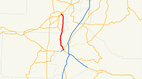
Oregon Route 221
| ||||
|---|---|---|---|---|
 | ||||
| Route information | ||||
| Maintained by ODOT | ||||
| Length: | 20.74 mi (33.38 km) | |||
| Major junctions | ||||
| South end: |
| |||
|
| ||||
| North end: |
| |||
| Highway system | ||||
| ||||

Oregon Route 221 is an Oregon state highway which runs between the city of Salem, Oregon and the city of Dayton, Oregon, roughly along the western shore of the Willamette River. It is known as the Salem-Dayton Highway No. 150 (see Oregon highways and routes), and is 21 miles (34 km) long. It lies in the counties of Yamhill and Polk County.
Route description
OR 221 begins, at its southern terminus, at an interchange with OR 22 in Salem, just west of the Marion Street Bridge. From there it heads northwest, as an urban expressway known locally as Wallace Road; upon leaving the Salem area it becomes a 2-lane country road, which roughly parallels the Willamette River to the east. In some locations, the highway is right on the river's shore; in others it is some distance inland.
The highway continues north, into Yamhill County. It passes near the community of Hopewell and through Dayton, terminating at an interchange with OR 18 and OR 233 just north of Dayton. The last stretch of the highway, in Dayton, runs parallel to the Yamhill River, which empties into the Willamette just east of Dayton.
Intersections with other highways
- OR 22 in Salem
- OR 18 in Dayton
- OR 233 in Dayton