Oregon Route 339
| ||||
|---|---|---|---|---|
 | ||||
| Route information | ||||
| Maintained by ODOT | ||||
| Length: | 3.43 mi[1] (5.52 km) | |||
| Existed: | 2003 – present | |||
| Major junctions | ||||
| South end: | Milton-Freewater city limits | |||
| North end: | State Line Road near Ferndale | |||
| Highway system | ||||
| ||||

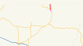
Oregon Route 339 (OR 339) is an Oregon state highway running from the Washington state line near Ferndale to Milton-Freewater. OR 339 is known as the Freewater Highway No. 339 (see Oregon highways and routes). It is 3.43 miles (5.52 km) long and runs north–south, entirely within Umatilla County.
OR 339 was established in 2003 as part of Oregon's project to assign route numbers to highways that previously were not assigned, and, as of July 2010, was unsigned.
Route description
OR 339 begins at an intersection with State Line Road approximately one and one half miles north of Ferndale, at the Washington state line, and heads south through Ferndale and Sunnyside. Approximately one-half-mile south of Sunnyside, OR 339 intersects OR 332. OR 339 ends at the Milton-Freewater northern city limit.
History
OR 339 was assigned to the Freewater Highway in 2003.
Major intersections
The entire route is in Umatilla County.
| Location | mi[1] | km | Destinations | Notes | |
|---|---|---|---|---|---|
| Milton-Freewater | 3.43 | 5.52 | Begin state maintenance | Continues as Lamb Street | |
| Sunnyside | 2.67 | 4.30 | |||
| Oregon–Washington state line | 0.00 | 0.00 | Stateline Road | Continuation into Washington as Old Milton Highway | |
| 1.000 mi = 1.609 km; 1.000 km = 0.621 mi | |||||
References
- 1 2 "Freewater Highway No. 339" (PDF). Oregon Department of Transportation. January 2015. Retrieved February 19, 2016.
- Oregon Department of Transportation, Descriptions of US and Oregon Routes, http://www.oregon.gov/ODOT/HWY/TRAFFIC/TEOS_Publications/PDF/Descriptions_of_US_and_Oregon_Routes.pdf, page 30.