Oval, London

Coordinates: 51°28′53″N 0°07′11″W / 51.4813°N 0.1197°W
Oval is a geographically small area of Kennington, south London, in the London Borough of Lambeth. It is situated 2.1 miles (3.38 km) to the south-east of Charing Cross. Oval straddles the border of south-west London and south-east London, and is where the postcode SE11 converges with the postcodes SW8 and SW9. Oval is best known for The Oval cricket ground, the home-ground of Surrey County Cricket Club.
Oval is within the borough constituency of Vauxhall. The Member of Parliament for the area is Kate Hoey of the Labour Party.
History
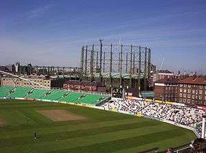
The land here was, from the seventeenth century, used for a market garden. The name "Oval" emerged from a street layout which was originated in 1790 but never completely built. The Montpelier Cricket Club leased ten acres of land from the Duchy of Cornwall in 1844, and Surrey County Cricket Club was formed soon thereafter at a meeting at the Horns Tavern (since demolished) on Kennington Park Road.
Demography
Oval ward is in the Vauxhall parliamentary constituency and is one of four wards in the borough's north Lambeth division. It includes part of Kennington and some of the River Thames. In 2001, the National Census recorded a population of 11,983 for Oval.
Lambeth Council elections 2010
At the Lambeth Council elections, 2010 residents of Oval ward elected two Labour Party Councillors and one Liberal Democrat Councillor.
In the 2014 Lambeth Council election residents returned three Labour Councillors, Cllr Jack Hopkins, Cllr Claire Holland and Cllr Jane Edbrooke.
Transport
The nearest tube stations are Oval and Vauxhall station.
Nearest places
 |
Kennington | | ||
| Vauxhall | |
Brixton | ||
| ||||
| | ||||
| Stockwell |
See also
| Districts |  | |
|---|---|---|
| Attractions |
| |
| Bridges | ||
| Parks and open spaces |
| |
| Constituencies | ||
| Tube, rail and riverboat stations | ||
| Other topics | ||
References
- ↑ "Lambeth Ward population 2011". Neighbourhood Statistics. Office for National Statistics. Retrieved 12 October 2016.
External links
- Lambeth Council profile for the ward
- Lambeth Council map of the ward
- Oval ward results on Lambeth website
- Lib Dem Councillor's blog
- Oval Labour blog
- census information