Pécel
| Pécel | ||
|---|---|---|
|
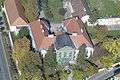
Ráday palace, Pécel | ||
| ||
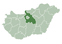
 Pécel Location of Pécel | ||
| Coordinates: 47°29′21″N 19°20′08″E / 47.4893°N 19.33542°ECoordinates: 47°29′21″N 19°20′08″E / 47.4893°N 19.33542°E | ||
| Country |
| |
| County | Pest | |
| Area | ||
| • Total | 43.63 km2 (16.85 sq mi) | |
| Population (2007) | ||
| • Total | 14,328 | |
| • Density | 306.14/km2 (792.9/sq mi) | |
| Time zone | CET (UTC+1) | |
| • Summer (DST) | CEST (UTC+2) | |
| Postal code | 2119 | |
| Area code(s) | 28 | |


Pécel is a town in Pest county, Budapest metropolitan area, Hungary. It is situated outside Budapest's 17th district a little over 20 kilometres (12 miles) from Budapest city centre.
Notable Residents
- Gedeon Ráday, Hungarian soldier and politician, Minister of Defence
- István Sárközi, Hungarian footballer, won a gold medal in the 1968 Olympic team competition
Twin towns — Sister cities
Pécel is twinned with:
-
 Mistelbach, Austria
 -
 Iisalmi, Finland
Gallery


External links
This article is issued from Wikipedia - version of the 2/27/2016. The text is available under the Creative Commons Attribution/Share Alike but additional terms may apply for the media files.