Přeštice
| Přeštice | ||
| Town | ||
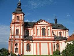 Church of the Assumption | ||
|
||
| Country | Czech Republic | |
|---|---|---|
| Region | Plzeň | |
| District | Plzeň-South | |
| Commune | Přeštice | |
| Center | Masarykovo náměstí | |
| - elevation | 345 m (1,132 ft) | |
| - coordinates | 49°34′21.18″N 13°19′43.87″E / 49.5725500°N 13.3288528°ECoordinates: 49°34′21.18″N 13°19′43.87″E / 49.5725500°N 13.3288528°E | |
| Area | 25.39 km2 (9.80 sq mi) | |
| Population | 6,681 (2006-07-03) | |
| Density | 263/km2 (681/sq mi) | |
| First mentioned | 1226 | |
| Mayor | Karel Naxera | |
| Timezone | CET (UTC+1) | |
| - summer (DST) | CEST (UTC+2) | |
| Postal code | 334 01 | |
  Location in the Czech Republic | ||
| Wikimedia Commons: Přeštice | ||
| Statistics: statnisprava.cz | ||
| Website: www.prestice-mesto.cz | ||
Přeštice (Czech pronunciation: [ˈpr̝̊ɛʃcɪtsɛ]; German: Prestitz) is a town in the Plzeň Region of the Czech Republic. It lies on the Úhlava River, some 20 km (12 mi) to the south from the region capital of Pilsen.
Přeštice is also the seat of the Municipality with Extended Competence and Municipality with Commissioned Local Authority within the same borders.
History
Until 1918, PRESTITZ - PŘEŠTICE (previously PRZESTITZ or PRESTIC[1]) was part of the Austrian monarchy (Austria side after the compromise of 1867), in the district of the same name, one of the 94 Bezirkshauptmannschaften in Bohemia.[2]
References
External links
 Media related to Přeštice at Wikimedia Commons
This article is issued from Wikipedia - version of the 10/8/2016. The text is available under the Creative Commons Attribution/Share Alike but additional terms may apply for the media files.