P'iq'iñ Q'ara (La Paz)
This article is about the mountain in the Palca Municipality, Murillo Province, La Paz Department, Bolivia. For other uses, see P'iqi Q'ara.
| P'iq'iñ Q'ara | |
|---|---|
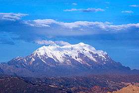 Illimani with P'iq'iñ Q'ara in front of it (on the left) as seen from the north-west | |
| Highest point | |
| Elevation | 5,059 m (16,598 ft) [1] |
| Coordinates | 16°36′42″S 67°49′26″W / 16.61167°S 67.82389°WCoordinates: 16°36′42″S 67°49′26″W / 16.61167°S 67.82389°W |
| Geography | |
 P'iq'iñ Q'ara Location within Bolivia | |
| Location |
Bolivia, La Paz Department, Murillo Province |
| Parent range | Andes, Cordillera Real |
P'iq'iñ Q'ara (Aymara p'iq'iña head, q'ara bare, bald, p'iq'iña q'ara bald,[2] "baldheaded", also spelled Phekhen Khara) is a 5,059-metre (16,598 ft) high mountain in the Cordillera Real in the Andes of Bolivia. It is situated in the La Paz Department, Murillo Province, Palca Municipality. P'iq'iñ Q'ara lies southwest of the mountain Pupusani, west to northwest of Ch'iyar Qullu and northwest of Illimani.[1][3]
References
- 1 2 Bolivian IGM map 1:50,000 Palca 6044-III
- ↑ Radio San Gabriel, "Instituto Radiofonico de Promoción Aymara" (IRPA) 1993, Republicado por Instituto de las Lenguas y Literaturas Andinas-Amazónicas (ILLLA-A) 2011, Transcripción del Vocabulario de la Lengua Aymara, P. Ludovico Bertonio 1612 (Spanish-Aymara-Aymara-Spanish dictionary) see: Cabeza del hombre y de todos los animales and Calvo
- ↑ "Irupana". INE, Bolivia. Retrieved October 31, 2014. (unnamed)
This article is issued from Wikipedia - version of the 2/13/2016. The text is available under the Creative Commons Attribution/Share Alike but additional terms may apply for the media files.