Palisades (California Sierra)
| The Palisades | |
|---|---|
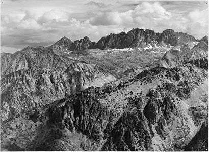 North Palisade from Windy Point (by Ansel Adams, 1936) | |
| Highest point | |
| Peak | North Palisade |
| Elevation | 14,248 ft (4,343 m) NAVD 88[1] |
| Coordinates | 37°05′39″N 118°30′52″W / 37.094260386°N 118.514455033°WCoordinates: 37°05′39″N 118°30′52″W / 37.094260386°N 118.514455033°W [2] |
| Dimensions | |
| Length | 30 mi (48 km) North-South |
| Width | 21 mi (34 km) East-West |
| Geography | |
| Country | United States |
| State | California |
| Counties | Fresno and Inyo |
.jpg)
The Palisades (or the Palisade Group) are a group of peaks in the central part of the Sierra Nevada in the U.S. state of California. They are located about 12 miles (19 km) southwest of the town of Big Pine, California. The peaks in the group are particularly steep, rugged peaks and "contain the finest alpine climbing in California."[3] The group makes up about 6 miles (10 km) of the Sierra Crest, which divides the Central Valley watershed from the Owens Valley, and which runs generally northwest to southeast.
Josiah Whitney in his book Geology, Volume 1 writes:
"At the head of the north fork, along the main crest of the Sierra, is a range of peaks, from 13,500 to 14,000 feet high, which we called 'the Palisades.' These were unlike the rest of the crest in outline and color, and were doubtless volcanic; they were very grand and fantastic in shape."[4]
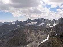
On the northeast side of the group lie the Palisade Glacier and the Middle Palisade Glacier, the largest glaciers in the Sierra Nevada. These glaciers feed Big Pine Creek.
Notable peaks of the group include four independent[5] fourteeners:
- North Palisade, 14,248 ft (4,343 m)[1]
- Mount Sill, 14,159 ft (4,316 m)[6]
- Split Mountain, 14,064 ft (4,287 m)[7]
- Middle Palisade, 14,018 ft (4,273 m)[8]
and the following mountains in addition:
- Mount Agassiz, 13,899 ft (4,236 m),[9] the northwesternmost peak of the group before Bishop Pass.
- Birch Mountain, 13,608 ft (4,148 m),[10] which juts out further towards the Owens Valley than the rest of the group.
- Norman Clyde Peak, 13,861 ft (4,225 m)[11]
- Palisade Crest, 13,559 ft (4,133 m)[12]
- Temple Crag, 12,982 ft (3,957 m),[13] known for its many rock climbing routes.
- Mount Winchell, 13,781 ft (4,200 m)[14]
North Palisade has some additional subpeaks over 14,000 feet (4,267 m); see the North Palisade article for those summits.
References
- 1 2 "North Palisade". Peakbagger.com. Retrieved 2011-03-30.
- ↑ "North Palisade". NGS data sheet. U.S. National Geodetic Survey. Retrieved 2009-12-11.
- ↑ Roper, Steve (1976). The Climber's Guide to the High Sierra. San Francisco: Sierra Club Books. p. 187. ISBN 9780871561473.
- ↑ Whitney, Josiah (1885). Geology, Volume 1. OCLC 4167195.
- ↑ This uses a topographic prominence cutoff of 300 feet (91 m). See the fourteener article for more information.
- ↑ "Mount Sill, California". Peakbagger.com. Retrieved 2014-01-20.
- ↑ "Split Mountain, California". Peakbagger.com. Retrieved 2014-01-20.
- ↑ "Middle Palisade, California". Peakbagger.com. Retrieved 2014-01-20.
- ↑ "Mount Agassiz, California". Peakbagger.com. Retrieved 2014-01-20.
- ↑ "Birch Mountain". Peakbagger.com. Retrieved 2008-12-28.
- ↑ "Norman Clyde Peak, California". Peakbagger.com. Retrieved 2014-01-20.
- ↑ "Palisade Crest". Peakbagger.com. Retrieved 2008-12-28.
- ↑ "Temple Crag". Peakbagger.com. Retrieved 2008-12-28.
- ↑ "Mount Winchell". Peakbagger.com. Retrieved 2008-12-28.
External links
- "Palisades". SummitPost.org.
| Wikimedia Commons has media related to The Palisades. |