Palo Cedro, California
| Palo Cedro | |
|---|---|
| census-designated place | |
|
Windmill, Downtown Palo Cedro | |
 Location in Shasta County and the state of California | |
| Coordinates: 40°33′4″N 122°14′3″W / 40.55111°N 122.23417°WCoordinates: 40°33′4″N 122°14′3″W / 40.55111°N 122.23417°W | |
| Country |
|
| State |
|
| County | Shasta |
| Area[1] | |
| • Total | 3.754 sq mi (9.722 km2) |
| • Land | 3.679 sq mi (9.528 km2) |
| • Water | 0.075 sq mi (0.194 km2) 2.00% |
| Elevation | 465 ft (143 m) |
| Population (2010) | |
| • Total | 1,269 |
| • Density | 340/sq mi (130/km2) |
| Time zone | Pacific (PST) (UTC-8) |
| • Summer (DST) | PDT (UTC-7) |
| ZIP code | 96073 |
| Area code(s) | 530 |
| FIPS code | 06-55296 |
| GNIS feature ID | 0230275 |
Palo Cedro is a census-designated place (CDP) in Shasta County, California, United States. The population was 1,269 at the 2010 census, up from 1,247 at the 2000 census. It is 8 miles (13 km) east of Redding, California. The communities of Bella Vista (pop. 2,781), Millville (pop. 727), Shingletown (pop. 2,283), Oak Run (pop. 760), Whitmore (pop. 593), and Round Mountain (pop. 155) lie within a fifteen-mile (24 km) radius.
History
The earliest history of Palo Cedro comes from the diary of American fur trader John Work (c.1792-1861). In 1832 he reported traveling in with a group from the Hudson Bay Company Fur Traders along Cow Creek through the area now known as Palo Cedro.
In 1883, a United States post office was established for this area; at that time, the town was known as Albertson. The name was changed to Roberts in 1885 and finally to Palo Cedro in 1893, the Spanish term for the cedarwood tree of the area.
In the early 1890s, T.W.H. Shannahan and Joe Enright bought 30 acres (120,000 m2) of land from Lem Benton and had it divided into 12 lots. They did not develop a town but the cedarwood tree for which it was named Palo Cedro was cut down.
In 1897, or shortly before, the Anderson and Bella Vista Railroad was constructed by the Terry Lumber Company from Anderson to Bella Vista, passing through Palo Cedro. Miners used this railroad, as did the Terry Lumber Company at Bella Vista. The train delivered groceries and mail to the villages along its route. It also had a passenger car.
In the early 1900s, the stage route went from Redding through Palo Cedro, Millville, Oak Run, and on to Fall River Mills.
Palo Cedro's first school house was located near the corner of Hillside Drive and Deschutes Road on the south side of town. Later it was moved to a site near the Grange Hall, on the north side of town. The school was located there until the "new" Junction School was built in 1960 on the south side of town.
In 1907 or thereabouts, Frank and Mary Love owned the Palo Cedro general store. The store was on the west side of the tracks and their house on the east. A two-story house on the northeast corner of Deschutes Road and Old Forty-Four Drive may, at one time, have been a stopping place for stage drivers and travelers. Sarah Addington later owned the Palo Cedro store. She was also the postmaster and handed the position down to her daughter, Mary Jones. She moved the post office next door into her home.
John Gebauer has since owned the store. In the 1960s John moved to his new building on the south east side of Palo Cedro; it had several one-story spaces for commercial businesses. The largest business was the Palo Cedro Market. Gebauer's son John now operates it. The post office moved into a part of Gebauer's building. Mary Jones' assistants were her sisters. The next postmaster was Sylvia Metz. As she found the post office needed more space, it moved to a two-story building on the north side of Palo Cedro.
The first Grange Hall and Feed Store were constructed in the early 1930s just off Deschutes Road on Old Highway 44. The building was two stories with the meeting and/or dance hall upstairs. The dining room was downstairs in back and the feed store in front. This building burned down in the early 1940s and was quickly replaced with a one story building, which is still in use in the 21st century. The feed store was built on the north side of Old Forty-Four Drive and is still there today.
As Palo Cedro continued to grow more services were needed, and the first independently owned pharmacy opened in August 1975. Its first space was a remodelled auto body shop. To accommodate its growing business, it moved to the current location on the south side of Highway 44 off Deschutes Road. Palo Cedro Pharmacy has an eclectic mix of pictures, memorabilia, and antiques collected over the last 40 years showing how the town and pharmacy has changed over the years. The current mayor of Palo Cedro is Max Jenkins.
Geography
Palo Cedro is located at 40°33′4″N 122°14′3″W / 40.55111°N 122.23417°W (40.551091, -122.234255).[2]
According to the United States Census Bureau, the CDP has a total area of 3.8 square miles (9.8 km2), 98.00% of it land, and 2.00% of it water.
Climate
According to the Köppen Climate Classification system, Palo Cedro has a warm-summer Mediterranean climate, abbreviated "Csa" on climate maps.[3]
Demographics
2010
The 2010 United States Census[4] reported that Palo Cedro had a population of 1,269. The population density was 338.1 people per square mile (130.5/km²). The racial makeup of Palo Cedro was 1,164 (91.7%) White, 7 (0.6%) African American, 24 (1.9%) Native American, 6 (0.5%) Asian, 1 (0.1%) Pacific Islander, 22 (1.7%) from other races, and 45 (3.5%) from two or more races. Hispanic or Latino of any race were 74 persons (5.8%).
The Census reported that 1,260 people (99.3% of the population) lived in households, 4 (0.3%) lived in non-institutionalized group quarters, and 5 (0.4%) were institutionalized.
There were 474 households, out of which 153 (32.3%) had children under the age of 18 living in them, 318 (67.1%) were opposite-sex married couples living together, 41 (8.6%) had a female householder with no husband present, 24 (5.1%) had a male householder with no wife present. There were 18 (3.8%) unmarried opposite-sex partnerships, and 7 (1.5%) same-sex married couples or partnerships. 70 households (14.8%) were made up of individuals and 38 (8.0%) had someone living alone who was 65 years of age or older. The average household size was 2.66. There were 383 families (80.8% of all households); the average family size was 2.89.
The population was spread out with 289 people (22.8%) under the age of 18, 74 people (5.8%) aged 18 to 24, 192 people (15.1%) aged 25 to 44, 429 people (33.8%) aged 45 to 64, and 285 people (22.5%) who were 65 years of age or older. The median age was 48.3 years. For every 100 females there were 96.4 males. For every 100 females age 18 and over, there were 95.6 males.
There were 504 housing units at an average density of 134.3 per square mile (51.8/km²), of which 411 (86.7%) were owner-occupied, and 63 (13.3%) were occupied by renters. The homeowner vacancy rate was 1.9%; the rental vacancy rate was 7.2%. 1,072 people (84.5% of the population) lived in owner-occupied housing units and 188 people (14.8%) lived in rental housing units.
2000
As of the census[5] of 2000, there were 1,247 people, 436 households, and 367 families residing in the CDP. The population density was 330.1 people per square mile (127.4/km²). There were 447 housing units at an average density of 118.3 per square mile (45.7/km²). The racial makeup of the CDP was 93.10% White, 0.56% African American, 1.12% Native American, 1.52% Asian, 0.88% from other races, and 2.81% from two or more races. Hispanic or Latino of any race were 2.57% of the population.
There were 436 households out of which 37.6% had children under the age of 18 living with them, 74.5% were married couples living together, 7.8% had a female householder with no husband present, and 15.6% were non-families. 13.3% of all households were made up of individuals and 5.3% had someone living alone who was 65 years of age or older. The average household size was 2.85 and the average family size was 3.12.
In the CDP the population was spread out with 27.7% under the age of 18, 6.7% from 18 to 24, 22.7% from 25 to 44, 28.7% from 45 to 64, and 14.2% who were 65 years of age or older. The median age was 41 years. For every 100 females there were 95.8 males. For every 100 females age 18 and over, there were 94.8 males.
The median income for a household in the CDP was $51,471, and the median income for a family was $60,385. Males had a median income of $47,232 versus $33,125 for females. The per capita income for the CDP was $23,419. About 5.4% of families and 5.5% of the population were below the poverty line, including 14.1% of those under age 18 and none of those age 65 or over.
Politics
In the state legislature Palo Cedro is located in the 1st Senate District, represented by Republican Ted Gaines,[6] and the 1st Assembly District, represented by Republican Brian Dahle.[7]
Federally, Palo Cedro is in California's 1st congressional district, represented by Republican Doug LaMalfa.[8]
Notable People
- Merle Haggard, country musician, lived in Palo Cedro for decades until his death on this 79th birthday (April 6, 2016)
Education
- Elementary Schools:
- North Cow Creek School
- Junction Elementary School
- Chrysalis Charter School
- Middle Schools
- Junction Intermediate School
- Saint Francis Middle School
- Chrysalis Charter School
- North Cow Creek School
- High Schools
- Foothill High School has an API score of 817, making it one of the best public schools in northern California.
- Bishop Quinn High School
Image gallery
 View from Palo Cedro of Sunrise over Mount Lassen (September 2007)
 Windmill landmark in Palo Cedro shopping center (November 2007)
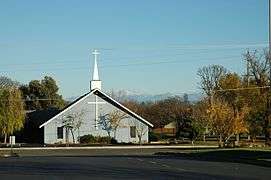 Local Church with Mount Lassen in the Background (November 2007)
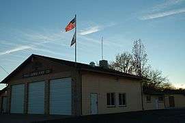 Palo Cedro Fire Department (November 2007)
 Junction Middle School (Thanksgiving Holiday 2007)
 Foothill High School (November 2007)
 Deschutes Road Looking North, From Junction Elementary School (September 2007)
 Palo Cedro' Church of Jesus Christ of Latter-day Saints (November 2007)
 The Palo Cedro Inn—A Palo Cedro Landmark (November 2007)
References
- ↑ U.S. Census
- ↑ "US Gazetteer files: 2010, 2000, and 1990". United States Census Bureau. 2011-02-12. Retrieved 2011-04-23.
- ↑ Climate Summary for Palo Cedro, California
- ↑ "2010 Census Interactive Population Search: CA - Palo Cedro CDP". U.S. Census Bureau. Retrieved July 12, 2014.
- ↑ "American FactFinder". United States Census Bureau. Retrieved 2008-01-31.
- ↑ "Senators". State of California. Retrieved March 10, 2013.
- ↑ "Members Assembly". State of California. Retrieved March 2, 2013.
- ↑ "California's 1st Congressional District - Representatives & District Map". Civic Impulse, LLC. Retrieved March 1, 2013.
External links
- Palo Cedro Community Park Project
- Palo Cedro Chamber of Commerce
- Foothill High School
- Junction Elementary School District
- Palo Cedro News
- Palo Cedro Real Estate and area information
Municipalities and communities of Shasta County, California, United States | ||
|---|---|---|
| Cities | 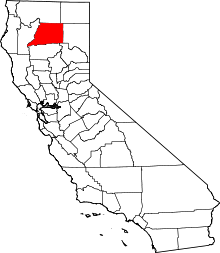 | |
| CDPs | ||
| Unincorporated communities |
| |
| Indian reservations | ||
| Ghost town |
| |