Palumani
| Palumani | |
|---|---|
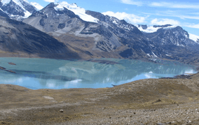 The southern slope of Palumani (on the left) behind Such'i Lake as seen from the southeast | |
| Highest point | |
| Elevation | 5,723[1] m (18,776 ft) |
| Coordinates | 14°43′03″S 69°14′31″W / 14.71750°S 69.24194°WCoordinates: 14°43′03″S 69°14′31″W / 14.71750°S 69.24194°W |
| Geography | |
 Palumani Location in Bolivia, on the border with Peru | |
| Location | Bolivia–Peru border |
| Parent range | Andes, Apolobamba |
Palumani (Aymara, urpi, paluma dove,[2][3] "the one with a dove (or doves)", also spelled Palomani) is a mountain in the Apolobamba mountain range on the border of Bolivia and Peru. It reaches a height of about 5,723 metres (18,776 ft). On the Bolivian side it is located in the La Paz Department, Franz Tamayo Province, Pelechuco Municipality, and on the Peruvian side it lies in the Puno Region, Putina Province, Ananea District. It is situated north of Such'i Lake. Palumani is south of Chawpi Urqu (or Wisk'achani), Salluyu and Jichu Qullu, near Ch'uxñaquta in the west.[4][5]
References
- ↑ John Biggar, The Andes: A Guide for Climbers, p. 126
- ↑ Radio San Gabriel, "Instituto Radiofonico de Promoción Aymara" (IRPA) 1993, Republicado por Instituto de las Lenguas y Literaturas Andinas-Amazónicas (ILLLA-A) 2011, Transcripción del Vocabulario de la Lengua Aymara, P. Ludovico Bertonio 1612 (Spanish-Aymara-Aymara-Spanish dictionary)
- ↑ Guillermo Cutipa Añamuro, Chacra qarpaña: Regando la chacra, IECTA, Iquique - Chile 2005, p. 27
- ↑ "Pelechuco". ine.gob.bo. Retrieved December 15, 2014.
- ↑ escale.minedu.gob.pe - UGEL map of the Putina Province (Puno Region)

This article is issued from Wikipedia - version of the 12/6/2015. The text is available under the Creative Commons Attribution/Share Alike but additional terms may apply for the media files.