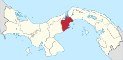
Panamá Oeste Province
| Panamá Oeste Province Provincia de Panamá Oeste | ||
|---|---|---|
| Province | ||
| ||
 Location of Panama Oeste Province in Panama | ||
| Coordinates: 8°52′49″N 79°47′0″W / 8.88028°N 79.78333°WCoordinates: 8°52′49″N 79°47′0″W / 8.88028°N 79.78333°W | ||
| Country | Panama | |
| Created | 1 January 2014 | |
| Capital city | La Chorrera | |
| Government | ||
| • Governor | Temístocles Javier Herrera[1] | |
| Area | ||
| • Total | 2,786 km2 (1,076 sq mi) | |
| Population (2010 census) | ||
| • Total | 464,038 | |
| • Density | 170/km2 (430/sq mi) | |
| Time zone | Eastern Time (UTC-5) | |
| ISO 3166 code | PA-10 | |
Panamá Oeste (Spanish pronunciation: [panaˈma oˈeste]; "West Panama" in English) is the newest province in Panama.
It was created from the five districts of Panamá Province west of the Panama Canal on 1 January 2014.[2] The capital is La Chorrera.
References
- ↑ Ministro Henríquez juramenta al nuevo Gobernador de la Décima Provincia "Ministro Henríquez juramenta al nuevo Gobernador de la Décima Provincia" Check
|url=value (help). Government of Panama. 15 July 2014. Retrieved 13 June 2015. - ↑ Gaceta Oficial de Panamá (30 December 2013). "Ley Nº119 del 30 de diciembre de 2013: Que crea la provincia de Panamá Oeste, segregada de la provincia de Panamá." (PDF).
This article is issued from Wikipedia - version of the 9/7/2016. The text is available under the Creative Commons Attribution/Share Alike but additional terms may apply for the media files.
