Pando Department
| Pando Department Departamento de Pando | ||
|---|---|---|
|
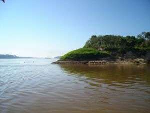
On the border between Brazil and Bolivia. The Madeira River is on the left, the Abunã River on the right. | ||
| ||
|
Motto: "Trabajo Industria Progreso" "Work, Industry, Progress" Anthem: Tierra santa, vestida de gloria Holy land, dressed in glory | ||
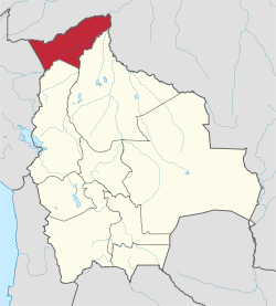 Pando Department (red) within Bolivia. | ||
| Established | September 24, 1938 | |
| Named for | José Manuel Pando | |
| Capital | Cobijaa | |
| Provinces | 5 | |
| Government | ||
| • Prefect | Rafael Bandeira (interim) | |
| • Senators |
Manuel Limachi Quispe (MAS) Mirtha Da Costa Ferreira (MAS) Roger Pinto Molina (PPB) Carmen E. Gonzales Lafuente (PPB) | |
| • Deputies | 5 of 130 | |
| Area | ||
| • Total | 63,827 km2 (24,644 sq mi) | |
| Area rank | 5th in Bolivia | |
| 5.82% of Bolivia | ||
| Population (2012 census) | ||
| • Total | 110,436 | |
| • Density | 1.7/km2 (4.5/sq mi) | |
| • % of Bolivia | 0.7 | |
| • Rank | 9th in Bolivia | |
| Time zone | UTC-4 | |
| Area code(s) | +(591) 3 | |
| ISO 3166 code | BO-N | |
| Official language | Spanish | |
| Abbreviations | PA | |
| Website |
www | |
| a. Also largest city. | ||

Pando is a department of Bolivia, with an area of 63,827 square kilometres (24,644 sq mi), adjoining the border with Brazil and Perú. Pando has a population 110,436 (2012 census). Its capital is the city of Cobija.
The department, which is named after former president José Manuel Pando (1899–1905), is divided into five provinces.
Although Pando is rich in natural resources, the poverty level of its inhabitants is high, due largely to the lack of roads effectively linking the province to the rest of the country and the presence of tropical diseases, typical of life in the Amazonian rain forest. The main economic activities are agriculture, timber and cattle.
At an altitude of 280 metres above sea level in the northwestern jungle region, Pando is located in the rainiest part of Bolivia. Pando also has a hot climate, with temperatures commonly above 26 degrees Celsius (80 Fahrenheit).
Pando is the least populous department in Bolivia, the most tropical (lying closest to the Equator in the Amazonian Basin), and the most isolated, due to an absence of effective roads linking it to the rest of the country. It was organized at the beginning of the 20th century from what was left of the Acre Territory, lost to Brazil as a result of the so-called Acre War (1903). Its capital city of Cobija (the smallest of all the Bolivian departmental capitals) was named after the much-lamented Bolivian port of the same name on the Pacific Ocean, part of an area lost to Chile following the War of the Pacific.
Although backward and remote, Pando is densely forested and close to navigable waterways leading to the Amazon River and from there on to the Atlantic Ocean. The department underwent a rubber boom in the late 19th century and early 20th century, along with the northern part of nearby Beni department. The "boom," however, turned into a collapse of the rubber industry when synthetic rubber was discovered.
Culturally, the Pandinos are considered part of the so-called Camba culture of the Bolivian lowlands, similar to the people of the country's other two tropical departments, Beni and Santa Cruz. Many of Pando's original settlers moved from nearby Beni.
Autonomy movement
Far from the centers of power in Bolivian society, Pando has recently linked its fate with that of Santa Cruz and Beni, which (along with Tarija and Chuquisaca) are demanding increased autonomy for the departments at the expense of the central government. The government of Leopoldo Fernández strongly backed autonomy for the department, in alliance with other governors of the eastern media luna (half-moon, so known for their combined geographic shape). Nationwide referenda on autonomy held on July 2, 2006, were approved in all four departments. A second referendum to approve a statute of autonomy was held by each department in mid-2008, despite being declared illegal by the National Electoral Court in March. Left-wing and pro-Morales social movements boycotted the votes.[1] Pando's referendum, held on June 1, 2008, won 82% approval among those who voted, but 46.5% of the registered electorate did vote, the highest abstention rate in the four departments holding such referenda.[2] Considerable social unrest took place in 2008, culminating with the spectacular arrest in September 2008 of Prefect Leopoldo Fernández, stemming from the massacre at El Porvenir[3] of anti-autonomy backers of President Evo Morales.
Provinces of Pando
Languages
The predominant language in the department is Spanish. The following table shows the number of those belonging to the recognized group of speakers.[4]
| Language | Department | Bolivia |
|---|---|---|
| Quechua | 1,708 | 2,281,198 |
| Aymara | 1,848 | 1,525,321 |
| Guaraní | 35 | 62,575 |
| Another native | 861 | 49,432 |
| Spanish | 45,969 | 6,821,626 |
| Foreign | 7,719 | 250,754 |
| Only native | 336 | 960,491 |
| Native and Spanish | 3,676 | 2,739,407 |
| Spanish and foreign | 44,491 | 4,115,751 |
Places of interest
References
- ↑ "Illegal autonomy referendum deepens division in Bolivia". Andean Information Network. April 17, 2008.
- ↑ Two more Bolivian provinces favour more autonomy, Monsters & Critics, 2 June 2008.
- ↑ Chavez, Franz (2008-09-16). "Governor Arrested for "Porvenir Massacre"". Inter Press Service. Retrieved 2009-01-27.
- ↑ obd.descentralizacion.gov.bo (Spanish)
External links
- Pando Travel Guide
- Weather in Pando
- Pando Official website
- Bolivia 9/11: Bodies and Power on a Feudal Frontier by Bret Gustafson, July 14, 2009
- Full information of Pando Department
Coordinates: 11°11′S 67°11′W / 11.183°S 67.183°W