Potosí Department
| Department of Potosí | |||
|---|---|---|---|
| |||
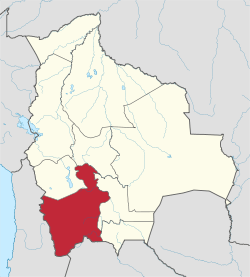 Location within Bolivia | |||
| Coordinates: 20°40′0″S 66°40′0″W / 20.66667°S 66.66667°W | |||
| Country |
| ||
| Capital | Potosí | ||
| Government | |||
| • Governor | Félix Gonzales Bernal | ||
| Area | |||
| • Total | 118,218 km2 (45,644 sq mi) | ||
| Population (2012) | |||
| • Total | 823,517 | ||
| • Density | 7.0/km2 (18/sq mi) | ||
| Time zone | BOT (UTC-4) | ||
| HDI (2004) | - | ||

Potosí Department is a department in southwestern Bolivia. It comprises 118,218 km² with 823,517 inhabitants (2012 census). The capital is the city of Potosí. It is mostly a barren, mountainous region with one large plateau to the west, where the largest salt flat in the world, Salar de Uyuni, is located.
Potosí was the richest province in the Spanish empire, providing a great percentage of the silver that was shipped to Europe.
Potosi is also the location of the San Cristóbal silver, zinc and lead mines, developed by the US-company Apex Silver Mines Limited of Colorado and in November 2008 sold to the Japanese Sumitomo Corporation.
Government
The chief executive office of Bolivia departments (since May 2010) is the governor; until then, the office was called the prefect, and until 2006 the prefect was appointed by the President of Bolivia. The current governor, Esteban Urquizu Cuéllar of the Movement for Socialism – Political Instrument for the Sovereignty of the Peoples was elected on 4 April 2010.
| Date Began | Date Ended | Prefect/Governor | Party | Notes |
|---|---|---|---|---|
| 23 Jan 2006 | 30 May 2010 | Mario Virreira Iporre | MAS-IPSP | First elected prefect. Elected in Bolivian general election, December 2005 |
| 30 May 2010 | 31 May 2015 | Félix Gonzáles | MAS-IPSP | Elected in regional election on 4 April with 63.1% of the vote; first governor |
| 30 May 2010 | 31 May 2015 | Juan Carlos Cejas | MAS-IPSP | Elected in regional election on 29 March. |
| Source: worldstatesmen.org | ||||
Legislative Assembly
Under the 2009 Constitution, each Bolivian department has an elected Departmental Legislative Assembly. The first elections were held 4 April 2010.
Provinces of Potosi Department
The department is divided into 16 provinces which are further supbdivided into 40 municipalities [1] (municipios) and 219 cantons (cantones).
| Province | Capital | Area km² | Population (2012 census) |
Map Number | 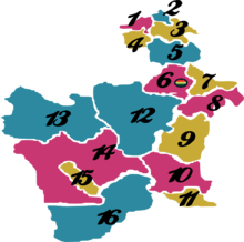 |
|---|---|---|---|---|---|
| Alonso de Ibáñez | Sacaca | 2.170 | 29.821 | 1 | |
| Antonio Quijarro | Uyuni | 14,890 | 54,947 | 12 | |
| Bernardino Bilbao | Arampampa | 640 | 10,224 | 2 | |
| Charcas | San Pedro de Buena Vista | 2,964 | 41,214 | 3 | |
| Chayanta | Colquechaca | 7,026 | 97,251 | 5 | |
| Cornelio Saavedra | Betanzos | 2,375 | 55,100 | 7 | |
| Daniel Campos | Llica | 12,106 | 5,850 | 13 | |
| Enrique Baldivieso | San Agustín | 2,254 | 1,684 | 15 | |
| José María Linares | Puna | 5,136 | 49,619 | 8 | |
| Modesto Omiste | Villazón | 2,260 | 44,645 | 11 | |
| Nor Chichas | Cotagaita | 8,979 | 42,248 | 9 | |
| Nor Lípez | Colcha | 20,892 | 14,057 | 14 | |
| Rafael Bustillo | Uncía | 2,235 | 86,947 | 4 | |
| Sud Chichas | Tupiza | 8,516 | 55,879 | 10 | |
| Sud Lípez | San Pablo de Lípez | 22,355 | 6,835 | 16 | |
| Tomás Frías | Potosí | 3,420 | 229,047 | 6 |
Languages
The languages spoken in the department are mainly Quechua, Spanish and Aymara. The following table shows the number of those belonging to the recognized group of speakers. [2]
| Language | Department | Bolivia |
|---|---|---|
| Quechua | 514,421 | 2,281,198 |
| Aymara | 57,738 | 1,525,321 |
| Guaraní | 374 | 62,575 |
| Another native | 356 | 49,432 |
| Spanish | 438,204 | 6,821,626 |
| Foreign | 3,771 | 250,754 |
| Only native | 226,967 | 960,491 |
| Native and Spanish | 301,280 | 2,739,407 |
| Spanish and foreign | 136,980 | 4,115,751 |
Places of interest
- Eduardo Avaroa Andean Fauna National Reserve
- Torotoro National Park
- Laguna Colorada
- Laguna Verde
- Laguna Blanca
- Salar de Uyuni
- Potosí
- Uyuni
Notable people
- Juana Azurduy de Padilla, guerrilla military leader.
- Manuel Ascencio Padilla, namesake of the town of Padilla, Bolivia.
- Modesto Omiste Tinajeros, writer, politician, and namesake of the province Modesto Omiste.
See also
References
- ↑ www.bolivia.com (English)
- ↑ obd.descentralizacion.gov.bo (Spanish)
External links
- Potosi Travel Guide
- Weather in Potosi
- Bolivian Music and Web Varieties
- Full information of Potosi Department
Capital: Potosí | ||
| Provinces | 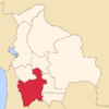 | |
| Municipalities (and seats) |
| |
Coordinates: 20°40′S 66°40′W / 20.667°S 66.667°W