Pangkor Island
| Native name: <span class="nickname" ">Pulau Pangkor ڤولاو ڤڠكور | |
|---|---|
|
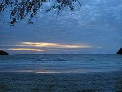
Sunset at a beach of Pangkor | |
 Pangkor | |
| Geography | |
| Location | Strait of Malacca |
| Coordinates | 4°13′12″N 100°33′18″E / 4.22000°N 100.55500°E |
| Area | 18 km2 (6.9 sq mi) |
| Administration | |
| State | Perak |
| District | Manjung |
| Demographics | |
| Population | 25,000 |
Pangkor Island (Malay: Pulau Pangkor) is a resort island in Manjung District, Perak, Malaysia. It has a population of approximately 25,000. Nearby islands include Pangkor Laut Island, Talang Island,[1] Giam Island (Pulau Giam) and Mentagor Island (Pulau Mentagor). The major industries of the island are tourism and fishing.
Geography
Pangkor Island has a land area of 18km2[2] and is 3.5 kilometres (2.2 mi) from Peninsular Malaysia. The interior of the island is forested and is home to 65 reptile species, 17 amphibian species, and 82 total herpetofaunal species.[2]
History
Historically, Pangkor was a refuge for local fishermen, merchants and pirates. In the 17th century, the Dutch built a fort in an effort to control the Perak tin trade known as the Dutch Fort. In 1874, it was the location of a historical treaty between the British government and a contender for the Perak throne (the Pangkor Treaty), which began the British colonial domination of the Malay Peninsula. The old British name for the Pangkor Island group was the Dindings.[3]
In 2003, Marina Island (a man-made island) was developed by the Marina Island Group of companies and began operation in 2010, with private investment of RM250 million by 2013. The integrated mixed development resort island consists of waterfront residential properties, a new jetty called Marina Island Jetty, a private commercial marina called Pangkor Marina Malaysia, service apartments, hotels and shop offices.
2004-2014 was a period of high growth and development for the island and the surrounding district.[4] In 2006, a biotechnology centre, a joint venture of Global Hi-Q Malaysia S/B and Hi-Q Bio-Tech International (Taiwan) Ltd began operations with initial investments of RM100million (USD30m). Their operations include fish farming and aquaculture, and the first harvest was expected in 2009.
Transport
Road
Pangkor Island is a three-hour drive from Kuala Lumpur[5] and is accessible through the Simpang Pulai–Lumut 4-lane dual carriage highway and the West Coast Expressway. Buses arrive frequently at the main jetties in Lumut. There are no bridges connecting the island to the mainland because there exists a policy to control the number of vehicles on the island to prevent road congestion.
There are no public bus services to the Marina.
Ferry
Public ferries depart from Lumut to Pangkor Island from the old Lumut jetty, the nearby Lumut waterfront, the Lumut bus terminal, and the multi-storey car park. T ferry start from 7.00am till 8.30pm, about every2 0 minutes, (RM10 return ticket.)
There are two stops in Pangkor Island, both stops are at the east side of Pangkor Island. The first stop is at Sungai Pinang, SPK jetty. Its mainly for local residents, fishingpeople and guests for some guesthouses and homestay tourists. The second stop is at Pangkor Town Jetty, where shops and government buildings exist nearby. Taxi services areavailable to all other hotels at west side.
Another private ferries depart from Marina Island to Pangkor Island. Additional fees as membership is collected to use the ferries. Ferries start from 7.00am until 8.00pm, having every one hour interval (take 10 minutes ferries riding time, rm10 return ticket). Night ferries RM16 return ticket and can only used for night ferries return.
Air
Airplanes service the island from Pangkor Airport.
Notable places
The west coast of Pangkor is famous for its beaches, resorts and hotels for tourist accommodations. The popular beaches there include Pasir Bogak, Teluk Nipah and Coral Beach. The east coast of Pangkor is where all the local residents live, and where many of them work in the local foods and fisheries activities, including the dry fish factory, boat workshops, and fish farm. Other attractions on the island include the Fu Ling Kong temple, the Kali Amman temple, Batu Bersurat, Tiger Rock, the Dutch Fort (Kota Belanda), the tombs, and Tortoise Hill.
References
- ↑ United States. Hydrographic Office (1917). Asiatic Pilot: The coasts of Sumatra and the adjacent straits and islands. Retrieved 15 June 2014.
- 1 2 Johan van Rooijen; Chan Kin Onn; L. Lee Grismer; Norhayati Ahmad. "Estimating the herpetofaunal species richness of Pangkor Island, Peninsular Malaysia" (PDF). Netherlands Centre for Biodiversity Naturalis, section Zoological Museum Amsterdam. Retrieved 15 June 2014.
- ↑ Moore, Wendy. West Malaysia and Singapore. Retrieved 15 June 2014.
- ↑ "High growth in district over the last 10 years". The Star. Retrieved 15 June 2014.
- ↑ "Places to go for day trippers". The Rakyat Post. Retrieved 15 June 2014.
External links
| Wikimedia Commons has media related to Pangkor Island. |
| Wikivoyage has a travel guide for Pangkor Island. |
Coordinates: 4°13′12″N 100°33′18″E / 4.22000°N 100.55500°E