Tanjung Malim
| Tanjung Malim | |
|---|---|
| Nickname(s): Town of Education | |
| Coordinates: 3°41′N 101°31′E / 3.683°N 101.517°ECoordinates: 3°41′N 101°31′E / 3.683°N 101.517°E | |
| Country | Malaysia |
| State | Perak |
| Establishment | Around 1900 |
| Government | |
| • YDP | Muhamad Bin Musa |
| Area | |
| • Total | 949.86 km2 (366.75 sq mi) |
| Elevation | 21.95 m (72 ft) |
| Population (2007) | |
| • Total | 60,791 |
| • Rank | 69th |
| • Density | 63.99/km2 (165.76/sq mi) |
| Time zone | MST (UTC+8) |
| • Summer (DST) | Not observed (UTC) |
| Website | http://mdtm.perak.gov.my |
Tanjung Malim is a town in Muallim District, Perak, Malaysia. It is approximately 70 km (43 mi) north of Kuala Lumpur via the North-South Expressway. It lies on the Perak-Selangor state border, with Sungai Bernam serving as the natural divider.
Today, "Tanjung Malim" usually refers to the territory under administration of Tanjung Malim District Council or Majlis Daerah Tanjung Malim (MDTM), which includes the smaller towns adjacent to the town such as Proton City, Behrang, Behrang 2020, Sungkai and Slim River. "Tanjung Malim" is lately also referred to the Old Town and New Town divided by the KTM Komuter rail at its heart, from which the town grew. Commuter train services from Tanjung Malim started on 1 June 2009.
History and background
Name
An early settlement nearby Sungai Bernam is named Kampung Kubu (Fort Village). The Bugis community planted jambu fruit trees along the river bank. As population grew overtime, the area is referred to as Kampung Jambu. A mosque is also built to cater its Muslim community. During a visit by a British Straits of Settlements official, Sir List, the state officials headed by Raja Itam referred the area as Tanjong, as quoted by its local ulama Tuan Haji Mustafa bin Raja Kemala. However, it is also known locally as Kg.Kubu, Kg.Bugis, Kg.Jambu and Tg.Jambu. Hence, Sir List 'officially' named it as Tanjong Malim to avoid confusion. (Malim or mualim refers to the pious local Muslim community)
History
In the early AD 1700, a Bugis settlement was established along the riverbank of Sungai Bernam, as part of Raja Kecil's plan to set up one of its kubu, fort along the river to fend off the northern Perak Sultanate threat. The plan fell apart with the fall of Raja Kecil in Johor Sultanate power struggle. Over the century, the small village known as Kampung Kubu/Bugis remained idle or rather isolated.
Around 1766, Perak Sultan Mahmud Shah crowned the Bugis prince Lumu as Sultan Salahuddin Shah to establish the Selangor Sultanate. Sungai Bernam is agreed as the natural border and this tiny village happens to be divided by it. Today, the Selangor side is known as Ulu Bernam while the Perak side is Tanjong Malim.
The 1875, Klang War in Selangor drove the Malay community to reside at this rather peaceful village. The Gee Hin-Hai San triads conflict in Ipoh also drew the Chinese community to this village. In the early 1900s, the Chinese Hokkien clan built two rows of shop houses which formed the pillar of the town. These old shop houses still exist today along Jalan Besar in Tanjong Malim. Lately, it is referred to as the "old town" as current development concentrates more on the northern area. The British also brought in the Indian community to work in the rubber plantation, which is the town's most important agriculture sector income during the colonial rule. The Mogah community also set up its petty trade in the outskirt of the town.
Major development took place as infrastructures were upgraded. e.g. railway station, bus station, tarred roads, a federal trunk road, schools, district hospital, etc. In 1922, the Sultan Idris Training College was built there, (first education training institution in Malaysia). The SITC expanded over decades (to MPSI, IPSI, UPSI) and is now a public university, Universiti Pendidikan Sultan Idris. A polytechnic is also establish recently, granting the town the nickname Town of Education.
The Second World War put a halt to the town's development. The most intensely fought gun battle during the Malaya conquest took place at Slim River, nearby here. The Japanese invaders took over and SITC field became a gruesome POW execution site. After the war, the communist threat further diminished the town population. Tanjong Malim is one the "black town" in the British effort to combat communism.A local district office is also built here, governing the nearby settlements within 30 km radius.But the assassination of Sir Cordner promptly forced the British to move the office to Slim River.
After the 1957 independence, Tanjong Malim is a rather sleepy town. Most Malaysian would only recall this town as a stop-over rest area during long haul travels between Ipoh and Kuala Lumpur. The great flood in 1970 further dampened the town development. In the 1990s, there were plan to push Tanjong Malim to become a buffer city with mega projects such as Proton City and Diamond Creeks. However, the 1997 worldwide economy meltdown put a big comma to it.
Recently, Tanjong Malim is back on track. The Proton City project is turned on, and coupled with the Bernam Jaya projects, a City status could be foreseen in a matter of time.
Additional notes
- The 1st shop lot was built in 1901.
- The 1st tar road was Jalan Besar, built in 1920.
- The 1st traffic light is at the Route1-Jln Besar junction. It was set up in 1985.
- The 1st fly-over is the PLUS interchange built in 2000.
City layout
The following towns, suburbs, and neighborhoods comprise the area formally (collectively) known as the Mukim Tanjong Malim. (Source: Majlis Daerah Tanjong Malim )
- Tanjung Malim
- Behrang
- Behrang Ulu
- Behrang 2020
- Bernam Jaya
- Kg.Kelawar
- Proton City
- Slim
- Slim River
- Sungkai
- Trolak
Population
Tanjung Malim is a small town in Perak. In Batang Padang, it is 3rd largest after Tapah and Bidor, just ahead of Slim River.
- Population = 60,791 (2007)
- Urban area population = 16,399 (2008)
- Ranking: 69th most populous urban centre in Malaysia.
| Ethnic groups in Tanjong Malim, 2004 census | ||
|---|---|---|
| Ethnicity | Population | Percentage |
| Chinese | 25,125 | 41.33% |
| Malay | 24,850 | 40.88% |
| Indian | 9,583 | 15.76% |
| Others | 1233 | 2.0% |
Places of interest

- Majlis Daerah Tanjung Malim has waterfalls and been named by Strata Waterfalls
- Sungai Bil - Water Falls
- Sungai Slim- Water Rafting
- Strata Falls- Waterfalls, River Trekking & Hiking
- Tibang Fall- Waterfalls & River Trekking
- Lon Waterfalls- Swimming & Trekking
- Lubuk Kawah Fall- River boundary between Perak & Selangor - Hiking, River Trekking & Swimming,
Automotive
- Telagamas Motors Sdn Bhd - Toyota Authorise Dealer
- Syarikat Chong Motorcycles Sdn Bhd - Motorcycle Dealer
- Proton City - Proton manufacturing plant
Sports
- Kompleks Sukan Proton Tanjung Malim (Cap:3,000ppl)- indoor & outdoor sports facilities
- Padang Besar UPSI
- Dewan MDTM
- GYM ( opposite Petronas )
Transportation
- Trunk Roads- Old interstate Route 1 (Federal Highway) connecting Ipoh-Kuala Lumpur
- Highway- PLUS North-South Highway interchange
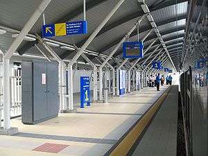
- Railway - Tanjung Malim railway station, Behrang railway station and Slim River railway station
- Bus- Bus Station Tanjong Malim (Cap:400ppl)
- Air- There is no airway in Tanjong Malim, only airfields for helicopters.
Arts, entertainment, and culture
Movies filmed in Tanjong Malim include:
- A Tree in Tanjung Malim By Tan Chui Mui, Best Foreign Short Film, Entre Veus Belford.
Principal Award, 51st Oberhausen International Short Film Festival
- A Thug from Tanjong Malim By Iki Liew, slated for 2009 release.